Yes sorry Steve should have made that clear. I'm just pointing members in the direction of specific threads if people want to find out more. Thanks for all your time and effort on these photos. Viv
-
Welcome to this forum . We are a worldwide group with a common interest in Birmingham and its history. While here, please follow a few simple rules. We ask that you respect other members, thank those who have helped you and please keep your contributions on-topic with the thread.
We do hope you enjoy your visit. BHF Admin Team
You are using an out of date browser. It may not display this or other websites correctly.
You should upgrade or use an alternative browser.
You should upgrade or use an alternative browser.
OLD AND NEW PHOTOGRAPHS
- Thread starter Astoness
- Start date
SteveBhx
master brummie
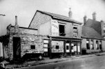
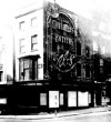
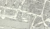
This next picture is title Stevens bar New Street, something for you to work on as the picture has few clues. Corner property with belisha beacon and a street name plaque on the wall , the is also a bit of a slope on the corner, is this Ethel street direction? Love the advert of the side of the building and also the small bay window at first floor - over to you "professionals" !!

RobT
Acemeccanoman
In 1940 Stevens Bar was on the corner of 149 New Street & 89 High Street.This next picture is title Stevens bar New Street, something for you to work on as the picture has few clues. Corner property with belisha beacon and a street name plaque on the wall , the is also a bit of a slope on the corner, is this Ethel street direction? Love the advert of the side of the building and also the small bay window at first floor - over to you "professionals" !!
View attachment 183144
Could the plaque on the wall say Swan Passage?
Last edited:
SteveBhx
master brummie
The next few picture are title the bombing of the Malt Shovel, John Bright Street, EDIT: having a flashback I remember I posted a picture like the first one - but none of the others, but cannot find what was written by members - all I have is a 2008 post which says Area was badly bombed on 19/20 Nov. 1940 a landmine destroyed the pub The Malt Shovel on this island.
My pictures have the following : The bomb damage is the corner of Hill Street & John Bright Street.
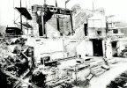
I apologies that these pictures are out of order, its tidy then messy, people are clearing then is full of rubble !!
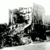
From this view the description I found is accurate what a mess.
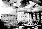
the image above is amazing - we have seen external views but this look inside still has a light and a whole area of glass is complete
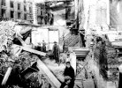
No safety at all here , flat caps and a barrow among all the rubble
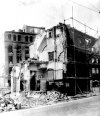
but if you compare this picture to the previous one they did a good job of clearing the mess.
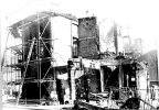
Hope these have not seen previously - amazing how people just got on with their lives -do we know any more about this bombing?
My pictures have the following : The bomb damage is the corner of Hill Street & John Bright Street.

I apologies that these pictures are out of order, its tidy then messy, people are clearing then is full of rubble !!

From this view the description I found is accurate what a mess.

the image above is amazing - we have seen external views but this look inside still has a light and a whole area of glass is complete

No safety at all here , flat caps and a barrow among all the rubble

but if you compare this picture to the previous one they did a good job of clearing the mess.

Hope these have not seen previously - amazing how people just got on with their lives -do we know any more about this bombing?
Last edited:
Radiorails
master brummie
Stevens Bar
Steven's Bar was on the corner of High Street and New Street. Would it have stood where the Rotunda etc now stands? Viv.
 birminghamhistory.co.uk
crikey steve its amazing that the building did not cave in on these men..i can see a framed picture still hanging on the wall in one shotThe next few picture are title the bombing of the Malt Shovel, John Bright Street, EDIT: having a flashback I remember I posted a picture like the first one - but none of the others, but cannot find what was written by members - all I have is a 2008 post which says Area was badly bombed on 19/20 Nov. 1940 a landmine destroyed the pub The Malt Shovel on this island.
My pictures have the following : The bomb damage is the corner of Hill Street & John Bright Street.
View attachment 183149
I apologies that these pictures are out of order, its tidy then messy, people are clearing then is full of rubble !!
View attachment 183150
From this view the description I found is accurate what a mess.
View attachment 183151
the image above is amazing - we have seen external views but this look inside still has a light and a whole area of glass is complete
View attachment 183152
No safety at all here , flat caps and a barrow among all the rubble
View attachment 183153
but if you compare this picture to the previous one they did a good job of clearing the mess.
View attachment 183155
Hope these have not seen previously - amazing how people just got on with their lives -do we know any more about this bombing?
lyn
Covroad
master brummie
I use to go there for a drink, as you say it was frequented by the Irish community (mostly employed on civil and utility construction ) sadly another pub lost.I have drunk in this pub a few times in the 80s, very much an Irish pub back then.
The address then was 28 Havelock Rd, Saltley. I knew it as The Havelock, but it may have officially been The Havelock Tavern.
I have attached a street view from 2009, it was demolished a couple of years later, and also attached is the current street view, you will note the houses have been renumbered
SteveBhx
master brummie
I have moved onto roll A40 now my list is out of order but fortunately I think I have got the identities of the pictures correct.
First up we have the Scala Cinema Smallbrook Street, my information says its under the Queensway now. Love the Cadbury Lorry parked with the rear door open, and the car behind it. The off white tiles of the cinema and the Vogue shop
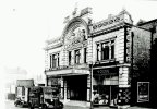
First up we have the Scala Cinema Smallbrook Street, my information says its under the Queensway now. Love the Cadbury Lorry parked with the rear door open, and the car behind it. The off white tiles of the cinema and the Vogue shop

The modern 1960s Odeon on Smallbrook Queensway was also once called the Scala, I assume named after the earlier building. Viv.
SteveBhx
master brummie
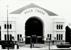
Next we have the Villa Cross Cinema Heathfield Road, taken on a very snowy day. Like the symmetry of the building - windows, columns etc, and the massive entrance arch. Van on the left hasn't been there long as there is no snow on it but the car has - note also the lad in shorts, in this weather!!. Bus stop outside the front - I thought it was more down Heathfield Road just past the shop.

SteveBhx
master brummie
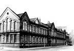
We now move onto the corner of Granville Street and Holloway Head ( although a look at the street nameplate say Bath Row) I need your help though as my information says school - any offers which one? not much to add, two storey with various windows both square and arched and also arched brick frames and the lady with a handbag.

SteveBhx
master brummie
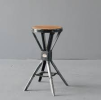
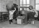
I am sure we have seen lots of similar style pictures of the interior of the workshops in the Jewellery Quarter but another will not harm. So much to see, the stamps and the workbenches, the stove with its chimney at the end, and the old stools . There doesn't seem to be much light as the room looks to be illuminated by the flash off the camera. Gentlemen with overalls and the ladies with aprons - and note the zip up boots on the nearest woman
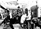

Think the workshop photo must have been taken in winter; dark outside and, as Steve mentioned, the lady's sheepskin-lined booties. Hopefully the stove kept them cozy. Viv
Lady Penelope
master brummie
Steve, we quite often watch Salvage Hunters on TV and the metal stools in the centre of the photo (post 646) are now worth a fortune. I wonder how many of them were just thrown on the skip when the factory closed. Wish I could remember what make they were.
izzy eckerslike
yow've med my day yaw av
splinter555
master brummie
My old school St. Thomas,s and I think Holloway Head ended at Granville St. and Bath Row began at Granville St.We now move onto the corner of Granville Street and Holloway Head ( although a look at the street nameplate say Bath Row) I need your help though as my information says school - any offers which one? not much to add, two storey with various windows both square and arched and also arched brick frames and the lady with a handbag.
View attachment 183388
Chunky AC
master brummie
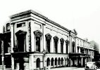
I seem to think this is part of the Old Musem of science and industry in Newhall street. AC.An old museum Newhall Street my list says, clearly Elkington hard to guess at the year - the car looks like its fro the 50's . From the photo we can also see the frontage of the building and the brickwalls to the rear, showing the facade. see also the gas lamp.
View attachment 183389
Yes, thats what I recall tooI seem to think this is part of the Old Musem of science and industry in Newhall street. AC.
Anymore more photos of Alum Rock and/or Washwood heath ? ThanksThis picture is titled looking down Havelock Road with the Havelock on the right hand side, no year I am afraid and not much I can add to the details.
View attachment 183082
if you put alum rock in the search box we should have a thread for itAnymore more photos of Alum Rock and/or Washwood heath ? Thanks
lyn
SteveBhx
master brummie
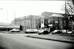
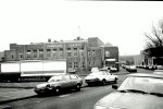
Moving across town we are now in Vauxhall Road and the Co Operative Dairy, an imposing brick built building , the full milk bottling process was was carried out here and I remember seeing the lines of milk bottles marching past when on the train to Duddeston. Not much to add here - nice selection of cars couple of Metros and a Maesto and an old Lada

SteveBhx
master brummie
Another view of the site show the factory and the railway line behind it. I think we are looking down Barrack Street towards the appropriately named Viaduct Street which is on the other side of the previously mentioned railway line. Only other thing to point out is the rather battered Vauxhall Chevette facing us.

SteveBhx
master brummie
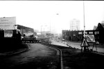
Very much a before shot of a well known view - this is Newtown Row looking towards Newtown, hard to imagine the view these days with only a single lane each way in and out of the city . It seems the whole dualling of the road was carried out between the building lines either side of the road. You do wonder of the logic of making this road into a dual carriageway then have to go back into single lines to cross the canal bridge?!!
