-
Welcome to this forum . We are a worldwide group with a common interest in Birmingham and its history. While here, please follow a few simple rules. We ask that you respect other members, thank those who have helped you and please keep your contributions on-topic with the thread.
We do hope you enjoy your visit. BHF Admin Team
You are using an out of date browser. It may not display this or other websites correctly.
You should upgrade or use an alternative browser.
You should upgrade or use an alternative browser.
Birmingham?
- Thread starter brummie-007
- Start date
Brummie007
proper brummie kid
I’m certain-my Mom & siblings grew up on Grange road before they moved to Burlington road I remember my Mom saying the horse wasn’t far from where they livedIt’s not really a long walk from Grange Rd area and down Jenkins st over the Railway Bridge to the canal wharf area by Bordesley Junction. A possible site for a coal yard.
pjmburns
master brummie
As I posted earlier they were at Grange Road in 1939 but by 1945 they were listed at Hawkes Street and then by 1950 at Burlington Road. There were, of course, no erolls between those 2 dates to check when they moved.I’m certain-my Mom & siblings grew up on Grange road before they moved to Burlington road I remember my Mom saying the horse wasn’t far from where they lived
Brummie007
proper brummie kid
Thank you ive loved reading al these posts really interesting tells me a lot more of where my Mom grew up with her siblings i wished i’d asked more about her growing up
pjmburns
master brummie
I think a lot of us feel like that.Thank you ive loved reading al these posts really interesting tells me a lot more of where my Mom grew up with her siblings i wished i’d asked more about her growing up
Brummie007
proper brummie kid
Your right i have a 101 questions i’d ask now if i had the chance
pjmburns
master brummie
Me too.Your right i have a 101 questions i’d ask now if i had the chance
Last edited:
Brummie007
proper brummie kid
Thankyou Lyn that would be great
brummy-lad
master brummie
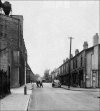
I don’t know if it has already been spotted but photo 1 above has a swan necked lamppost as in the original photo.
I don’t know if it has already been spotted but photo 1 above has a swan necked lamppost as in the original photo.
yes spotted it john but ive got photos of other streets in the area with the same lamp posts so i dont think that helps us much
lyn
brummy-lad
master brummie
Good point Banjo, I thought it looked like a road or dirt track but didn’t twig the lamppost was facing in that direction.Just a final observation (from me). The lampost on the corner is shown "edge on" so, does that suggest it is lighting a road that is running behind the house? That would make it a T junction or a fork.
brummy-lad
master brummie
This is a link to a 1937 aerial view of Grange Road and surrounding streets (Grange Cinema is marked), it is pretty good quality but I can't find the buildings we are looking for, I assume that the industrial building had yet to be built but there is the one in Hawkes Street.
Perhaps someone will have more luck than me.
To be able to zoom in you have to register but it is free.
EDIT: I think that the pins showing various locations only appear if you register.
Perhaps someone will have more luck than me.
To be able to zoom in you have to register but it is free.
EDIT: I think that the pins showing various locations only appear if you register.
Last edited:
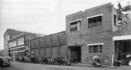
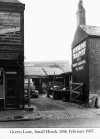
There was a sack/bag factory (Midland Jute Bag co/ Levy Bros Ltd and Knowles Ltd) in Grange road in 1966. It was at no 47, between Eversley road and Bertram road. There was also a coal yard behind the sack factory in Green Lane. (Tranter's Yard -see attached photo- Butler's lamp factory in Grange road can be seen behind the yard)This is a link to a 1937 aerial view of Grange Road and surrounding streets (Grange Cinema is marked), it is pretty good quality but I can't find the buildings we are looking for, I assume that the industrial building had yet to be built but there is the one in Hawkes Street.
Perhaps someone will have more luck than me.
To be able to zoom in you have to register but it is free.
Attachments
Brummie007
proper brummie kid
oh wow that could be it thank you, my Uncle my grandads brother also kept his removal van in the yard
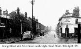
Here's a photo of The Nelson pub in Grange road/Baker street in 1951. On the far Left hand side of the photo, you can just make out the entrance to the bag factory. Bertram road is about 50 yards further on. I lived opposite Bertram road in the 1950's. The old gas lamps were still evident in 1951.oh wow that could be it thank you, my Uncle my grandads brother also kept his removal van in the yard
Attachments
i think that unless we can get a definate same match as this photo we can never been certain of its location..great thread with plenty of ideas and suggestions but nothing definate..
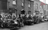
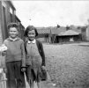
i have have studied the photo again and again and the children look very happy..they seem to be standing on a proper slabbed pavement..there is a cobbled road or path..is it a trick of the camera or does the little girls dress and left hand look grubby (as our mom would say) so has she as suggested been feeding the horse or maybe even helping shovel coal in a coal yard..(its the sort of things we children would have done)
the out building on the left looks to me like its a stable for a horse/horses...the building in the fore front looks like it could be lived in and seems to have a chimney (or is that another trick of the camera as it seems rather large for a property that small)..the buildings on the left of the children do not look like houses so could this be the entrance to a coal yard but we cant see where the coal is stored as its round the corner out of shot and i have never been convinced that the design on the roof of the out building is true..brookfields lad posted this about it
white shapes on the roof are an optical illusion known as the 'Moiré affect'. These patterns occur when a regular shaped pattern is being photographed using equipment set-up incorrectly.
so many questions but nothing definate at the moment
lyn

Last edited:
It's true that the lamposts on the Nelson photo do not match those on the submitted photo. However, the Nelson photo was an earlier photo (1951). If you consider the photo (number 1) that Lyn submitted on #131, this was taken from exactly the same position as the Nelson photo but looking in the opposite direction (i.e. towards Coventry road) and taken at a slightly later time (early 60's?). On her photo, there is a swan neck lampost and If you blow up/magnify her photo you can see older style lamps further down the road past the factory (Butlers). In Lyn's photo number 3 which looks back to the Nelson, you can just make out the older gas lamp outside Butlers., so the newer one must have been fitted around the end of the 1950's early 1960's. judging by the style of the cars. Dunno if this helps to narrow down the date of the original photo.i think that unless we can get a definate same match as this photo we can never been certain of its location..great thread with plenty of ideas and suggestions but nothing definate..
i have have studied the photo again and again and the children look very happy..they seem to be standing on a proper slabbed pavement..there is a cobbled road or path..is it a trick of the camera or does the little girls dress and left hand look grubby (as our mom would say) so has she as suggested been feeding the horse or maybe even helping shovel coal in a coal yard..(its the sort of things we children would have done)
the out building on the left looks to me like its a stable for a horse/horses...the building in the fore front looks like it could be lived in and seems to have a chimney (or is that another trick of the camera as it seems rather large for a property that small)..the buildings on the left of the children do not look like houses so could this be the entrance to a coal yard but we cant see where the coal is stored as its round the corner out of shot and i am not entirely convinced that the design on the roof of the out building is true
so many questions but nothing definate at the moment
lyn
View attachment 194669
Last edited:
brummy-lad
master brummie
This has become a thread like ‘location wanted for this bus if possible’ a very long thread from 2019. Just as interesting as that thread too.
Richard Dye
master brummie
Excellent commentary, can’t disagree with very much.i think that unless we can get a definate same match as this photo we can never been certain of its location..great thread with plenty of ideas and suggestions but nothing definate..
i have have studied the photo again and again and the children look very happy..they seem to be standing on a proper slabbed pavement..there is a cobbled road or path..is it a trick of the camera or does the little girls dress and left hand look grubby (as our mom would say) so has she as suggested been feeding the horse or maybe even helping shovel coal in a coal yard..(its the sort of things we children would have done)
the out building on the left looks to me like its a stable for a horse/horses...the building in the fore front looks like it could be lived in and seems to have a chimney (or is that another trick of the camera as it seems rather large for a property that small)..the buildings on the left of the children do not look like houses so could this be the entrance to a coal yard but we cant see where the coal is stored as its round the corner out of shot and i am not entirely convinced that the design on the roof of the out building is true
so many questions but nothing definate at the moment
lyn
View attachment 194669
pjmburns
master brummie
Based on the look of the girl (born 1939) the photo has to be in the late 40s to very early 50s.It's true that the lamposts on the Nelson photo do not match those on the submitted photo. However, the Nelson photo was an earlier photo (1951). If you consider the photo (number 1) that Lyn submitted on #131, this was taken from exactly the same position as the Nelson photo but looking in the opposite direction (i.e. towards Coventry road) and taken at a slightly later time (early 60's?). On her photo, there is a swan neck lampost and If you blow up/magnify her photo you can see older style lamps further down the road past the factory (Butlers). In Lyn's photo number 3 which looks back to the Nelson, you can just make out the older gas lamp outside Butlers., so the newer one must have been fitted around the end of the 1950's early 1960's. judging by the style of the cars. Dunno if this helps to narrow down the date of the original photo.
Richard Dye
master brummie
Good assumption Janice.Based on the look of the girl (born 1939) the photo has to be in the late 40s to very early 50s.
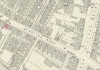
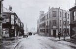
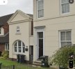
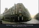
Pedro, you posted this on the Hawkes Street thread. It's not a great archive photo, but it gives a sense of the street. Number 7 Hawkes Street would have been on the right-hand edge of the photo (as per Janice's map in post #60) and directly opposite Butlers (a subsidiary of Joseph Lucas Headlamps). No discernable lamposts, but it might be of general interest to brummie007.

Last edited:
Last edited:

