• Welcome to this forum . We are a worldwide group with a common interest in Birmingham and its history. While here, please follow a few simple rules. We ask that you respect other members, thank those who have helped you and please keep your contributions on-topic with the thread.

    We do hope you enjoy your visit. BHF Admin Team

Birmingham?

Both are referred to as Tranters Yard so presumably the same Viv.
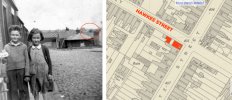
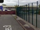
There was a sack/bag factory (Midland Jute Bag co/ Levy Bros Ltd and Knowles Ltd) in Grange road in 1966. It was at no 47, between Eversley road and Bertram road. There was also a coal yard behind the sack factory in Green Lane. (Tranter's Yard -see attached photo- Butler's lamp factory in Grange road can be seen behind the yard)
 
More fuel to the fire! Just came across this photo said to be Green Lane 1954 queue for coal The red arrow is pointing to a property now numbered 151 Green Lane.
Like in Tinpots photo in post #145, were brummie007s ancestors pushing coal in that pram ?
 
For info.

Member Sheldon asked if anyone knows of an Edgar Jones, coalman, in Burlington Street c1965.(from the "Coalman" thread). Sheldon hasn't visited BHF since Sept 2020.
Screenshot_20240904_155930_Samsung Internet.jpg

Member Sheldon was looking to find out more about Edgar Jones - see these two links here


Last edited:
Just ‘strolled down’ Hawkes St 2008 wher if you look at the fencing on the right and the brick courses on the left the road is clearly dropping away. Whilst the building across the bottom of the road is not the one in the original photo it does have a similar footprint. There was even a lamppost still there in 2008. Possibly where original photo was taken.
 

Attachments

  • IMG_0763.jpeg
    IMG_0763.jpeg
    446.5 KB · Views: 22
  • IMG_0764.jpeg
    IMG_0764.jpeg
    513.4 KB · Views: 22
The buildings in the modern view cut off Hawkes Street, it used to reach as far as Muntz Street. Effectively covering half of the road with buildings.
 
Hi
I almost certain they are my Mom & Twin brother i know my grandad was a coalman my Mom told me she used to enjoy feeding the horse would that be where the horse was kept ? if so it was behind the football grounds Blues there are so many similarities with the 2 children
Developing Tinpot's idea of Hawkes Street a little further. Was it this football ground (blue dot) close to where the horse was kept ? (And not the St Andrews ground/Knighthead Park of today.). I think they played their early games on the site shown below and, although its not named, I think the Ground was probably called Muntz Street. This is close to all the locations the family is so far connected with (ie, Burlington Road, Hawkes Street, Green Lane and Grange Road). And possibly in keeping with the family appearing to stick to quite a relatively small, geogrphical area of Small Heath.

I can't seem to fit the buildings or road features in the original photo to Hawkes Street, so wondered if any of the buildings around/nearer the old football ground fit the pattern of buildings in the photo ? Just a thought if time was spent feeding the horse somewhere around here.

Screenshot_20240904_215724_Samsung Internet.jpg
 
Last edited:
just to quote and post an earlier map from jan....so this means they were living at hawkes st between 1939 and 1950...little girl born 1939 so looking at her in the photo looks to me as though the age of her would fit between those dates...

If the yard was near their house in Hawkes Street (1945 address red) then it was also quite near their Grange road address (1939 blue) Also not too far from Burlington Road (1950 green)

image (64).jpg
 
I spotted this house on the original photo which shows there was a street running off to the right (as already suggested) could these be the buildings on the photo? could what we think is a factory roof be the original Birmingham City Football stadium?

I have little knowledge of this area so may just be shooting in the dark.
 

Attachments

  • muntz-street-question.jpg
    muntz-street-question.jpg
    1,023.7 KB · Views: 19
same here john not much knowledge of this area...but anything is possible we could be closing in..this is the problem when folk dont write on the back of old photos....i am very lucky with mine as our dad wrote on the back of most of our old family black and whites..

lyn
 
doubt this will help photos of hawkes st are thin on the ground but i do have this one of the freeholders arms pub no idea where abouts in hawkes st it was

lyn

index.php - 2024-09-05T051601.332.jpg
 
Last edited:
Developing Tinpot's idea of Hawkes Street a little further. Was it this football ground (blue dot) close to where the horse was kept ? (And not the St Andrews ground/Knighthead Park of today.). I think they played their early games on the site shown below and, although its not named, I think the Ground was probably called Muntz Street. This is close to all the locations the family is so far connected with (ie, Burlington Road, Hawkes Street, Green Lane and Grange Road). And possibly in keeping with the family appearing to stick to quite a relatively small, geogrphical area of Small Heath.

I can't seem to fit the buildings or road features in the original photo to Hawkes Street, so wondered if any of the buildings around/nearer the old football ground fit the pattern of buildings in the photo ? Just a thought if time was spent feeding the horse somewhere around here.

View attachment 194689
My Mom said the field where the horse was was not far from where they grew up Grange Road
 
You mentioned "had a yard at the back of the blues ground with a horse my Mom would tell me she would go help feed the horse"

It hadn't occurred to me there might be a field, but of course, that all makes sense. The penny has dropped ! Thanks.

I'm now looking for a space near to Grange Road/Muntz Street/Coventry Road. It was quite built up in the 1940s, but something that strikes me is the area around Grange Road, Dawson Street, Baker Street (another option to add to our list!).

There's now a sports facility there, but it did once have housing. When were the houses cleared (or perhaps bombed during WW2 ?) around here ?

Approximate position of where #128 Grange Road was once located. See Janice's post #149.
Screenshot_20240905_093113_Maps.jpg
Approximate position of #128 Grange Road - overlayed on old map
Screenshot_20240905_090419_Samsung Internet.jpg
Screenshot_20240905_092220_Maps.jpg
 
Last edited:
Date would be pre-1907 and the path/track leading down to that piece of ground became Swanage Road. The houses in that road must be post-1907.
 
Another scenario. What if the children had just left Tranters coalyard (purple dots) (maybe using the pram to bring home coal or visiting), had taken the back exit from the coalyard (red dots) onto Berners Road, then walked on home to their house further along Grange Road. Could the road/path off to the right in the photo be an exit from Tranters yard ? (Today there is a set of gates there giving access into a residential development)

Could the buildings to the bottom of the road (to the right in the photo) be the blue dots on the map? That might mean the building/structure's position with the 'pattern (or trick of the camera) would probably be either on Grange Road or one of the buildings on the unnamed track off Grange Road (as on the map. The track has now gone and that whole piece of land is a sports venue - see post #169) .

Like I say, just another scenario.

Screenshot_20240905_142753_Samsung Internet.jpg
Screenshot_20240905_143537_Samsung Internet.jpg
Screenshot_20240905_145818_Maps.jpg
 
Last edited:
Viv, this aerial view from 1937 shows the area you have marked with purple dots, I don't know if it helps.
Some further back-ground information about Tranter's yard etc -
I lived at 148 Grange Road (bottom of Bertram road on the map) in the late 1950's and early 1960's and I used to fetch coal in my brother's dilapidated pram every Saturday (except in high summer) from Tranter's yard. The yard was totally surrounded by walls, so there was no way through to any roads through there. The space that you can see on the side of Tranter's yard adjacent to Bertram road was used to park cars. My Dad parked our A35 van there at night-times and weekends. After collecting coal, you had to go back out the same way that you came in. I would then trudge down Bertram road and upend the pram to deposit the coal via a hinged grating into the cellar.
The space where the blue dots are were gardens leading down to two houses. The house on the LHS was owned by a keen gardener who fenced his front garden off to preserve his plants etc. Next door to him lived Gerry, who is the owner of Small Heath Circle website.
Incidentally, on the corner of Bertram Road opposite our house was a grocery shop called Brown's. One of Mr Brown's daughters was Polly Brown of the 70's group Pickettywitch. Her sister used to perm my Mom's hair!
 
Last edited:
That's really helpful Pedro. So it sounds like the children in brummie007s photo would have to go back onto Green Lane to turn into Bertram Road.

Also sounds like the buildings in brummie007s photo weren't the ones at the bottom of Bertram Road. Another site eliminated from our research, but we're certainly getting to know the area !
 
My Grandad Wood lived at 87 Bordesley Park Rd in 1918, he had just got married to Violet Baynes. In other tracings, I came across a mention of Samson Rd or the back of Samson Rd, I think it was the last address of his wife Violet Baynes..
 
My Grandad Wood lived at 87 Bordesley Park Rd in 1918, he had just got married to Violet Baynes. In other tracings, I came across a mention of Samson Rd or the back of Samson Rd, I think it was the last address of his wife Violet Baynes..
Welcome to the Forum mack UK, enjoy!
 
Back
Top