-
Welcome to this forum . We are a worldwide group with a common interest in Birmingham and its history. While here, please follow a few simple rules. We ask that you respect other members, thank those who have helped you and please keep your contributions on-topic with the thread.
We do hope you enjoy your visit. BHF Admin Team
You are using an out of date browser. It may not display this or other websites correctly.
You should upgrade or use an alternative browser.
You should upgrade or use an alternative browser.
Birmingham?
- Thread starter brummie-007
- Start date
Not a pretty sight Lyn, although the girl was enjoying her moment of fame dangling those rats !
I think the film focuses on the lower, flatter end of Bolton Road, nearer Golden Hiilock Road, quite a way from the Arthur Street and Herbert Road end. The top end near Arthur Street is closer to the embankment. It's a long road too.
I think the film focuses on the lower, flatter end of Bolton Road, nearer Golden Hiilock Road, quite a way from the Arthur Street and Herbert Road end. The top end near Arthur Street is closer to the embankment. It's a long road too.
Last edited:
Richard Dye
master brummie
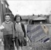
Born in ‘43 I can relate to the boys clothes, the style which was carried well into the 50’s.If so, it would date the photo as the latter part of the 1940s. Clothes for children at that time are difficult to date, especially because of war/post-war rationing and handed down clothes etc. The girl's dress looks to me as though it's been hand-sewn, probably made from another dress judging by the bodice. (Looks like a tartan/check material). The cardigan could well be 1940s (possibly with a thin row of fairisle or other pattern). Likewise the boy's sweater could easily be 1940s, it seems to have had the hem removed. I'd say his trousers are definitely handed down.
The style of the pram would fit with the 1940s/50s, as this was a design that was pretty much unchanged for many years into the 1960s and early 70s. The pram handle and brake handle look newish.
pjmburns
master brummie
If I have the right place it wasn't called Bolton Rod that far round in the 1940s and 50s.Not a pretty sight Lyn, although the girl was enjoying her moment of fame dangling those rats !
I think the film focuses on the lower, flatter end of Bolton Road, quite a way from the Arthur Street and Herbert Road end. The top end near Arthur Street is closer to the embankment. It's a long road too.

In what sense Janice ?
Oh I see. Quite possibly Janice. I'm currently at the stage where I've looked as so much material, that anything seems possible ! It's worth having a look at that, and ultimately it would be great to pin down the use of the buildings. If Bolton Road is our place, very little is left standing from pre-1970, probably only the tram depot in fact. Makes it a difficult search.
brummy-lad
master brummie
Banjo
master brummie
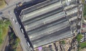
Only saw this thread today. If I may, here is my opinion on it. I can only see a factory building rather than a bridge. You can see faint images of a drainpipe and a window on that building as well as the large opening. I've enhanced what I can see in this attachment. Sorry, just another opinion amongst many as I've no idea of where that is.

pjmburns
master brummie
Just a suggestion. I wasn't sure what the buildings were like in 1945.The satellite view of the tram depot (I think the roof is original) seems to indicate that the formation of the skylights does not match.
This area is very complicated. Looking at maps, the route of Bolton Road Is different now to before the area was redeveloped. At one time part of the road was located further away from the embankment. And it was also extended before reaching Arthur Road and over to Herbert Road (as Janice suggested). I'm finding it difficult to work out precisely the extent that Bordesley Park Road became Bolton Road. Janice has suggested a loop - is this the point where Bordesley Park Road reached 'our' side of the railway tracks ? In any case, today, only a small section remains on the other side of the railway tracks. I think these changes must have happened when the area was redeveloped in the 1970s. So looking at addresses here is going to prove very tricky.
Maybe someone can clarify the changes to the road and dates if possible. The reason I ask is because there are a number of photos for Bordesley Park Road which might be of help if the section they portray became Bolton Road, especially where the road was re-routed closer to the embankment.
Maybe someone can clarify the changes to the road and dates if possible. The reason I ask is because there are a number of photos for Bordesley Park Road which might be of help if the section they portray became Bolton Road, especially where the road was re-routed closer to the embankment.
Last edited:
Brookfields Lad
master brummie
 Might I suggest that the white shapes on the roof are an optical illusion known as the 'Moiré affect'. These patterns occur when a regular shaped pattern is being photographed using equipment set-up incorrectly.
 More info here:
https://photographylife.com/what-is-moire#:~:text=Moiré pattern occurs when a scene or an
I could be wrong and the shapes on the roof did exist. If my theory is correct and it is an optical illusion, that opens another can of worms.
Best of luck.
Good point, thanks for that ! Think it's a strong possibility.
Richard Dye
master brummie
I think from your enhancement it is a building and not a bridge, circa 1943/49 from the clothes.Only saw this thread today. If I may, here is my opinion on it. I can only see a factory building rather than a bridge. You can see faint images of a drainpipe and a window on that building as well as the large opening. I've enhanced what I can see in this attachment. Sorry, just another opinion amongst many as I've no idea of where that is.
View attachment 194614
My memory, and I hope I'm correct, is that Bolton Road ran in a straight line to the railway bridge as seen on #66 where it joined what I think was Bordesley Park Road. I can't help with the dates of re-routing though.This area is very complicated. Looking at maps, the route of Bolton Road Is different now to before the area was redeveloped. At one time part of the road was located further away from the embankment. And it was also extended before reaching Arthur Road and over to Herbert Road (as Janice suggested). I'm finding it difficult to work out precisely the extent that Bordesley Park Road became Bolton Road. Janice has suggested a loop - is this the point where Bordesley Park Road reached 'our' side of the railway tracks ? In any case, today, only a small section remains on the other side of the railway tracks. I think these changes must have happened when the area was redeveloped in the 1970s. So looking at addresses here is going to prove very tricky.
Maybe someone can clarify the changes to the road and dates if possible. The reason I ask is because there are a number of photos for Bordesley Park Road which might be of help if the section they portray became Bolton Road, especially where the road was re-routed closer to the embankment.
Last edited by a moderator:
Thanks Clive, very helpful. I think that's the section that was moved.
Viv. There would have been a lot of changes in that area to accommodate the big island called Bordesley Circus and the bypass, Small Heath Highway which was created to relieve the traffic on Coventry Road. It completely changed the landscape in that area.Thanks Clive, very helpful. I think that's the section that was moved.
pjmburns
master brummie
This may help - won't save a right map. Enter "Bolton road birmingham" in search on left hand map.
Will copy when I put laptop on.
Will copy when I put laptop on.

Last edited:
brummy-lad
master brummie
This may help - won't save a right map. Enter "Bolton road birmingham" in search on left hand map.
Will copy when I put laptop on.
foot print may have changed a little at the other end of the road but does not look too much...for those who do not know just move the blue dot to see what is there now
Yes, I used the maps but with the overlay function. What I'm getting at is this shown below in red. The road changed significantlly. Before the changes this was Bordesley Park Road sometime later Bolton Road was built alongside the railway embankment (to replace BPR but when ?).
I ask because some photos labelled as Bordesley Park Road might show the old road (BPRd) before this section of Bolton Road was extended and replaced this section of BPRd. Was this road change all part of the 1970s redevelopment - ie so after brummie007's original photo ? Or did the name of the old section of BPRd change to Bolton Road before it moved/was built alongside the ebankment ?
So in a nutshell, did this section of Bordesley Park Road become Bolton Road before the road changes ? If not, the photo may have actually been taken on Bordesley Park Road.
The last red dot (bottom) where the road ends on the embankment is interesting. Wondered what the buildings (blue dots) were just above it ? Housing or commercial/railway buildings ?
(And just for interest that section of housing that disappeared - where the red arrows are - contained roads named the Grove and the Retreat)
Last edited:
viv in answer to your question
So in a nutshell, did this section of Bordesley Park Road become Bolton Road before the road changes ? If not, the photo may have actually been taken on Bordesley Park Road.
looking at the old photos i have of bordesley park road no
lyn
So in a nutshell, did this section of Bordesley Park Road become Bolton Road before the road changes ? If not, the photo may have actually been taken on Bordesley Park Road.
looking at the old photos i have of bordesley park road no
lyn


pjmburns
master brummie
This post on the Bordesley Park Road thread suggests the road change occurred i the early 70s (or possibly late 60s).
Wow these pictures that Lynn posted are fantastic and very nostalgic, on the one photo (with the 28 Bus going under the Bridge towards Town) this was taken from where my parents lived..or near enough. We moved into the area in 1973 when the new estate was built on Bordesley Park Road which became an extention of Bolton Road all the way to Arthur Street and Herbert Road, not much of Bordesley Park Road exists now only a little bit that goes into Macdonalds. I remember them building the A45 bypass which kind of split Bolton Road into two sections as kids we played on the huge concrete pipes...