• Welcome to this forum . We are a worldwide group with a common interest in Birmingham and its history. While here, please follow a few simple rules. We ask that you respect other members, thank those who have helped you and please keep your contributions on-topic with the thread.

    We do hope you enjoy your visit. BHF Admin Team
  • HI folks the server that hosts the site completely died including the Hdd's and backups.
    Luckily i create an offsite backup once a week! this has now been restored so we have lost a few days posts.
    im still fixing things at the moment so bear with me and im still working on all images 90% are fine the others im working on now
    we are now using a backup solution

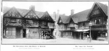
High Street Deritend

Well here is a recent photo showing the two tall buildings in the background, nos 62-64

This is where threads go adrift, or get confusing ... Lyn posted her Old Guy pic question on this thread but the pub was in Digbeth. I replied saying that the closest pic I have is No.62 because I was trying to answer her question/query. However, I was referring to No.62 Digbeth which was a very short distance from the Old Guy. Still, thanks for the photograph of High Street Deritend. I am nearly at the point of covering these - I have now completed my tour of the southern side of the street :

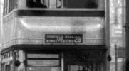
 
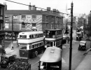
Well it a route 29 bus on its way from Highfield Road, Hall Green to Kingstanding. The more famous 29A did not commence until January 1936.
The bus seems to be from the series 409 - 443 OG 309 - OG 443 and were put into service in mid to late 1930. Some were re bodied with wartime bodies 1943/4.
They had AEC petrol engines. This my first choice.

There was also another 20 buses, of very similar style 484 - 503 OV 4484 - OV 4503 which were put into service 1931/2.
They also had AEC petrol engines. Bus 486 OV 4486 is at Wythall Transport Museum in resplendent condition having been preserved.
Ta very much - I knew you would come up trumps with the bus info. Gold star in the post.
 
Ta very much - I knew you would come up trumps with the bus info. Gold star in the post.

I cannot enlarge it any more as it would pixelate and make it even harder to read. You can see why I thought it was a 25 or 26 but I can now see your 29 and the bottom line of Kingstanding. Quite a long route and a surprise to a non-bus person like myself as I imagined most routes to start and finish in town rather than pass through it.
 

Attachments

  • Bus.jpg
    Bus.jpg
    92.6 KB · Views: 13
I am interested to see opposite the Crown in Digbeth (or Deritend), Just about where the Green Man Inn was at about 40 or 41 Hight Street and entrance to 9 & 10 Courts. Please, has someone got any photos? Never seen one yet x
 
1908 Kelly's directory - entry for shop in right hand photo

1650902889781.png

The shop next door appears to be a confectioner Geo Hy Rodway.
 
Last edited:
The debate about boundaries of Digbeth, Deritend and Bordesley but of more interest to me is the fact that in 1849 there is another business carrying on at the same premises as my ancestors, Rhodes, Fire Iron Mfrs. I wonder who was there first?
 
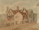
This is Samuel Lines' Snr 1800 painting of Deritend Bridge High Street. Be interesting to know the location in relation to today's map if anyone can tell us. Viv.

Screenshot_20230824_181232_Chrome.jpg
 
Last edited:
crikey thats an old one viv...hoping someone can figure out todays location..as it say deritend bridge maybe its near the river rea...just a thought

lyn
 
Last edited:
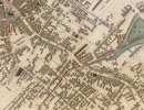
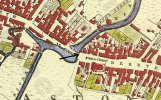
On the map posted by MWS there's 'TB' marked next to the building. Would this (the building in Lines's painting) have later been a tollbooth/tollgate - ie possibly after the date of the painting? Not even sure there was a toll gate at Deritend/Digbeth. Don't think I've ever read about one. Viv
 
On the map posted by MWS there's 'TB' marked next to the building. Would this (the building in Lines's painting) have later been a tollbooth/tollgate - ie possibly after the date of the painting? Not even sure there was a toll gate at Deritend/Digbeth. Don't think I've ever read about one. Viv
dont think so viv as i can see another 2 TBs on the line of the rea both to the left of the TB at deritend bridge

lyn
 
Lyn
They happen to be where the Rea crosses the road, but that seems to be where the tollhouses were placed. There was one in Bradford st, and another on thr moseley road
ahh i see thanks mike so viv was right about them being toll booths...we never stop learning

lyn
 
Edit. This is the detail Mikejee mentioned in post #54. Apolgies Mike hadn't realised there was a link in your post,

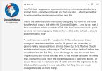
Our member Dennis Williams gave us some information on the Toll booths of Birmingham thread extracted from his grandma's written recollections of Birmingham. The Old Crown isn't too far from the TB marked on the map.So maybe the Crown (or nearby) took over the job. We know the bridge was altered and the road changed over time so this could be poss8ble. Viv
Screenshot_20230827_070821_Chrome.jpg
 
Last edited:
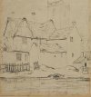
This is a Lines' drawing of the same location as in post #46 but drawn from alongside the river. It shows how low down the buildings were in relation to the road above. You can see St John's Church looming behind the buildings. Viv.

Screenshot_20230827_081937_Chrome.jpg
 
Back
Top