• Welcome to this forum . We are a worldwide group with a common interest in Birmingham and its history. While here, please follow a few simple rules. We ask that you respect other members, thank those who have helped you and please keep your contributions on-topic with the thread.

    We do hope you enjoy your visit. BHF Admin Team
  • HI folks the server that hosts the site completely died including the Hdd's and backups.
    Luckily i create an offsite backup once a week! this has now been restored so we have lost a few days posts.
    im still fixing things at the moment so bear with me and im still working on all images 90% are fine the others im working on now
    we are now using a backup solution

Camp Hill

This view of Holy Trinity shows the edge of Bradford Street (?)Camp Hill to the right, which today must be somewhere near the roundabout at (Old) Camp Hill. No date for the eBay postcard. Viv.
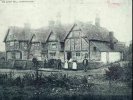
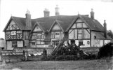
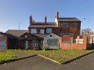
4CE3CC83-CC18-462A-A4EA-7F20383793B3.jpegD468DE6F-FC0B-4975-BC9B-07CFE04FD462.jpeg
 
Now found a 1954 Phyllis Nicklin photo posted by the late Phil on the Holy Trinity thread. It shows more of the buildings to the right. Was this the top of Bradford Street ? Viv.

B5E7FF53-EF2D-49E6-B419-8AE743FF73FC.jpeg
 
My Nan and grandad were married at that church. I know it was being used as a Night Shelter in more recent years - not sure what's happening there now but apparently it was up for sale in 2014 for £3million!
 
Where would number 82 Camp Hill be located ?, the address was mentioned in my grandads divorce papers in 1920, along with Shut Lane off Park Street, Never heard of Shut Lane before ..
 
Here's a map of Camp Hill from 1951 with the numbers on. It is not very clear but I think 82 (marked by 2 pink dots) was next to the church...

Camp Hill.jpg

Shut Lane ran between Moor St and Park St alongside the railway line. This from 1951 and there are not many properties remaining...

Shut Lane.jpg
 
I think the Fulford Hall reference in the other thread is erroneous. The locations for Grove Farm and 58 Camp Hill are quite close to each other in Birmingham whereas Fulford Hall is in Solihull I believe.
 
I dont know the year but it looks pre 1900s

I think the building shown in #39 is Grove Farm .... located in Sparkhill, where Grove Road is now.
Here's another photo, tagged with a date of 1895.
 

Attachments

  • Sparkhill Grove Farm (demolished 1897) 1895.jpg
    Sparkhill Grove Farm (demolished 1897) 1895.jpg
    168.4 KB · Views: 21
I’ve seen this c1900s image many times but not been entirely sure where it is in terms of today’s road layout. Looking at Google I see there’s was a derelict pub there on Camp Hill Circus (well 12 years ago, it was The Brewer and Baker). Is this where the Ship Inn was previously sited ? The place bears no resemblance to the old image, only Holy Trinity in the distance provides some clues. Viv.

74670A3C-E973-4203-936A-432A01D1FCF0.jpeg
 

Attachments

  • 0139B5EC-BE41-4F7D-9E86-745A7887766E.jpeg
    0139B5EC-BE41-4F7D-9E86-745A7887766E.jpeg
    387 KB · Views: 22
  • EC20FAC2-F62E-44C1-B579-92F7209DFDDF.jpeg
    EC20FAC2-F62E-44C1-B579-92F7209DFDDF.jpeg
    290 KB · Views: 22
Last edited:
I’ve seen this c1900s image many times but not been entirely sure where it is in terms of today’s road layout. Looking at Google I see there’s was a derelict pub there on Camp Hill Circus (well 12 years ago, it was The Brewer and Baker). Is this where the Ship Inn was previously sited ? The place bears no resemblance to the old image, only Holy Trinity in the distance provides some clues. Viv.

View attachment 174249
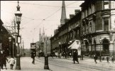
is that the stratford rd junction of camp hill
 
It certainly takes some working out as the roads have altered with the development of the roundabout (Camp Hill Circus), but I think Sandy Lane was the road to the right side of the Ship (later becoming part of Bordesley Middleway?), then Camp HIll to the left side of the Ship. So further to the left would it have been Ravenhurst Street ? Then would it make the road coming towards the photographer - away from the Ship - Stratford Road ?

Viv.

17871B72-6CD3-4488-A3F0-378CE8CED2C9.jpeg
 
Last edited:
I’ve seen this c1900s image many times but not been entirely sure where it is in terms of today’s road layout. Looking at Google I see there’s was a derelict pub there on Camp Hill Circus (well 12 years ago, it was The Brewer and Baker). Is this where the Ship Inn was previously sited ? The place bears no resemblance to the old image, only Holy Trinity in the distance provides some clues. Viv.

View attachment 174249
#45 pic.stratford rd junction sandy lane ....... i remember the shops on the right just past the ship. thats were i took my saturday night suit to have it cleaned
 
Picture in post #45, I would say the is from Stratford Place (the posts are marked on the map). Just beyond is Ravenshurst Street, then Camp Hill and Sandy Lane as mentioned. Stratford Street would been off to the right and Stratford Road behind and to the right.

0 - Ship Hotel 1.jpg
 
It certainly takes some working out as the roads have altered with the development of the roundabout (Camp Hill Circus), but I think Sandy Lane was the road to the right side of the Ship (later becoming part of Bordesley Middleway?), then Camp HIll to the left side of the Ship. So further to the left would it have been Ravenhurst Street ? Then would it make the road coming towards the photographer - away from the Ship - Stratford Road ?

Viv.

View attachment 174281
I feel secure with this view, the pavement on the right is where I poured out of school at 4.10pm in the 1950's.The tram lines were still there. My mind has not been confused with the "recent" developments. I expect buses to be yellow and blue, the occasional one to be red.
 
Hi Jim,

Memories of the 13A, 24, 36,37,44,44a, the Midland Red 150, and not to forget the occasional
150 Stratford Blue.

And there was a shop near the bus stops which used to sell Wagon Wheels when they were a proper
size and taste. I used to have one after school whilst waiting for the 36, and I still miss them now
(the Wagon Wheels, not the bus stops!).

And do you remember how the prefects used to patrol the gate in the mornings to catch anyone not
wearing a School cap. If you hadn't got yours, the trick was to waylay a friend, and get them to go round
to the Stratford Street North wall once they were in school, and throw their's over the wall to you.

Happy days

Kind regards
Dave
Dave, I used to get a 1d, yes 1d, bun from the shop just beyond the "Ship". I see the 37 now goes to Acock's Green, how confusing. I had to walk down Camp Hill to catch a Coventry Rd bus under the rail bridge, or by the boiled sweet shop, troach?
All a long time ago!
 
I had a wide choice of buses to get me from Camp Hill back to Hall Green. Apart from the 37 there was also the 32 to Sarehole Road or Hall Green Parade. The 29A could also take me to Sarehole Mill and then a short walk down Sarehole Road. A 31A would also go to the Stratford Road end of Sarehole Road.
 
Not to forget the 29 Highfield Road and in addition to the 150 Stratford upon Avon.there was 154 to Solihull,, 179 to Earlswood, and 153 and 183 to Monkspath and Cranmore Boulevard.
 
Another picture of the Ship Hotel, I'm sure the KEG School wasn't built on this site.

And another picture…SHIP HOTEL, CAMP HiLL.

“ In the year before the CBT steam tram service was extended to College Road, Springfield, in 1899, an almost new Kitson 'Standard Improved' steam tram locomotive, No. 90, trundles towards the junction with Sandy Lane, on its way to the Sparkhill terminus, despite the destination board showing SPARKBROOK. When the area was developed after the opening of Camp Hill Goods Yard by the Birmingham & Gloucester Railway in 1841, the rebuilt Ship Hotel, which dated from around 1868. had a subtitled name which harked back to the English Civil War. This name was 'Prince Rupert's Headquarters - 1643', and they even had a statue of Prince Rupert in a niche below the Ship Hotel name. The pub was demolished in 1972 as part of a new road scheme for the area. (Whybrow Collection).

Birmingham before the electric tram by Harvey, D. R. (David R.), author. Publication date 2013


IMG_0422.jpeg
 
Back
Top