-
Welcome to this forum . We are a worldwide group with a common interest in Birmingham and its history. While here, please follow a few simple rules. We ask that you respect other members, thank those who have helped you and please keep your contributions on-topic with the thread.
We do hope you enjoy your visit. BHF Admin Team
You are using an out of date browser. It may not display this or other websites correctly.
You should upgrade or use an alternative browser.
You should upgrade or use an alternative browser.
Then & Now
- Thread starter Phil
- Start date
Radiorails
master brummie
Pedrocut
Master Barmmie
oM, your post #564 - A really good picture but not sure what to make of the Marsh & Baxter's ad with a pig pulling the cart loaded with sausages!
Reminds me of Butch and Sundance the ones that got away..
Lady Penelope
master brummie
oM, that's like trundling back from the guillotine with your mates on the back. Nice pig though!
oldMohawk
gone but not forgotten
As far as I can tell this is a photo of 148 Cotterills Lane and the damage occured on the same night as the Torrey Grove raid 10 April 1941. Through the gap can be seen houses in Pelham Road. Barra report that four people at this address were injured in the raid. House 229 was on the opposite side towards Eastfield Rd and would have received blast damage from the Torrey Grove bombs. See http://barra.historynut.co.uk/Re #567, my dad, nan and granddad lived at 229 Cotterill's Lane which I think would have been at the bottom of the newer picture. Not sure how much damage there was to their house but they had to move after that raid.

shoothill
The view today.

Aerial View and the house which was bombed marked.

Another aerial view and I have put a yellow circle on house 229 Cotterills Lane which would certainly have received some blast damage from the Torrey Grove bombs.

Last edited:
devonjim
master brummie
In 1960's Stanford & Mann was very much a favourite shop of mine!Finishing off our little tour of Victoria Square, we have Christchurch passage seen from New Street and Waterloo Street.
View attachment 133270View attachment 133271
oldMohawk
gone but not forgotten
Birmingham Council Housing Department owned at one stage around 140,000 houses. They had a similar celebration on completion of their 125,000th (I think) house in Greenwood Place off Finchley Road Kingstading.
One of the tenants told me how the Council celebrated this wonderful achievement. They had a marquee on the island and invited lots of very important people. Armed with drinks and cucumber sandwiches for the dignity’s, and to lots of cheers and hoorays the key was presented to the unsuspecting new tenant on a velvet cushion in the self-adulating way officials do when spending other people money.
The 125,000th house had chrome taps and a posh range in the front room. All the other dwellings in Greenwood Place has brass taps and a Triplex range. After the celebrations were complete and no longer than it took for the ink to dry on the tenancy agreement, the council workmen came around and changed the taps back the brass. They could not change the range fortunately, as this was built in.
What a funny story.
You don’t often see privet hedging in front gardens these days (much of it removed to create parking spaces). Expect these houses have kept their privet because there’s no direct road access at the front of the house. Viv.
guilbert53
master brummie
In the early and mid 1980s (just after I had moved from London to Birmingham) I went round the Broad St area taking photos while they rebuilt the whole area (ICC, NIA, Brindley place etc).
I then went back a few years ago (2010 / 2011) and retook many of the photos from the same place, to get a lot of "before and after" photos.
I have about 30 "views" and this is called "View 1" (I will post other "views" later).
This is Old Turn Junction right in the centre of Birmingham. Photo take early in the early 1980s (not sure of exact date).
In the distance is where Broad St cross over the canal. Right at the back (the tall building) is an old brewery).
I have to say when I walked around the area in that period (mostly on a Sunday) I could walk for hours and not see another person.

Below is roughly the same view taken in 2010.
On the left we have the ICC (International Convention Centre) and behind that the Hyatt Hotel on Broad Street.
On the right we have the Sea Life Centre and behind that Brindley Place.
Behind where I am standing (out of shot of course) we have the NIA (National Indoor Arena) now called Arena Birmingham.
This photo was taken on a cold 27th November 2010 with few people about, normally the area is packed with people

I then went back a few years ago (2010 / 2011) and retook many of the photos from the same place, to get a lot of "before and after" photos.
I have about 30 "views" and this is called "View 1" (I will post other "views" later).
This is Old Turn Junction right in the centre of Birmingham. Photo take early in the early 1980s (not sure of exact date).
In the distance is where Broad St cross over the canal. Right at the back (the tall building) is an old brewery).
I have to say when I walked around the area in that period (mostly on a Sunday) I could walk for hours and not see another person.

Below is roughly the same view taken in 2010.
On the left we have the ICC (International Convention Centre) and behind that the Hyatt Hotel on Broad Street.
On the right we have the Sea Life Centre and behind that Brindley Place.
Behind where I am standing (out of shot of course) we have the NIA (National Indoor Arena) now called Arena Birmingham.
This photo was taken on a cold 27th November 2010 with few people about, normally the area is packed with people

Last edited:
That’s great Gilbert. I think it’s worth you starting a new thread of your own for these. Very interesting. Viv.
Mort,
It must have cost them more to change the taps than the difference in the cost of the taps. Even back then the so-called people's representatives worked for themselves rather than the people!
Maurice
Yes, at the time I thought the same. However knowing the housing department, it was not a supersize, cost would always lose out to principals
guilbert53
master brummie
That’s great Gilbert. I think it’s worth you starting a new thread of your own for these. Very interesting. Viv.
Viv, happy to create a new topic and post all 30 views if you like (I did post them on this web site years ago before the site was hacked and all the photos were deleted).
Can you suggest which part of the site I should create this new topic, it is such a huge site !
Shall I create a new topic in "Made in Brum / Old Photographs ?
Yes Guilbert that’s a good place for your thread. Look forward to seeing your compared photos - in your own time of course. Viv.
Pedrocut
Master Barmmie
In the early and mid 1980s (just after I had moved from London to Birmingham) I went round the Broad St area taking photos while they rebuilt the whole area (ICC, NIA, Brindley place etc).
I then went back a few years ago (2010 / 2011) and retook many of the photos from the same place, to get a lot of "before and after" photos.
I have about 30 "views" and this is called "View 1" (I will post other "views" later).
This is Old Turn Junction right in the centre of Birmingham. Photo take early in the early 1980s (not sure of exact date).
In the distance is where Broad St cross over the canal. Right at the back (the tall building) is an old brewery).
I have to say when I walked around the area in that period (mostly on a Sunday) I could walk for hours and not see another person.
View attachment 133336
Below is roughly the same view taken in 2010.
On the left we have the ICC (International Convention Centre) and behind that the Hyatt Hotel on Broad Street.
On the right we have the Sea Life Centre and behind that Brindley Place.
Behind where I am standing (out of shot of course) we have the NIA (National Indoor Arena) now called Arena Birmingham.
This photo was taken on a cold 27th November 2010 with few people about, normally the area is packed with people
View attachment 133337
One for the Canal enthusiasts. The first picture shows the sign for Farmer's Bridge Junction. On the modern picture it says Old Turn junction.
impis
knowlegable brummie
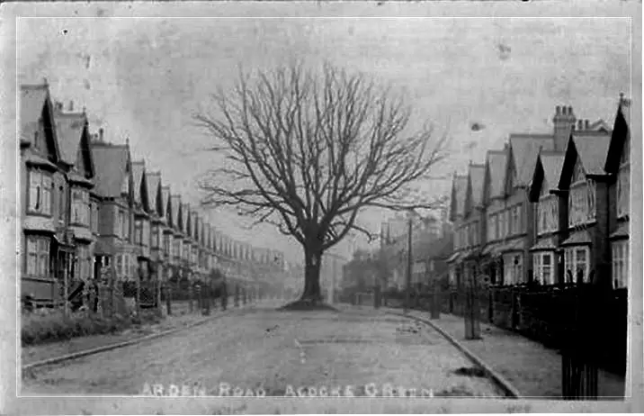
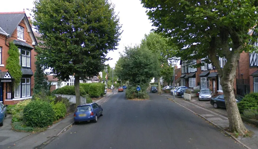
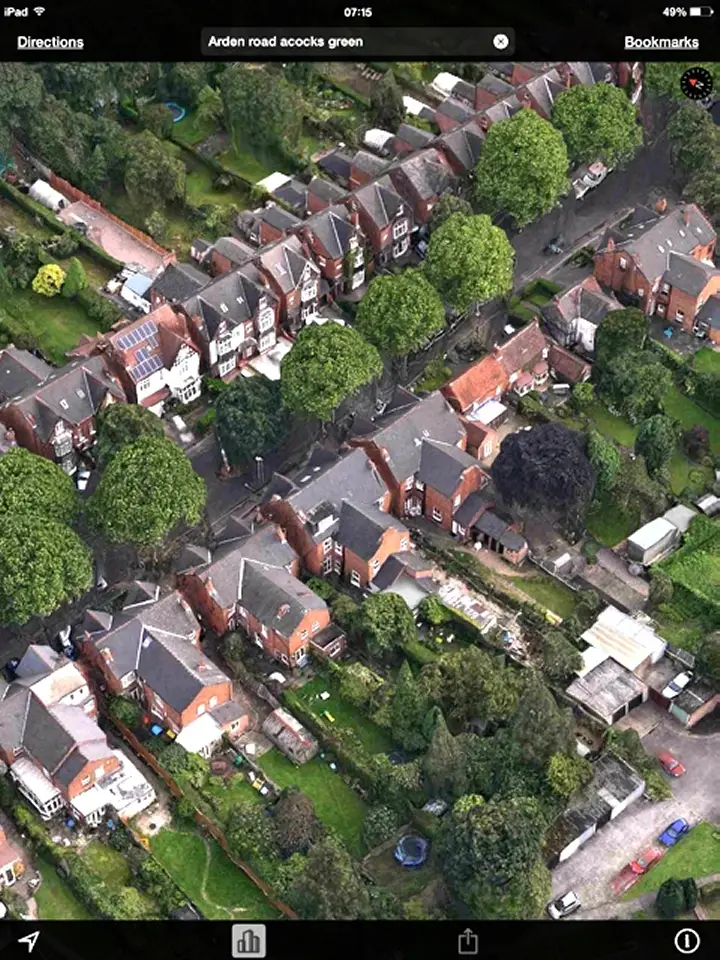
It is the same tree in all photos. It is called The Arden Oak, and is supposed to be the last remaining tree from the forest of Arden that used to cover this area. As such, it is a tree of importance, and therefore, they built the road around it. Other information about it can be found here: https://books.google.co.uk/books?id...e arden oak" Arden road, acocks green&f=falseTaking up your invitation Phil, the old forum photo shown below of Arden Rd Acocks Green c1915 has always intrigued me. Was there something special about that tree for them to leave it in the middle of the road ? The second photo dated 2010 shows the same patch with a new tree, and a flyover photo today shows the patch still there in front of the house with the solar panels on the roof.
In 1915

In 2010

Flyover now

The upper two pics were originally here.
Phil
Gone, but not forgotten.
This is the junction of Coventry Road and Gladys Road Hay Mills approaching the Swan Island coming from town. Does anybody know the reason why such a nice looking house was vandalised in such a way as to demolish half of it and remove the top storey. Was it the result of bombing during the war, a fire or a gas explosion. I just can't think of any structural reason that would justify what was done.


Phil
Gone, but not forgotten.
On bomb plot maps it shows a bomb was dropped on Gladys Road a little further down on the other side of the road. I can't see this being a responsible cause for the works as the corner building on the same side opposite to the building in question appears to have been undamaged.
Pedrocut
Master Barmmie
This is the junction of Coventry Road and Gladys Road Hay Mills approaching the Swan Island coming from town. Does anybody know the reason why such a nice looking house was vandalised in such a way as to demolish half of it and remove the top storey. Was it the result of bombing during the war, a fire or a gas explosion. I just can't think of any structural reason that would justify what was done.
View attachment 133400
The Google 3D from the rear seems to suggest that part of the house had been taken down to allow extensions on the rear and a garden on the side. It looks like the garden will be illuminated!

Radiorails
master brummie
I wonder if there were plans to widen Gladys Road, build an over bridge or subway which might have caused partial demolition of the house? This, if the case, did not happen it would seem. I notice that Gladys Road is now a cul-de-sac with no exit into Coventry Road and a lay-by for turning in probably what was once part of the house garden.


