• Welcome to this forum . We are a worldwide group with a common interest in Birmingham and its history. While here, please follow a few simple rules. We ask that you respect other members, thank those who have helped you and please keep your contributions on-topic with the thread.

    We do hope you enjoy your visit. BHF Admin Team

Then & Now

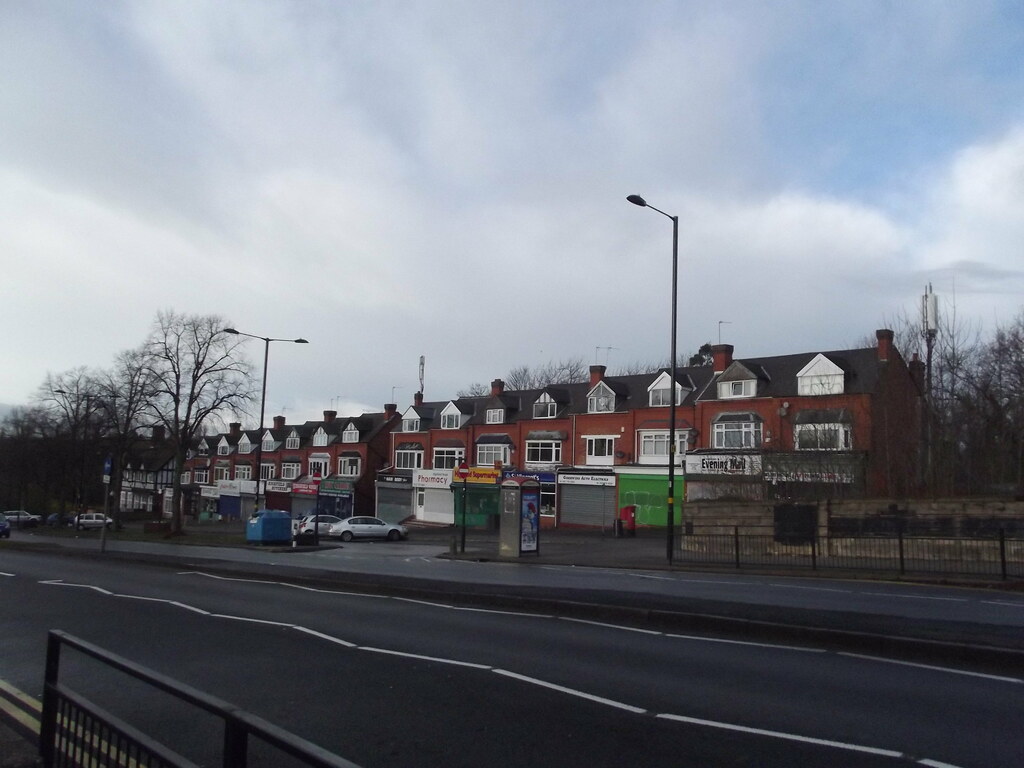
In April 1941 a row of shops in Highfield Rd Yardley Wood near the junction with Cole Valley Rd looked like this after the previous night's air raid. The building on the left with the man sitting on the roof edge above the gable end is now named the 'Ruby Garden'.
Then
HighfieldRdThen.jpg
Now
HighfieldRdNow.jpg
https://goo.gl/maps/wPiqGUMaDbN2

Another view from 1941
ThenHighfieldRd.jpg
Now
NowHighfieldRd.jpg
 
phil they did a nice job of replacing the highfield road shops i think

lyn
Yes Lyn, I’ve looked closely at the brickwork and they have matched it exactly. Pity about the shutters on some shops but I suppose it is normal these days. The bins await the ‘bin-men’ but those communication cabinets look obtrusive.
Phil
 
Cant even see the join, amazing. Why would they go to so much trouble to match the buildings, just after the war.
I live not far away, and didn't know the shops had been bombed.
 
Thanks for that Morturn. Think I ought to do a bit more research closer to home. I know there are some Shoothill photos of Swanshurst Lane.
 
There is a 'then and now' pic of bomb damage at 165 Swanhurst Lane in post#91 in another thread ... :)https://birminghamhistory.co.uk/for...age-in-unidentified-streets.45254/post-550936
bus stop still in same place ....
index.php
 
In the winter of 1940 the residents of Southam Road Hall Green must have been shocked when No 48 took a direct hit during an air raid. There was also serious damage to No 50 on the left and to No 46 on the right.
SouthamRdThen.jpg
The houses were repaired and today show no obvious signs that they were seriously bomb damaged. The front garden wall survives although parts of it have been removed for car parking purposes. I wonder whether today's residents know about what happened to their houses long ago in 1940. I've estimated the house numbers by looking at the wheelie bins !
SouthamRdNow.jpg
 
I used to live at 51Southam RD in the early 70s had no idea about the bomb damage.

Seems like they are taking a long time to repair the house in Swanhurst Lane in photo #519.
 
A snapshot of High St, Aston in 1949 taken from a you tube video looking down towards Burlington Hall on the left, and the Barton Arms pub further down. The dome on the right was the Globe cinema and just above on the horizon is probably the fire station tower in Lancaster Place. The 'now' photo from Google.
 

Attachments

  • Then-Now Burlington Hall.jpg
    Then-Now Burlington Hall.jpg
    651.8 KB · Views: 70
High St, Aston in 1949 looking towards Park Lane, showing the Malt Shovel pub on the left. Again, a snapshot of the you tube video with a google image of 'now'. There are lots of old photos showing various parts of High St but, I've never seen one showing both sides of the road like this image does. It would be great to see a better definition photograph.
132138
 
Last edited:
High St, Aston 1949, looking towards Park Lane with the Malt Shovel pub on the left. Again, a snapshot of the You Tube video and a Google image of 'now'. There are lots of photos showing various parts of High St but, I've never seen one showing both sides of the street as this image does. It would be great to see a better definition photograph.
P.S Don't know how I posted this twice but, I've tried to delete this post but cannot.
 
Last edited:
The corner of Great Brook St and Windsor St. Date unknown but most houses were boarded up with just the corner house occupied. It looks like they were about to demolish the houses to build something else. The young lad has no shoes.
132241

The view today with an old building originally for the Co Op Traffic Dept on the site. Perhaps the houses in the old pic were demolished to make way for it.
132242

An aerial view dated 1933 and the Co Op buildings are top right. New housing being built on the old Barracks site.
132243
source 'britainfromabove'

Google's aerial view and the church and the churchyard long gone but lots of greenery in the pic.
132245
 
This thread suggests that the place was due to close in 2010. But, it seems to still have Co-Op signage so maybe it did not.
 
Vivian Road Harborne looking down toward the High Street, on whats looks to be a glorious summers day in the original photo and being quite a contrast to te cloudy overcast later image.

132306
 
Once in more genteel times at 100 Corporation Street you could enter The Ridgways cafe and get a cup of tea and a cucumber sandwich and perhaps a cream cake in comfortable surroundings. Today I wouldn't like to think whats on offer at The Frenchy at 100 Corporation Street in the concrete block that took the place of the shops on that section of the street opposite Lewis's, I just have this feeling I wouldn't like it.

132307
 
Once in more genteel times at 100 Corporation Street you could enter The Ridgways cafe and get a cup of tea and a cucumber sandwich and perhaps a cream cake in comfortable surroundings. Today I wouldn't like to think whats on offer at The Frenchy at 100 Corporation Street in the concrete block that took the place of the shops on that section of the street opposite Lewis's, I just have this feeling I wouldn't like it.

View attachment 132307
ho yes a cucumber sandwich, now you are taking phil
 
phil thats a lovely clear shot of st james the less church ashted...i have my 4xgt grandparents buried there in the 1830s i think it was...would have to double check my notes though

lyn
 
Back
Top