• Welcome to this forum . We are a worldwide group with a common interest in Birmingham and its history. While here, please follow a few simple rules. We ask that you respect other members, thank those who have helped you and please keep your contributions on-topic with the thread.

    We do hope you enjoy your visit. BHF Admin Team

Rivers : Forgotten Streams or Brooks of Birmingham

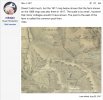
Looking at the old ordnance survey map of 1834, (LXII) the Stream that fed Witton Upper Pool rose in Oscott. This section shows the Upper and Lower Pools and a side stream from Short Heath

Witton1.png

Hawthorn Brook went onto join with the River Tame, near where there was a Reservoir made for supplying the town of Birmingham.

Witton (2).png

As to the Sparkbrook this water course started near Ladypool Road (I wonder if there is a connection with this name) and then went onto to join the River Cole.

Sparkbrook.png
 
Last edited:
I do actually know the River Eype quite Well. There a house made from a railway carriages that belonged to the chap off the Antiques Road show just up the road form the beach.

Hi,

That's brought back memories, - I remember there was at least one signal in the garden.

Kind regards
Dave
 
In the 1940s to 1960s every kid in the Great Barr/Perry Beeches area knew about and played around the 'Brook' which rose from a spring in the grounds of St Margarets Hospital. On the map below it is highlighted in blue running through Perry Beeches under the Tame Valley Canal into Perry Barr Park reservoir. From there is went under Church Road running into the River Tame near the Zig Zag bridge. We built dams on the brook, caught 'tiddlers' in it, played 'Poo sticks', jumped it and fell in, it was a big part of our young lives. I never knew whether it had an official name.

Today, parts of it run in a pipe under the M6 and it has been diverted in other places. The only people who know about it these days are those who live near the diversions suffering occasional flooding.
View attachment 150132
This brought back so many memories. That was my route home from school every day. jumping back and forth across the brook. Getting mud all on my shoes. Happy memories. I remember the pump house and wild watercress. I loved it.
 
Looking at the old ordnance survey map of 1834, (LXII) the Stream that fed Witton Upper Pool rose in Oscott. This section shows the Upper and Lower Pools and a side stream from Short Heath

View attachment 150141

Hawthorn Brook went onto join with the River Tame, near where there was a Reservoir made for supplying the town of Birmingham.

View attachment 150143

As to the Sparkbrook this water course started near Ladypool Road (I wonder if there is a connection with this name) and then went onto to join the River Cole.

View attachment 150145

“The Sparke family lived around here in the Middle Ages, but it is debatable whether the family was named after the Spark Brook or the stream took its name from the family. As a river name it may mean 'sparkling stream', though the Old English spearca usually refers to a fiery spark. There is another word spearca which means 'brushwood', and the sparrow hawk is called spear-hafoc in Anglo-Saxon, sper-hauk Middle English.

The stream runs from the Belle Walk area at the top of Stoney Lane where its source may be Bullan Wyllan, 'Bull's Spring' mentioned as a boundary mark in the Yardley Charter of AD 972. The boundary went on tha Langan Aec, 'to the Tall Oak' which probably stood at the junction of Stoney Lane and Walford Road, and then to Mundes Dene, 'Mund's Valley' following the Spark Brook to the River Cole confluence north of Tyseley Industrial Estate in Seeleys Road at the east end of the Ackers Sports Centre.”
 
Last edited:
The Sparke family lived around here in the Middle Ages, but it is debatable whether the family was named after the Spark Brook or the stream took its name from the family. As a river name it may mean 'sparkling stream', though the Old English spearca usually refers to a fiery spark. There is another word spearca which means 'brushwood', and the sparrow hawk is called spear-hafoc in Anglo-Saxon, sper-hauk Middle English.

The stream runs from the Belle Walk area at the top of Stoney Lane where its source may be Bullan Wyllan, 'Bull's Spring' mentioned as a boundary mark in the Yardley Charter of AD 972. The boundary went on tha Langan Aec, 'to the Tall Oak' which probably stood at the junction of Stoney Lane and Walford Road, and then to Mundes Dene, 'Mund's Valley' following the Spark Brook to the River Cole confluence north of Tyseley Industrial Estate in Seeleys Road at the east end of the Ackers Sports Centre.
thanks Pedrocut
 
There's an interesting summer photographic project for someone - photographing all the brook, stream, & river junctions in the Birmingham area. There must be quite a few and one or two of the bigger ones are already on the Forum. We should have them all mapped by then :)

Maurice :cool:
 
There's an interesting summer photographic project for someone - photographing all the brook, stream, & river junctions in the Birmingham area. There must be quite a few and one or two of the bigger ones are already on the Forum. We should have them all mapped by then :)

Maurice :cool:
There is a video on Youtube of a gentleman who walked the Plantsbrook/Ebrook from Sutton park - Penns hall- Pype Hayes park- Plantsbrrok lakes - Chester road - Castle Vale, here it joins the river Tame and its journey north. I wander if the Tame will be culverted when Hs2 goes through this area? p.s I will try and find the video.
 
There's an interesting summer photographic project for someone - photographing all the brook, stream, & river junctions in the Birmingham area. There must be quite a few and one or two of the bigger ones are already on the Forum. We should have them all mapped by then :)

Maurice :cool:
And when they have finished, they will be able to introduce it with 21st century language.....Streaming \now

\bob
 
The Blue Plaque shown in the video for Penn’s Mill is discussed in the thread below. The actual first Atlantic cable failed.
 
The stream runs from the Belle Walk area at the top of Stoney Lane where its source may be Bullan Wyllan, 'Bull's Spring' mentioned as a boundary mark in the Yardley Charter of AD 972. The boundary went on tha Langan Aec, 'to the Tall Oak' which probably stood at as the junction of Stoney Lane and Walford Road, and then to Mundes Dene, 'Mund's Valley' following the Spark Brook to the River Cole confluence north of Tyseley Industrial Estate in Seeleys Road at the east end of the Ackers Sports Centre.”

So that would place the source in the Moseley area, I gather.

As to Lady Pool it was just a question, where the name Ladypool might mean Lady Pool. if anybody knows of an answer
 
Eric Gibson refers to "The brook" that ran from Finchley Park along the back gardens of Hurlingham Road. I believe originally it was known as Hawthorn Brook. I think Lodge pool was probably where the old prefab island is in Warren Farm Road. The ground rises quite steeply each side and the Brook is now culverted in some places that were once open.
From our adventures as small boys (I lived in Cranbourne road), The Brook as Eric says, was open along Hurlingham Road. It Went into a blue brick tunnel under the island at Sidcup Road then opened along Cranbourne road before another curved tunnel under Danesbury Crescent, then opened up along Warren Farm Road prefabs.
Back into a long tunnel, until near Elswick Road. Somewhere near there, my pal climbed up some iron steps and popped a man hole cover in someone's back garden. He was firecly beaten back down by an old lady with a broom!
It eventually joined under Finchley Road (I think), with an arm that ran out of Finchley Park and along the rec, under college Road and on to Witton Lakes.
From what I learned as a kid, it started somewhere near Rough Road reservoir., and split, at Finchley Park, one arm directed through the rec and playing fields,
the other skirting the pimple (kingstanding beacon) and through the estate.
It was a natural Brook but redirected when Warren Farm Estate was built 1929, 1931. It was straightened and curved to accommodate the shape of the housing estate. There were various pipes layed to empty storm drains, and man holes with iron steps, some in the middle of the roads.
During heavy rain it carried a huge and potentially dangerous volume of water, sometimes flooding the back gardens along it course, before emptying into Witton Lakes.
Our parents would tell us never to go down there as it might harbour Polio and Black fever. Happy days.
 
All seems quite familiar when I orientate myself. Rodwell Grove at the back of Cranbourne road and the common pool at the bottom of the now, Warren Farm Road Hill.
 
I do not think this in this thread, but reference was made in the River Cole one.
SHIRLEY BROOK. which is the boundary between Birmingham and Solihull, starts in the Sandy Hlli area near Stratford Road. It course is a tributary of the River Cole in the Priory Mill area,
 
This brought back so many memories. That was my route home from school every day. jumping back and forth across the brook. Getting mud all on my shoes. Happy memories. I remember the pump house and wild watercress. I loved it.
micheline, just reading this thread and you note about the wild watercress brought everything into focus. I remember that brook and jumping across and how clear the water was say 70 years ago. What I remember most was the wild watercress.

Thank you for this!
 
Is The Brook still there, or has it been built over I know that the allotments now further up Beeches Rd has a swimming baths built on it. I guess it is all prime building land.


Mich
 
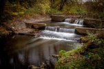
Been having a mooch down the River Cole today to photographs a couple of weirs. The one with the steppingstones was a crossing but also possibly supplied a head of water for the Hydraulic Ram at Springfield Farm.

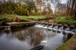
This other stepped weir is all that remains of the head race to Hay Hall Mill.

Hay-Hall-Mill.jpgHydrilic-Ram.jpg
 
The stepping stones just up from Green Road Ford in the second photo get blocked easily. If a branch floats down it is easy for it to jam across the stones and a blockage builds up. I have seen them with a very small trickle of water and the top section quite full.
 
Last edited:
Back
Top