• Welcome to this forum . We are a worldwide group with a common interest in Birmingham and its history. While here, please follow a few simple rules. We ask that you respect other members, thank those who have helped you and please keep your contributions on-topic with the thread.

    We do hope you enjoy your visit. BHF Admin Team

Old street pics..

I agree taken from Washington Street as you can see shadow of St Thomas' Church. I would say post war but probably earlier than 1950 as last tram to Ladywood ran 1947
 
Thanks a lot this is the closest I have seen to my wife's family home 236. The house's shown Mr and Mrs Yardley in one and Mrs Bolton next to the café. There was a shop just before these house's then my wife's family home, once again thank you
 
I used to send mail from work to an address in HollowayHead it sounded unusual to me for a street name. It was probably an advertising agency or an art studio of some sorts. That would have been in the 70's. It i noticably nice that you refer to your old neighbours as Mr & Mrs so and so as we all used to do.
 
A nice view of Cole Bank Road in 1925 showing Sarehole Mill. The current Mill on the site dates from 1771 and was built to grind corn, but has been used for various other purposes, Matthew Bolton even converted it at one time to work metal. The mill fell out of use about 1919 and of course they wanted to demolish it when it fell into disrepair when a local campaign forced restoration in 1969. Today it is one of only two working Mills within the boundary of Birmingham.
 

Attachments

  • Hall Green Cole Bank Rd c1925.JPG
    Hall Green Cole Bank Rd c1925.JPG
    158.6 KB · Views: 68
A nice view of Cole Bank Road in 1925 showing Sarehole Mill. The current Mill on the site dates from 1771 and was built to grind corn, but has been used for various other purposes, Matthew Bolton even converted it at one time to work metal. The mill fell out of use about 1919 and of course they wanted to demolish it when it fell into disrepair when a local campaign forced restoration in 1969. Today it is one of only two working Mills within the boundary of Birmingham.
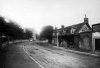
Thanks Phil. It looks so very rural. Sarehole Road started at Stratford Road in the 1920s but did not extend to Cole Bank Road until 1933. It would then run across and in front of your picture. I guess the surface and width of Cole Bank Road would then start to change to accommodate the extra traffic from nearby households. Dave
 
Just a vain hope! My dad who is now 86 used to live in a back-to-back house in Green Lane, Small Heath, directly opposite to the Public Library and Baths which is now a Mosque.

The fronts of the houses were still in place I think in the early 80's and I would love to get him a photo if I can.

Thank you

Malcolm Robinson
 
This is a photo of some houses on Park Street that ran from Masshouse Lane to the Bullring. Can anybody tell me anything about these houses, they seem to be a converted church even down to the miniature cemetery in the garden (if that's what it is)? There is even some sort of a head & shoulder bust on the wall between the houses. Sorry but I don't even know if these are street fronting or if they are in a back court.
 

Attachments

  • Deritend Park St.jpg
    Deritend Park St.jpg
    262.4 KB · Views: 81
what an unusual photo phil..i think that is washing hanging on the left hand side which would indicate that its a shot of the back of the house..the monument in the railed off area is very interesting..could it be the tail end of a churchyard...the cobbles at the forefront and the plants pots also may indicated a shot of the back of the house...

maybe if mike sees this post he may have a map to post showing the layout of park st..
 
I am not an expert here but lots of people had to hang their washing at the front too. My aunty in Doncaster did as she didn't have a back only an outside loo. That was in the 60's. They do it in the high rise flats here too still. Lovely building in your photo but sometimes envokes a sadness in how people lived.
 
Phil
I think they may have been Lench's Almshouses. The 1845 PO directory lists some between nos 81 & 82 Park St, though they are not mentioned in the 1855 edition. They would have been in the red area on the map, close to the building numbered 82. Pye's "description of modern Birmingham" says there were 4 Lench almshouses in Park St.Apparently they houses 32 persons. The 1828 and 1839 maps mark them, but are not very clear as to the footprint, in fact are not very clear which are the almshouses, as they seem to be set back.

map_c1889__site_of_lenches_almshouses.jpg
 
Mike,

Your explanation of the Park Street Building looks to be about the best we are going to get, Although the houses are not specifically mentioned in the trust history I was wondering if they might have backed on to William Lench's original tannery on Moor St and the monument and bust on the house might be something to do with the man himself?


Another good old photo, the junction of Bordesley Green, Bordesley Green Road, Cherrywood & Victoria roads. Can anybody tell me what the bell is about on the central building.
 

Attachments

  • Bordesley Bordesley Green.JPG
    Bordesley Bordesley Green.JPG
    88.6 KB · Views: 82
Phil

I agree that is very likely . The older maps seem to show the alsmhouses down an alley, so they might have been fairly close towards Moor St.

The block at the junction was called Bell Buildings as seen below. I suppose the outline of the building is bell-like from the side, but don't know if there is any other reason for the name, like being the old site of a Bell founder or owned by someone called Bell.

map_c_1889_Bell_buildings_bordesley_green.jpg
 
Mike

The bell theory looks very sound, (sorry about the pun). It does look like a bell doesn't it?
 
A not very often seen on the forum Smithfield Street that ran from Digbeth to Bradford Street, this was taken in 1953.
 

Attachments

  • Digbeth High St - Smithfield St 1953.JPG
    Digbeth High St - Smithfield St 1953.JPG
    132.1 KB · Views: 112
The following has some reference to Lench's Trust and almshouses in Park Street.

A second set of almshouses was built by the trust in Steelhouse Lane in 1688. Both this and the Digbeth set were abandoned, and new almshouses built on a site adjoining the old one in Steelhouse Lane in 1764. Further almshouses were built in Dudley Street in 1801 and in Park Street in 1815 and 1820.

https://www.british-history.ac.uk/report.aspx?compid=22986#s59


Janice
 
#3714, a very interesting topic, not only opening a vista into how the poor were housed but also some historical information on how some streets became named, thank you very much for posting. paul
 
hay mills red hill postcard.jpgThe caption on this postcard just says Redhill which is a stretch of Coventry Road in Hay Mills anyone recognise the view . The grocers seems to be called Schell
 
Hi Lynn
What year are you putting that photo up as can you say roughly ,or do you know
I wish I had a pound for every time I walked up and down that road the little black door you can see on the right hand side
As you walk down to the abbey street on the right hand side when you come to the .little jeep the little door of that house is where my dear old friend
Was mickys house and his family I spent hours in there with him and his family he later in years became a foreman for Solihull roofing
Those was great days and great memories for me Lynn. ,best wishes Alan,,,astonian,,,,
 
Just around the corner to the right, next to the white building, was a small garage with, as I remember it, only a single petrol pump. In the 1950s the word would go around that conkers were for sale there. It seems the family had a farm in the country where these coveted items actually grew on trees and were collected by the sackful to sell to us urchins for a few pence.
 
Back
Top