• Welcome to this forum . We are a worldwide group with a common interest in Birmingham and its history. While here, please follow a few simple rules. We ask that you respect other members, thank those who have helped you and please keep your contributions on-topic with the thread.

    We do hope you enjoy your visit. BHF Admin Team

Newspapers : From Birmingham Post 150 years ago

In the late 1940s all us local kids had got a big slide going on the Beeches Pub car park when the local constable suddenly appeared. It was no good running away because he knew us all and we had to stand there and receive a stern lecture before he made some of us go and get some ashes to throw on the slide.
 
1.2.1865

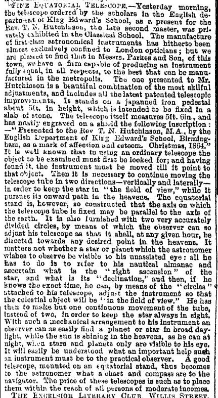
Birmingham firm into making telescopes.
Dudley charity gives out free loaves to deserving widows - does sound a bit like something from tudor times

telescope_by_brum__manufacturer.jpg


bread_for_widows.jpg
 
I remember the Convent on Hagley Road, where old people would form a cue outside the gates , and mom told me they were cueing for bread. Paul
 
This might be a similar telescope, available in different heights. - Parkes & Co exhibited this one at the 1863 International Exhibition. Interesting that the English Department presented it to him and not a scientific department. Viv.

ImageUploadedByTapatalkHD1422784141.589106.jpg
 
7.2.1865

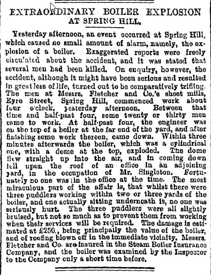
Boiler explosion in Spring Hill sends top of boiler up in the air, but causes no serious injuries

boiler_exploasion_at_spring_hill.jpg
 
interesting report about the boiler explosion mike...as it says it could have been far worse...

lyn
 
Had to Google 'puddler'. For those who don't know here's the Wikipedia definition:

"An iron puddler or (often merely puddler) is an occupation involved in the manufacture of iron. The process of puddling was the occupation's chief responsibility and involvement. Puddling was an improved process to convert pig iron into wrought iron with the use of a reverberatory furnace."

It seems puddlers had very short lives, often only living into their 30's. Interesting that there was an insurance company specifically for boilers, must have been a fairly common problem. Viv.
 
The boiler insurance companies had only just started in the last few years after a lot of boiler explosions. The company sent round inspectors each year to check the boilers out to ensure they were safe, and, assuming ther inspection was OK, then they paid forn reploacment ifn there were explosions
 
8.2.1865

From report of the public works committee. It seems like this is the date that River St, Lower hospital St, Latimer St and Floodgate st came into existence

new_streets.jpg
 
9.2.1865

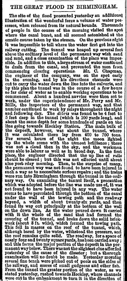
Flood from canal in Birmingham puts rail line under water. This is the initial part of the report, which is rather long.

A notice warning people not that a man will not be responsible for his wife's debts, but not to trust her (which presumably includes running up debts). An unusual way of putting it .


birmingham_flood_from_canal__part.jpg


dont_trust_my_wife.jpg
 
10.2.1864
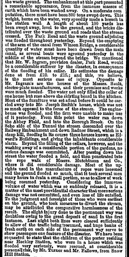
Further news of the effect of the flood in Birmingham.
Another boiler explosion, though only two injured.


great_birmingham_flood_1.jpg


great_birmingham_flood_2.jpg


boiler_explosion_in_richard_st.jpg
 
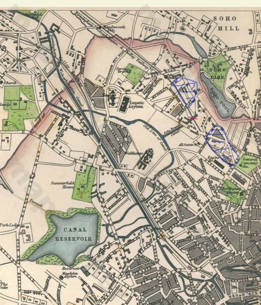
Its a bit difficult to determine exactly how much was flooded (though the full first report is longer than the extract I gave), but here is what I think the flood covered, though some areas may have been missed off. The leak in the canal is marked with a red X ands the areas I think were flooded are marked in blue on this c 1866 map

area_round_soho_1866_showing_approx_area_of_flood.jpg
 
Thanks for that Mike, very graphic. I can now see why such a large area was affected given the volume of water already around in the pools, reservoir and various canal branches in that relatively small area. Must have been a race against time to divert the massive volume of water, but to where? Surprised there weren't lots of human casualties. Viv.
 
The soho branch was emptied, and a lot more came from theb old main line. The line was blocked by planks by Winson bridge, which I assume must mean where winson green road crosses the canal, though much must have got through vefore they blocked it. No mention is made as to how far it drained from the direction of town. there don't seem to nbe any locks fro quite a way, so it must have been a lot. The water from the soho end of the breech drained to the borough brook, whereever that may be, the water from the hockley side eventually went into the Hockley brook
 
Something I learned from the map provided by Mike is that Monument Road only went as far as Icknield Port Road. The remaineder to Spring Hill is called Icknield Street West and beyond Spring Hill towards Hockley is Icknield Street East. Which poses the question:
did Icknield Street West originally continue westwards and if so when did the name Monument Road come into use.
Answers awaited from Brummie historians. :friendly_wink:
 
Monument rd was from the ivy bush all the way down to spring hill library at spring hill
Once crossing the junction of spring hill and then as you got to the library it became ickneild street all the way down to the brook
I was brought up on it Astonian,,,
 
There are no locks all the way from near Wolverhampton on the New Main Line and Smethwick on the Old Main Line to Gas Street Basin and Farmers Bridge. That is a lot of water all of which could have been emptied if they has not put the stop lock in quickly.
 
Monument rd was from the ivy bush all the way down to spring hill library at spring hill
Once crossing the junction of spring hill and then as you got to the library it became ickneild street all the way down to the brook
I was brought up on it Astonian,,,

That was how I remember Monument Road in the 1950's. However, the map of the flood. posted here by Mike, shows that Monument Road only ran from the Ivy Bush to Icknield Port Road.
So my question still remains unanswered.
 
It actually came all the way down passing ickneild port rd on the corner of ickneild port red was the deeds leap pub
Continue along passing was the old midland bank on the same corner of ickneild port red I worked in ickneild port red so I know which
Was icneild port red continue you down to monument road railway station which was previously named in its hey day
Monument lane railway station and siding and the station pub was back g it as well come down passing the barber shop passing
The original welfare centre And the few shops was king Edwards rd right on that corner where I was brought up continue across the road still walking g
Passing ingle by street and the old big ballroom down to the corner of that was the turf pub and you was at spring hill
Cross over to the library and walk past there that's where the change over was to ickneild street west and the street sign
Was afix to the lower wall of the library by 1957 it changed completely they renamed it without the west bit to the plate
And all the way down to the brook it was ickneild street
I have got an very old picture of spring hill before it change in 1957 I will try and dig it out and post it if nessary
Astonian,,,,,
 
The Godfrey 1914 reprint of the OS map shows Monument Road running from the Ivy Bush to Spring Hill as Alan (Astonian) says. So sometime before that the names changed. Just to add to the confusion, my parents always called Monument Road, Monument Lane and I still think of it as that. Today if you were to drive along it from the Ivy Bush at Gamgee House just before St Johns Church you would go onto Alston Street ( the continuation of Monument Road is a dead end) then left on to Ladywood Middleway and would then run alongside the remains of Monument Road until the canal and railway bridge and on down to Spring Hill.

Icknield Street is named after the old Roman Road as the first Birmingham historian William Hutton (1723-1815) mistakenly thought that it ran this way.
 
As you will know, David, the railway station and locomotive depot was named Monument Lane so it is most likely lots of folks knew it by that name. Where I live there were many names of places that were unofficial and would not be found on any map. These names, over time, were given by people to illustrate their facilities or location. Sadly, as older people who used these names pass on and newcomers swell the population, many are but just a memory.
 
Hi David
Yes you are correct and precise I remember the old area of lafywood as I said last week on one of the threads
I have seen the whole of Ladywood being destroyed and rebuilt through out
As a kid growing up in Ladywood virtually every street in Ladywood I have stomped before you got to the st johns church
You had Alston street on the fork of the road and the old Ladywood copper shop and police station and of course resovoir
Rd but where you call it a dead end there was the continuation of monument rd and as you said you are aimed at old Alston street
And the under takers was on that fork of the old road if you traveled through that dead end there was shops of alkinds both sides of that section
Right up to the church but as you know they built a silly ring red so you have to go on along Alston red and back to monument
Red where they built the fire station which was never there all those years ago but the old baths was there come down as you say it was monument red
But when you hit the canal bridge and the railway station for that short distance of a little stretch possible 400 yards to the train station
That bridge was monument red but soon as you pass it and cross cope street corner the station pub was there and that's where it said again monument red
If you went down cope street down along the side of it you came to a big opening which took you into the tran sheds
And inside there is a road dirt track now with the orinigal street name plate called monument lane but back up the hill and to the station pub
That's monument red and down to spring hill its self at the junction
Along to the left of the junction is and was springhil area turn to your right and walk its summer hill and towards the San Pitts
And the parade of the city but when you reached the library steps it was titled ickneild street west it was 1957 when they removed the ending title of the west
And also the lane off monument rd and it was titled was monument road
I have said I have Arnold book with spring hill in and it was 1957 before they improved the junction of the roads
Which. Certain structers within the middle of the road a d removed tracks from the road
Your instructions was bang on David with your discriptionbest wishes Alan,, Astonian,,
 
Radiorails
This is not entirely clear. Cornish's 1864 map shows Monument LANE going from Hagley Road to Reservoir Road, and past that it being Icknield Road West. However Tallis's 1866 map shows Icknield Road West going down to Plough and Harrow Road, the last length down to Hagley road not having a name on it. This could mean he included it as part of Icknield Road West, or just did not put a name on it. WE have already seen that the 1866 map shows the junction was Icknield prot road. !!!??
Early Directories are not clear. They all back to 1845 list a Monument Lane, but do not make it clear exactly where that ended and Icknield st west started. Then in 1867 the directory Monument Lane it is from Hagley Road to Reservoir Road. this remains up to 1876, but in 1878 the name is now Monument Road and it includes all what was Icknield st west (under Icknield st west it states " now Monument Road")
 
great read about the flooding mike...have this earlier map and looking at your x marks the spot it looks like was the canal basin that burst...strange you should post that snippet as i have been researching that area this week..will print and add it to my old end folder..thanks mike
 

Attachments

  • Soho%20Map%20(2).jpg
    Soho%20Map%20(2).jpg
    115.7 KB · Views: 18
Last edited:
Many thanks for your input Mike. I would not liked to have been the postman back in those confusing days. :rolleyes:

I may look at the Old Ladywood site later and see if there is anything more info there.
 
A fantastically good write up, of this serious fire, a good read , and with the detail easy for me to see in my minds eye over a hundred odd years later, thanks for posting.Paul
 
Back
Top