Pedrocut
Master Barmmie
Speculation…
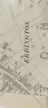
The rate book is hard to read without zooming, but if we take a range between numbers 110 and 160 on the High Street the rateable value changes and could probably indicate which were frontages. Those of low rate being the ones to the rear.
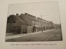
Around 110-129 are marked houses and relatively low rates. (Maybe the ones shown by Janice/Viv). Then at 130 the value goes up with marked RetailShop/House.
The rate book is hard to read without zooming, but if we take a range between numbers 110 and 160 on the High Street the rateable value changes and could probably indicate which were frontages. Those of low rate being the ones to the rear.
Around 110-129 are marked houses and relatively low rates. (Maybe the ones shown by Janice/Viv). Then at 130 the value goes up with marked RetailShop/House.
Last edited: