
-
Welcome to this forum . We are a worldwide group with a common interest in Birmingham and its history. While here, please follow a few simple rules. We ask that you respect other members, thank those who have helped you and please keep your contributions on-topic with the thread.
We do hope you enjoy your visit. BHF Admin Team
You are using an out of date browser. It may not display this or other websites correctly.
You should upgrade or use an alternative browser.
You should upgrade or use an alternative browser.
High Street Erdington
- Thread starter gingerjon
- Start date

Pedrocut
Master Barmmie
Speculation…
The rate book is hard to read without zooming, but if we take a range between numbers 110 and 160 on the High Street the rateable value changes and could probably indicate which were frontages. Those of low rate being the ones to the rear.
Around 110-129 are marked houses and relatively low rates. (Maybe the ones shown by Janice/Viv). Then at 130 the value goes up with marked RetailShop/House.
The rate book is hard to read without zooming, but if we take a range between numbers 110 and 160 on the High Street the rateable value changes and could probably indicate which were frontages. Those of low rate being the ones to the rear.
Around 110-129 are marked houses and relatively low rates. (Maybe the ones shown by Janice/Viv). Then at 130 the value goes up with marked RetailShop/House.
Last edited:

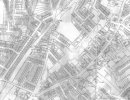
I show below the 1937 map . As before the site is at a join. It would seem that the magnification on the two sheets is very slightly different, and so cannot make a very good join, but it does look as if there is some sort of courtyard. It should be remembered that the revisions around 1900-1913 are partial revisions of the 1880s map, and some changes may not be recorded.

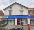
Correction to my post #391. Apologies, but The Lindens was at #163-#165 and this (see Streetview) would have been the position (today Betfred). It seems to have Victorian features above the shop. It, along with many other properties, was owned by the Machin family.
Below is an auction notice of all their properties, and it includes 20 two storey Easy Row cottages numbered #115- #153 (this refers to High Street numbering), We're given the measurements of the total frontage (nearly 70 yards and area of 4,720 square yards). This lot takes some working through, but we might find some more useful pointers.
It doesn't say specifically if the 'ancient' cottage was owned by the Machins, or that it was included in the numbering of #115-#153, but there's a good chance it was owned by them given that George H Machin took possession of the tollgate board found in the old cottage. As church warden he then passed it on to Canon Swindell.
Source: British Newspaper Archive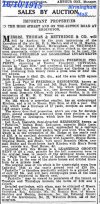
Below is an auction notice of all their properties, and it includes 20 two storey Easy Row cottages numbered #115- #153 (this refers to High Street numbering), We're given the measurements of the total frontage (nearly 70 yards and area of 4,720 square yards). This lot takes some working through, but we might find some more useful pointers.
It doesn't say specifically if the 'ancient' cottage was owned by the Machins, or that it was included in the numbering of #115-#153, but there's a good chance it was owned by them given that George H Machin took possession of the tollgate board found in the old cottage. As church warden he then passed it on to Canon Swindell.
Source: British Newspaper Archive
Attachments
Last edited:

i thought it was viv but was not sure enough to say so...thanks for the correctionCorrection to my post #391. Apologies, but The Lindens was at #163-#165 and this (see Streetview) would have been the position (today Betfred). It seems to have Victorian features above the shop. It, along with many other properties, was owned by the Machin family.
Below is an auction notice of all their properties, and it includes 20 two storey Easy Row cottages numbered #115- #153 (it refers to High Street numbering), We're given the measurements of the total frontage (nearly 70 yards and area of 4,720 square yards). This lot takes some working through, but we might find some more useful pointers.
It doesn't say specifically if the 'ancient' cottage is owned by the Machins, but chances are it is I suspect.
Source: British Newspaper Archive View attachment 215605
lyn
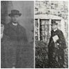
Could it be Canon Swindell outside the old cottage? Can't be sure but a possibility.
A couple of other bits and bobs I've found out. George Machin was a Director of the First Aston, Handsworth, and Erdington Model Building Society in 1897.
The Machin family had a small brick making business. In 1890, G H Machin (named as brick maker) owned the Six Ways Tea Warehouse, Erdington for which he acquired a licence.
I think he also served on the local council.
So on the face of it, Machin was very involved in the local community. But as a businessman, he also had a vested interest in building projects and the financing of them
The Machin family had a small brick making business. In 1890, G H Machin (named as brick maker) owned the Six Ways Tea Warehouse, Erdington for which he acquired a licence.
I think he also served on the local council.
So on the face of it, Machin was very involved in the local community. But as a businessman, he also had a vested interest in building projects and the financing of them
Last edited:
I think this (blue dot) was #163 - #165 High Street and named The Lindens. If so, it means Woolworths was built over the passageway to the right of the Lindens.
Barnabas Road was built directly alongside the line of the NE edge of this building (red dot). So this building position would have been covered over when Woolworths built it's store. Therefore, was this structure (red dot) the old 'ancient' cottage in Benjamin Stone's 1890s photo ?
The only other alternative for the old cottage position would be the building just to the south (yellow dot) where the land was also built over for the Woolworth store.
If you use Lyn's mapping tool link in post #382, you'll see what I'm trying to explain- hopefully!
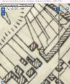
Barnabas Road was built directly alongside the line of the NE edge of this building (red dot). So this building position would have been covered over when Woolworths built it's store. Therefore, was this structure (red dot) the old 'ancient' cottage in Benjamin Stone's 1890s photo ?
The only other alternative for the old cottage position would be the building just to the south (yellow dot) where the land was also built over for the Woolworth store.
If you use Lyn's mapping tool link in post #382, you'll see what I'm trying to explain- hopefully!
Last edited:
Pedrocut
Master Barmmie
I think this (blue dot) was #163 - #165 High Street and named The Lindens. If so, it means Woolworths was built over the passageway to the right of the Lindens.
Barnabas Road was built directly alongside the line of the NE edge of this building (red dot). So this building position would have been covered over when Woolworths built it's store. Therefore, was this structure (red dot) the old 'ancient' cottage in Benjamin Stone's 1890s photo ?
The only other alternative for the old cottage position would be the building just to the south (yellow dot) where the land was also built over for the Woolworth store.
If you use Lyn's mapping tool link in post #382, you'll see what I'm trying to explain- hopefully!
View attachment 215615
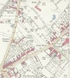
Here is the OS 25 in Map surveyed in 1888 which gives a little more detail.

Lady Penelope
master brummie
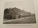
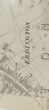
Apologies for the standard of these photos of Easy Row - The photo is taken from Saxton's Bygone Erdington and the map is from Birmingham Library. Easy Row is just at the bottom of the map, disappearing onto the next one. Barnabas Road wasn't there then.
Attachments
Great, thanks Pen. Not how I imagined it, I must say !
Lady Penelope
master brummie
Janice post #412 shows Easy Row much clearer than my map. I think Easy Row was definitely on the High Street not at the rear. There are more buildings behind the Row so I'll see what Saxton has to say on the subject. I'm taking the book back this evening so will have a look before then.
Pedrocut
Master Barmmie
Turning Lady P’s map round the street coming in on the left is New Street, so we are moving some way from Woolworths and Barnabus Road.
The further you go back in time the more distinct Easy Row becomes, until around 1910 when the numbering was encorporated into High Street.
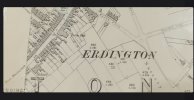
The further you go back in time the more distinct Easy Row becomes, until around 1910 when the numbering was encorporated into High Street.
Lady Penelope
master brummie
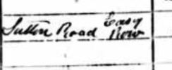
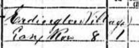
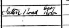
Hi Janice, I hadn't seen Sutton Road with reference to the High Street before but it was the road to Sutton so I suppose that makes sense. Especially when you look at the by-pass which was named 'New' Sutton Road.
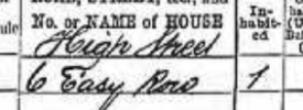
Pedrocut
Master Barmmie
The question about Sutton Road is interesting as it looks to get a mention some 20 odd years after High Street.
If you look on the OS Maps…In 1887 High Street extended up to the Old Chester Road. On the 1902 OS High Street extends to somewhere near Erdington Abbey and becomes Sutton Road up to the Chester Road.
If you look on the OS Maps…In 1887 High Street extended up to the Old Chester Road. On the 1902 OS High Street extends to somewhere near Erdington Abbey and becomes Sutton Road up to the Chester Road.
Last edited:

Agree, the same capping ! If so it would suggest Stone was looking down the passageway from High Street towards the old cottage. Which fits with maps we've looked at.
Just an idea. But could the row of cottages in LadyPs photo in post #428 just have been named Easy Row although they were actually on High Street. To illustrate, when we've looked at address plaques, court names etc, on houses and entrances to courts on another thread, the plaque/court name didn't necessarily appear on maps. They were just names given to the houses/buildings. And sometimes they referred to multiple houses/buildings in a group. The name of the actual road and building number would appear but not always the name displayed on the plaque.
Hopefully you get my drift.
Hopefully you get my drift.
Last edited:
thats possible viv...they were certainly on the high st as we can see lamp posts and what looks like tram lines..Just an idea. But could the row of cottages in LadyPs photo in post #428 just have been named Easy Row although they were actually on High Street. To illustrate, when we've looked at address plaques, court names etc, on houses and entrances to courts on another thread, the plaque/court name didn't necessarily appear on maps. They were just names given to the houses/buildings. And sometimes they referred to multiple houses/buildings in a group. The name of the actual road and building number would appear but not always the name displayed on the plaque.
Hopefully you get my drift.
Yes, Lyn.
What would be interesting to know is how they came to be called/known by the name of 'Easy Row'.
What would be interesting to know is how they came to be called/known by the name of 'Easy Row'.
i agree viv...i am just grateful that we have a photo of easy row..but yes to know how they came to be called that would be very interesting..Yes, Lyn.
What would be interesting to know is how they came to be called/known by the name of 'Easy Row'.
lyn
For comparison. The blue line is approximately where Barnabas Road was cut through.
I think the railings to the left must be the front garden of Mr Machin's The Lindens. Its now retail units at street level, but looks, at the time of the photo to be an entrance to a completely residential building.

I think the railings to the left must be the front garden of Mr Machin's The Lindens. Its now retail units at street level, but looks, at the time of the photo to be an entrance to a completely residential building.
Last edited:
does anyone have a date for the photo of easy row cottages
lyn

pjmburns
master brummie
That's the point I was making in post 433Just an idea. But could the row of cottages in LadyPs photo in post #428 just have been named Easy Row although they were actually on High Street. To illustrate, when we've looked at address plaques, court names etc, on houses and entrances to courts on another thread, the plaque/court name didn't necessarily appear on maps. They were just names given to the houses/buildings. And sometimes they referred to multiple houses/buildings in a group. The name of the actual road and building number would appear but not always the name displayed on the plaque.
Hopefully you get my drift.