-
Welcome to this forum . We are a worldwide group with a common interest in Birmingham and its history. While here, please follow a few simple rules. We ask that you respect other members, thank those who have helped you and please keep your contributions on-topic with the thread.
We do hope you enjoy your visit. BHF Admin Team
You are using an out of date browser. It may not display this or other websites correctly.
You should upgrade or use an alternative browser.
You should upgrade or use an alternative browser.
Gosta Green Through Duddeston
- Thread starter GER22VAN
- Start date
brumgum
Proud to be a Brummie!
That's smashing Mike, thanks for that.Brumgum
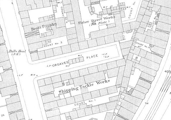
Map attached, but, as i said, can find little mention in directories
mike
brumgum
Proud to be a Brummie!
Have just realised i can do a bit better. It hadn't registered that it would be on this larger scale map
mike
That's a great map Mike, My Dad tells me that two generations of his family the Hines-Randles lived at the bottom house on the left, he will be very happy to see this!.
Can you help me look for another location in Aston Rd just at the back of here. My Grandparents were on the 1911 census and the address was 23ct 3ho Aston Rd, i'd love to find out where this exactly was and i can see fron your map it has some numbers on,
thanks,
Brumgum.
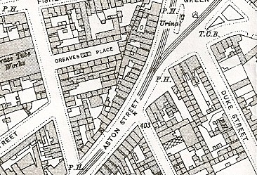
Unfortunately the very large scale map I have only covers a very small area of the south end of Aston road, but it does list courts 24 & 25. i;ve marked those on the smaller scale map attached. As they run consecutively, then almost certainly court 23 is on the western side of Aston road, in the small triangle of buildings north of Digby Street. trouble is its difficult to tell what is a court of houses and what are outbuildings or workshops attached to the back. sorry I can't be of more help.
mike
mike
brumgum
Proud to be a Brummie!
Thanks for your help, sorry i didn't reply but i've been away,Unfortunately the very large scale map I have only covers a very small area of the south end of Aston road, but it does list courts 24 & 25. i;ve marked those on the smaller scale map attached. As they run consecutively, then almost certainly court 23 is on the western side of Aston road, in the small triangle of buildings north of Digby Street. trouble is its difficult to tell what is a court of houses and what are outbuildings or workshops attached to the back. sorry I can't be of more help.
mike
Brumgum.
brumgum
Proud to be a Brummie!
I'm trying to imagine what it would be like living in one of these courts. My Nan had just had her first child in the 1911 census and she lost this daughter and another within 8 hrs of each other later on. On the census they just had one room. She lived in various locations in this area untill 1955 when she moved in with my parents.Unfortunately the very large scale map I have only covers a very small area of the south end of Aston road, but it does list courts 24 & 25. i;ve marked those on the smaller scale map attached. As they run consecutively, then almost certainly court 23 is on the western side of Aston road, in the small triangle of buildings north of Digby Street. trouble is its difficult to tell what is a court of houses and what are outbuildings or workshops attached to the back. sorry I can't be of more help.
mike
brumgum
Proud to be a Brummie!
Must have looked something like this i found on another thread..I'm trying to imagine what it would be like living in one of these courts. My Nan had just had her first child in the 1911 census and she lost this daughter and another within 8 hrs of each other later on. On the census they just had one room. She lived in various locations in this area untill 1955 when she moved in with my parents.
https://forum.birminghamhistory.co.uk/attachment.php?attachmentid=20229&d=1222811320
A
ANDY HUTCHINGS
Guest
does anyone remember the old train engine in the park?used to play on that as kids
Phil
Gone, but not forgotten.
Hello Andy
If you mean the one in Newdegate street on the end of Vauxhall Rd, then I never played there myself, as I was too old by the time this park opened. Anyway if thats the one you are talking about here's a photo.
Phil
If you mean the one in Newdegate street on the end of Vauxhall Rd, then I never played there myself, as I was too old by the time this park opened. Anyway if thats the one you are talking about here's a photo.
Phil
Attachments
paul spedding
knowlegable brummie
Hello I'm from Dan Pawsons Artesian Hall Stompers who used to play at "The Warwick Castle " Gosta Green in the 1960's, Has anyone got an exterior photo of the pub ? Would be great if someone has one..... Here's hoping.
Paul Spedding.
Paul Spedding.
paul spedding
knowlegable brummie
Thanks Phil for prompt reply.... Here's hoping someone can help.
Paul.
Paul.
C
colin walker
Guest
I played there in the 1960s with brothers and sisters. but what i remember most was the big factory next to it . when it closed they emtied all the army helmets from inside and all the kids in the area were walking around in them. I kept one for years till i borrowed it out for a fancy dress.
TCWARDPLUMBERS
master brummie
Ernie / phil, thats a picture, thanks terry
Phil
Gone, but not forgotten.
The thing about old photo's is, they correct your mind and remind you just how things were. Prior to seeing that photo, if asked to describe Duddeston Mill Rd I never would have described the hill as being that steep.
After seeing the photo it has all come back to me, yes it was that steep, especially where it passed under the bridge.
Phil
After seeing the photo it has all come back to me, yes it was that steep, especially where it passed under the bridge.
Phil
Phil
Gone, but not forgotten.
Help needed.
I was trawling through Carl Chinns Site Birmingham Lives, when I came across the photo. Can anybody tell me where it is (get your glasses on Ernie) I have no recollection of it at all.
The caption says St Thomas Social Club and Church Hall Great Lister St 1957. I am still no wiser.
Phil
I was trawling through Carl Chinns Site Birmingham Lives, when I came across the photo. Can anybody tell me where it is (get your glasses on Ernie) I have no recollection of it at all.
The caption says St Thomas Social Club and Church Hall Great Lister St 1957. I am still no wiser.
Phil
Attachments
hi mikejee - what is the map you've shown here?Brumgum
Map attached, but, as i said, can find little mention in directories
mike
and this oneHave just realised i can do a bit better. It hadn't registered that it would be on this larger scale map
mike
Francis Street
Pedlarman. ( Jim ) I hope this map helps with Francis Street Location.
View attachment 27773
Great Frances Street can just be seen at the end of Ashted Row.
Pedlarman. ( Jim ) I hope this map helps with Francis Street Location.
View attachment 27773
Great Frances Street can just be seen at the end of Ashted Row.
Phil
Gone, but not forgotten.
Phil. I thought I knew Great Lister Street but that Photograph really has got me beaten.
Ernie
I have looked all up and down Great Lister St in Kelly's to no avail, mind you that only means the postal address could be in the side street as the photo shows it to be on a corner.
Phil
Phil. Cannot see a date on it, the other two A to Z's look newer.
View attachment 27775
View attachment 27775


![image[2].jpg image[2].jpg](https://birminghamhistory.co.uk/forum/data/attachments/34/34884-8ed9073c3463fb7f3b7d5a3cdb9c7de6.jpg?hash=jtkHPDRj-3)

