-
Welcome to this forum . We are a worldwide group with a common interest in Birmingham and its history. While here, please follow a few simple rules. We ask that you respect other members, thank those who have helped you and please keep your contributions on-topic with the thread.
We do hope you enjoy your visit. BHF Admin Team -
HI folks the server that hosts the site completely died including the Hdd's and backups.
Luckily i create an offsite backup once a week! this has now been restored so we have lost a few days posts.
im still fixing things at the moment so bear with me and im still working on all images 90% are fine the others im working on now
we are now using a backup solution
You are using an out of date browser. It may not display this or other websites correctly.
You should upgrade or use an alternative browser.
You should upgrade or use an alternative browser.
Old building Query
- Thread starter Dennis Williams
- Start date

BrummieGeoff
Sparkhill Lad
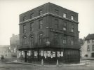
The attached photo containing the same building is tagged as Steelhouse Lane .... supporting the location as being the pink dot on the above map.
 1881.jpg")
Dennis Williams
Gone but not forgotten
And 1880s newspapers mention an E Milward at 1 Aston St.
Cheers...xxAnd 1880s newspapers mention an E Milward at 1 Aston St.
Dennis Williams
Gone but not forgotten
Brilliant sleuthing, as per on here! So grateful...
Dennis Williams
Gone but not forgotten
What year was this map please?Sign appears to say moved to the opposite corner Aston St, which was the opposite corner. Map from 1839, building (?) marked with pink dot...
View attachment 173428
Dennis Williams
Gone but not forgotten
Another puzzler...when they say MOVED to Aston Street....the building in BrummieGeof's post shows it exact....surely they woudn't move it brick by brick.etc....?
MWS
from Bham
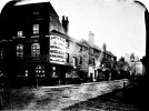
The building in the pictures is the same from 2 different angles - yours corner of Lancaster St and Lichfield St, BrummieGeoff's corner of Lancaster St and Steel House Lane. The main frontage was on Lancaster St, sides going down the other 2.
I'd guess it was knocked down when Corporation St was built and they moved to a different uilding.
I'd guess it was knocked down when Corporation St was built and they moved to a different uilding.
Dennis Williams
Gone but not forgotten
Of course! Doh! xx Thanks again...
BrummieGeoff
Sparkhill Lad
As MWS suggests, the building was probably demolished as part of the Corporation Street development .... I believe the photo I posted was taken by James Burgoyne as part of a series to record views that would be lost when Corporation Street was cut through town.
Re. photo in post #4, what are oil and colourmen ? Is to supply oil and paints ? They’re also ‘Druggists’ so could it be some sort of chemical processing ? Viv.
Last edited:
For those interested there’s a thread about James Burgoyne’s Birmingham photographs here :........... I believe the photo I posted was taken by James Burgoyne as part of a series to record views that would be lost when Corporation Street was cut through town.
James Burgoyne photographic collection
hi folks..thought it would be nice to start a new pic thread dedictated to the early 1880s photos that james burgoyne was commissioned to take by the the city council...i personally find them absolutely fascinating and they just prove how much birmingham has changed since then...over 100 where...
birminghamhistory.co.uk
Viv.
Oil and colourmen were suppliers of all sorts of chemical products, including oils, paint materials, dyes etcRe. photo in post #4, what are oil and colourmen ? Is to supply oil and paints ? They’re also ‘Druggists’ so could it be some sort of chemical processing ? Viv.
BrummieGeoff
Sparkhill Lad
I think the Steelhouse Lane photo shows a pub in the foreground .... on the corner of Lancaster Street. Does anyone know the name of that pub ?
mw0njm.
A Brummie Dude
was it the the George and DragonI think the Steelhouse Lane photo shows a pub in the foreground .... on the corner of Lancaster Street. Does anyone know the name of that pub ?

Jonob
master brummie
I think this is Joseph Gilman & Son who I think are still in business in Tyburn Rd, John.The attached photo containing the same building is tagged as Steelhouse Lane .... supporting the location as being the pink dot on the above map.
View attachment 173430
Attachments
If the date 1881 is correct, then I do not think it was then a pub, . The 1880 directory does not list one around that position./ But the 1879 edition (which probably refers to 1878) shows the Old Star at no 70 Steelhouse Lane, which would be about the right position.
Having said that, the licence of the Old Star was transferred to Edward Pickmore on 7.8.1879; then to W.Francis on 5.8.1880; to Michael McInnis on 7.10.1880; to Alfred humpage on 7.10.1881. Having said that , there was a clearout sale of furniture and bar equipment reported there on 7. 5.1880. There was an advert of sale of materials from the Old Star and adjoining buildings advertised to occur on 24.10.1881.
There seems to be some arguments as to the working of the licensing system referred to in the report below
Last edited:
BrummieGeoff
Sparkhill Lad
The attached 1887 map shows a pub on the corner of Steelhouse Lane and Lancaster Street .... the site of the Castle PH in the previous map.
However, I initially thought that the lamp attached to the building in the foreground of the Steelhouse Lane photo was the type often seen on pubs of that era .... but now I look more closely I think it has "Lancaster St" written on it. Did they use lamps like this as "street signs"?

However, I initially thought that the lamp attached to the building in the foreground of the Steelhouse Lane photo was the type often seen on pubs of that era .... but now I look more closely I think it has "Lancaster St" written on it. Did they use lamps like this as "street signs"?
Last edited:
Dennis Williams
Gone but not forgotten
Tried to overlay the earlier road layout over the 1889 map, not great but it shows how far the Castle was from the corner...
View attachment 173463
Sorry to be a pest MWS, but where on your map is our Milward's shop? Or had it gone by then....?

Dennis Williams
Gone but not forgotten
Cheers.. you are a star!It has gone by then but the green dot is where Milward's would have been, Steelhouse Lane above Lichfield St below...
View attachment 173481