• Welcome to this forum . We are a worldwide group with a common interest in Birmingham and its history. While here, please follow a few simple rules. We ask that you respect other members, thank those who have helped you and please keep your contributions on-topic with the thread.

    We do hope you enjoy your visit. BHF Admin Team
  • HI folks the server that hosts the site completely died including the Hdd's and backups.
    Luckily i create an offsite backup once a week! this has now been restored so we have lost a few days posts.
    im still fixing things at the moment so bear with me and im still working on all images 90% are fine the others im working on now
    we are now using a backup solution

OLD BIRMINGHAM PHOTOS FROM STEVEBHx

Working from home so a few for you at lunch 49A Bristol Road 1971, nice selection of cars and a couple of nice projecting sign, especially like the Wall's Icecream.

View attachment 160534
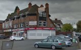
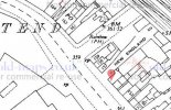
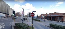
Shop still there. Went back to 2018 for this as the junction is now surrounded by traffic lights which masked the view somewhat.
 

Attachments

  • 49A Bristol Road - Edg - 2018.JPG
    49A Bristol Road - Edg - 2018.JPG
    57 KB · Views: 23
309 Marsh Lane Erdington in 1971, local betting shop and a couple of houses with nice old windows. bet that chestnut tree is a lot taller - if its still there.View attachment 160536
Houses still there but a new co-op on the site of the former shops. It was still a bookies in 2012
 

Attachments

  • 309 Marsh Lane Erdington - 2021.JPG
    309 Marsh Lane Erdington - 2021.JPG
    46.5 KB · Views: 26
  • 309 Marsh Lane Erdington - 2012.JPG
    309 Marsh Lane Erdington - 2012.JPG
    50.5 KB · Views: 26
156 High Street Deritend, 1980, good old Guinness advert, bit of a yard and some inventive guttering . thanks for looking


View attachment 160538
Another one giving me a headache. Map shows the position of 156 with The rainbow on the left. Streetview is the same section with the rainbow building still standing but 156 has gone.
 

Attachments

  • 156 High Street Deritend -  map.JPG
    156 High Street Deritend - map.JPG
    50.2 KB · Views: 24
  • 156 High Street Deritend - 2021.JPG
    156 High Street Deritend - 2021.JPG
    69 KB · Views: 24
Last edited:
Houses still there but a new co-op on the site of the former shops. It was still a bookies in 2012

The bookies was a chemist in the 1950's. All that row belonged to the Co-op, the grocers, the butchers, the greengrocers and finally the chemists. I can still remember the different smells - ground coffee, cheese and bacon in the first, sawdust in the second, fish in the third and the mystical smell of a chemist's shop in the last one.
 
I find the rapid cuts from one scene to the next very annoying. Is this a function of the equipment or just some modern fashion? I appreciate that you can pause, but there is barely even time to react before it flicks on to the next view. Horrible.
 
I find the rapid cuts from one scene to the next very annoying. Is this a function of the equipment or just some modern fashion? I appreciate that you can pause, but there is barely even time to react before it flicks on to the next view. Horrible.
Yes, I know what you mean, I don't know much about drones - could just be the way they've edited it?
 
The picture quality is excellent, and I think they try to cover a large area in a short time. Maybe the idea is that many people will stop the video at certain points and study the still picture in detail. The screenshot will show the location and the film maker.
 
I like it, but yes a bit of a quick-fire, whistle-stop tour. Most places are still familiar to me if only because I can get bearings from older buildings. The one complete mystery though is “Lakeside” - a new one on me. Where exactly is it? And what was there before? Viv.
 
I like it, but yes a bit of a quick-fire, whistle-stop tour. Most places are still familiar to me if only because I can get bearings from older buildings. The one complete mystery though is “Lakeside” - a new one on me. Where exactly is it? And what was there before? Viv.
Vivienne, it is on the Aston University Campus and, as far as I am aware, has been there for many decades, the campus having been created in the 1950s from having demolished housing and factories to make way for the College of Technology, Birmingham.

The film is good but I'd agree that it cuts away pretty quickly and doesn't allow much opportunity to dwell. Birmingham has changed so much in the last 20 years or so and is no longer the city of manufacturing it used to be.

I heard a former member of Duran Duran, Stephen Duffy, being interviewed a couple of years ago and he said the main he'd noticed when he got on a bus was that they no longer smelt of the machine oil from being on clothes of those who travelled to and from factories where they worked. Maybe that's progress but I can't help feeling we've lost so much of the industrial heritage, not to mention the reasonably well-paid jobs, as a consequence.
 
Another one giving me a headache. Map shows the position of 156 with The rainbow on the right. Streetview is the same section with the rainbow building still standing but 156 has gone.
“New England” not a road/yard/passageway I’ve heard of before. Looks like it’s now gone, probably disappeared as part of later building development. Viv.
 
“New England” not a road/yard/passageway I’ve heard of before. Looks like it’s now gone, probably disappeared as part of later building development. Viv.
1889 map shows it as "court 31" although directory entries have it as New England much earlier.
1629548845393.png
No name on 1890 map but on the next most suitable map (1904) it was called New England.

1879 directory
1629549320669.png
It just seems to be listed as New England with no names in 1905 onwards.
 
Last edited:
Next we have a picture of Ethel Street, I think I am on New Street looking down so the building on the left under construction - was there a Woolworths or similar store on the seventies?
Plenty of little vignettes - group on the corner talking , lad sat on the rail with his dad(?), also the car on the left with the L plate. Any offers on the diamond shaped sign , and I love the lorry with the motor thingy on the back ( cannot think of the name!!)

Test180 1.jpg
 
Next is an overview of the Veg market, and once you look closely there is a lot to see and going on. Frit boxes at the front, then moving round to greens, a sack of spuds on its side and boxes and crates everywhere, its only when you look closely you see all the people loading and unloading. There are also desks and glass kiosks, lorries, and all the hanging signs for the businesses.
Test217 1.jpg
 
Finally the saddest sight, unfortunately the end for many of the buildings we see in old images, strange to see the colour of the walls and the grate hanging in the air, some roofs missing and the out houses knocked down but rest of the walls standing. Very much work in progress if the man with the pickaxe is anything to go by, as usual no year or location.
Test281.jpg
 
Next we have a picture of Ethel Street, I think I am on New Street looking down so the building on the left under construction - was there a Woolworths or similar store on the seventies?
Plenty of little vignettes - group on the corner talking , lad sat on the rail with his dad(?), also the car on the left with the L plate. Any offers on the diamond shaped sign , and I love the lorry with the motor thingy on the back ( cannot think of the name!!)

View attachment 160626
The L plate car is an Austin A40 Somerset, the black saloon is a Morris Oxford Series MO, and the compressor lorry is a Bedford.
 
Back
Top