-
Welcome to this forum . We are a worldwide group with a common interest in Birmingham and its history. While here, please follow a few simple rules. We ask that you respect other members, thank those who have helped you and please keep your contributions on-topic with the thread.
We do hope you enjoy your visit. BHF Admin Team -
HI folks the server that hosts the site completely died including the Hdd's and backups.
Luckily i create an offsite backup once a week! this has now been restored so we have lost a few days posts.
im still fixing things at the moment so bear with me and im still working on all images 90% are fine the others im working on now
we are now using a backup solution
You are using an out of date browser. It may not display this or other websites correctly.
You should upgrade or use an alternative browser.
You should upgrade or use an alternative browser.
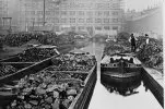
Lost Birmingham Canals
- Thread starter Heartland
- Start date

Heartland
master brummie
Re the New Steam Mill
That is part of the identification issue. There is a map of about the mid 1830's which shows it (in Birmingham Canal Navigations Society Archives) where it is next to the Honduras Wharf. This "New Steam Mill" seems to have been associated, at that time with the rolling of metals, but it did let of power to others, such as the timber wharf. In 1850 the trade directory mentions different tenants and later still it was the Eagle Flour Mill.
The Old Steam Mill was first on a plot of land near Water Street and is shown on a map of Birmingham prior to the making of the Birmingham & Fazeley Canal. It was here that James Pickard used a steam engine that was the first to adopt rotative motion. Pickard occupied property that extended from Water Street to Lionel Street and the canal bisected that property. The steam mill was developed as two separate functions, where the rolling of metals and the milling of flour was conducted. By the 1830's the Metal Rolling Mill had a separate identity to the flour mill, which by then, this flour mill was on the corner of Water Street and Snow Hill. Samuel Parker had the flour mill, then. The separate rolling mill was occupied by the Muntz family who had become known for the making of sheathing metal for ships. It was Rayner, a later occupant of the Old Steam Mill that transferred the mill to Snow Hill Wharf and the Muntz mill was finally occupied by Kynoch's until the GWR needed part of the mill site for their Snow Hill station expansion.
Parker and later Rayner had it seems little access to the canal as there was a Timber Yard, Muntz Mill and the Phoenix Foundry between the flour mill and the canal and it is possible that the Snow Hill Wharf warehouses were used to assist the Old Steam Mill trade until they moved their mill there. The mill is shown on the 1st Edition Ordnance Survey as being on Snow Hill Wharf, so the move would have been prior to this survey.
this was Baskerville wharf removed to build Baskerville house and all that green area .View attachment 117728 View attachment 117729 View attachment 117730 View attachment 117728 View attachment 117729 View attachment 117730
Yes it could prove an interesting thread. I have put three maps of the Old Wharf from around 1880, 1903 and 1913.
Attachments
A very nice study of the old Navigation Office doorway. The Office was situated near to Old Wharf and facing Paradise Street (see first map in post #4 posted by Pedrocut). Viv.

Janet Hunt
master brummie
Hello PedrocutView attachment 117770 View attachment 117771
In post 869 of the “Key Hill Cemetery” Thread it was mentioned about “Mount Misery” and the plight of the sand carriers...
https://birminghamhistory.co.uk/forum/index.php?threads/key-hill-cemetery.4830/page-44#post-590943Z
The two thumbnails show the area around Newhall Street from the 1890 OS Map, the second being the area between the four streets, Newhall St, Great Charles Street, Lionel Street and Summer Row. In this area there are at least 5 wharfs, one being “India Wharf.”
The Bridge at Summer Row is called Friday Bridge, and father down there is Saturday Bridge.
Is there any possibility of looking at the Aston junction of this map as my "relly" was a boatman and lived and worked near Mill Street Many thanks
jan
Pedrocut
Master Barmmie
Johnfromstaffs
Johnfromstaffs
Excellently drawn. This sort of work makes me very green with envy. As my old dad used to say, “you’d have trouble drawing breath.” But he was a “dratter”.A very nice study of the old Navigation Office doorway. The Office was situated near to Old Wharf and facing Paradise Street (see first map in post #4 posted by Pedrocut). Viv.
View attachment 169706
Janet Hunt
master brummie
Janet Hunt
master brummie
You are my star pedrocut