• Welcome to this forum . We are a worldwide group with a common interest in Birmingham and its history. While here, please follow a few simple rules. We ask that you respect other members, thank those who have helped you and please keep your contributions on-topic with the thread.

    We do hope you enjoy your visit. BHF Admin Team

Ford Family Garrison Lane.

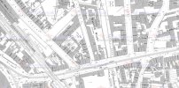
This is a map of the area from about 1916. I think the yard would have been the one I have put the red cross in.
View attachment 155660

Elsie May Ford said that her Gran and Grandad Ford lived in Henley St , Camp Hill. " They lived down the first yard from The Ship Pub. Prince Rupert stayed at the pub during a battle. The railway ran along the bottom of the yard. When you were in the house you could hear the trains rattling past. We used to go there sometimes on a Sunday afternoon and we always got a piece of seed cake. Aunt Nancy, Dad's sister, used to take us to Farm Park". Tinpot
 
Looking on Streetview at the corner pub's location which I think is The Ship, it still stands but the name had been changed at some point and it is now no longer a pub but is described as an hotel. Its exterior has been radically altered to eradicate the Victorian original features.

Here it is in 2020 - https://www.google.co.uk/maps/@52.4...wXS_QRuQ!2e0!5s20200801T000000!7i16384!8i8192

Here is as it was in 2008 when it was then called The Shakespeare. It is to give an idea of how the family may have remembered it-

https://www.google.co.uk/maps/@52.4...fmUxDtCw!2e0!5s20080601T000000!7i13312!8i6656

Do you think that this was The Ship?
 
Here is another Streetview taken from the side road showing what the view of the railway embankment might have looked like from the back of the house. Pleasingly rural I think.

 
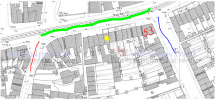
I meant to point out that Henley Street is not next to the Ship. The yard I marked is next to the pub in Henley Street but that pub was the Shakespeare. If my memory serves me correctly the blue circle is where the Ship was and the red cross is the yard in Henley street.
1617982019586.png
 
I got a bit confused with the different photographs I could find! I suppose Elsie May, at about 80 when she made these notes, could have merged them in her memories.

Samuel Ford died of TB age 48 at an address I presume is Selly Oak Hospital. Tinpot
 

Attachments

  • IMG_1742.jpg
    IMG_1742.jpg
    223.6 KB · Views: 3
I got a bit confused with the different photographs I could find! I suppose Elsie May, at about 80 when she made these notes, could have merged them in her memories.

Samuel Ford died of TB age 48 at an address I presume is Selly Oak Hospital. Tinpot
Yes 1a was part of Selly Oak Hospital from about 1928 but it was also the address of what had been Kings Norton workhouse - I think.
 
Reference the previously mentioned Shakespeare in #152 a earlier post in the Stratford Road thread
In July 1953, D.J.Norton photographed a tram on the Stratford Road passing the Shakespeare pub on the corner of Henley Street.
index.php

Recently Google photographed the place in nearly the same position.
index.php
 
Reference the previously mentioned Shakespeare in #152 a earlier post in the Stratford Road thread
That puts it all in perspective with the railway bridge included. I noticed on the maps that the tram shed was on the next road down. I have travelled on one of those trams going to Cannon Hill Park as I remember. Thanks oldMohawk
 
What a fine building it had been and the architect had given some thought to how it fitted in with its surroundings. It looked like the pub had had stained glass windows and the external ornamentation had been designed to echo the spire on the other side of the railway line. I notice that the Victorian street sign has been retained on the wall.
 
Strangely, it looks older now than it did then. Could it be the building on the right in the left hand photo taken from a different angle?
 
The Ship is the large building in the centre of the left photo on the very sharp junction. The second photo shows it no longer exists. This is the pub in the blue circle on my map in post #154
It is not near the Shakespeare on the corner of Henley Street.
 
I got a bit confused with the different photographs I could find! I suppose Elsie May, at about 80 when she made these notes, could have merged them in her memories.

Samuel Ford died of TB age 48 at an address I presume is Selly Oak Hospital. Tinpot
There is a daughter, I believe of Emma Ford and Samuel Ford but could be Emma and George , who was referred to as Emily and having died young with diphtheria. Any information would be appreciated.
 
Emily born 1927. So must be daughter of Emma and Samuel. Birth registered with mmn Crumpton in last quarter.
There is a possible death registered in 1936 in 3rd quarter - child aged 8.
1618310537739.png
Possible burial at Yardley
 
Last edited:
Emily born 1927. So must be daughter of Emma and Samuel. Birth registered with mmn Crumpton in last quarter.
There is a possible death registered in 1936 in 3rd quarter - child aged 8.
View attachment 155870
Possible burial at Yardley
Thanks Janice. These deaths with TB and diptheria are a reminder of how important vaccines have been for people's life chances. Alongside the move to better municipal housing.
 
Going back to the Garrison Lane connection, on the forum David Trevor Help entries #100 & #101 I have posted information about siblings of a Victorian stage celebrity called David Trevor who took turns to run The Garrison pub not long after it first opened in the 1860s. It describes what was going on there. In case it is of any interest.
 
Going back to the Garrison Lane connection, on the forum David Trevor Help entries #100 & #101 I have posted information about siblings of a Victorian stage celebrity called David Trevor who took turns to run The Garrison pub not long after it first opened in the 1860s. It describes what was going on there. In case it is of any interest.
Thanks Susan. I had read some of your earlier posts on David Trevor but I see you have added quite a lot of detail over the weekend that I will also read. It's a fascinating story and must have taken quite some time to research and put together. Tinpot
 
There is a daughter, I believe of Emma Ford and Samuel Ford but could be Emma and George , who was referred to as Emily and having died young with diphtheria. Any information would be appreciated.
I have got a bit further back with the Ford family to another Samuel Ford born around 1830 in Charlton Kings, Cheltenham who at one point lived at Green Lane, Little Open Terrace, Aston and also in the 1861 census he lived at 46 Coventry Road working as a gas labourer. Is this the Green Lane in Small Heath? Also I don't know exactly wherabouts 46 Coventry Rd would be? Any help would be welcome. Tinpot
 
Without a suitable old map of Birmingham, this is only guesswork Tinpot but I believe that 46 Coventry road which technically runs from Birmingham to Coventry would have been in Small Heath near Digbeth near the numbering start of the road. Even as a child, the house numbers already ran into the 1000s not far beyond Yardley. Forty six might have come under the auspices of Aston as it was the registration district for births, deaths and marriages for some people living in Small Heath in at least Edwardian times even though it was not Aston per se. The road layout in that area has been changed beyond recognition I suspect. Green lane Small Heath would have been very close by. Let's hope that someone has an old OS map.
 
Your Samuel Ford was discussed on page 3 of this thread.

The earliest that numbers are on maps is 1950. Here is a map from 1889, there have been some changes between the two dates but the Clement's Arms is still in the same place on the corner of Coventry Road & Lower Trinity St. In 1950 it is listed as number 30. So if it is the same number in the 1860s then 46 would have to be to the right not too far after Bowyer St.

Coventry Road.jpg
 
Susan. I agree with your idea of where 46 would be. However, the old OS maps have no house numbers on. I do have an 1881 (and 1991) map with that end of Coventry Road but no numbers. Some roads were also renumbered. I will try different approach in a moment.
 
Last edited:
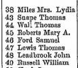
Have narrowed it down in 1868 directory to between Sandy Lane and Park street (later Bordesley Park Road). The section on the census only includes the south side of the Coventry Road. Numbering was continuous so 46 was between 45 and 47,
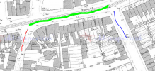
On this 1889 map the green line is Coventry Road, the red is Sandy Lane and the blue is Bordesley Park Road. By 1890 the numbering had changed and odd numbers were on the south.
1621079217739.png
 
Just thought if Tinpot looked at the 1861 census to see if the Clement's Arms is listed near number 46, hopefully between 28 & 32 if not actually numbered itself.

If it isn't look for another pub to give a general location and go from there.
 
Clement's Arms is on the north side of the Coventry Road isn't it? So not on same section of census. I used the census and it is south side of Coventry Road from Sandy Lane to Hay Mills Road (I think).
 
Last edited:
A number change before the 1951 map then. My first thought on location was more luck than judgement.
These houses would still be there when I was younger. Just going up The Kingston Hill with a group of maisonettes on the opposite side. I didn't spot that there was a Harriet Dobbins living there the first time I looked at this census. Mary Ann's family were Dobbins.
 

Attachments

  • IMG_1816.jpg
    IMG_1816.jpg
    170.7 KB · Views: 4
Last edited:
Without a suitable old map of Birmingham, this is only guesswork Tinpot but I believe that 46 Coventry road which technically runs from Birmingham to Coventry would have been in Small Heath near Digbeth near the numbering start of the road. Even as a child, the house numbers already ran into the 1000s not far beyond Yardley. Forty six might have come under the auspices of Aston as it was the registration district for births, deaths and marriages for some people living in Small Heath in at least Edwardian times even though it was not Aston per se. The road layout in that area has been changed beyond recognition I suspect. Green lane Small Heath would have been very close by. Let's hope that someone has an old OS map.
 
Back
Top