-
Welcome to this forum . We are a worldwide group with a common interest in Birmingham and its history. While here, please follow a few simple rules. We ask that you respect other members, thank those who have helped you and please keep your contributions on-topic with the thread.
We do hope you enjoy your visit. BHF Admin Team -
HI folks the server that hosts the site completely died including the Hdd's and backups.
Luckily i create an offsite backup once a week! this has now been restored so we have lost a few days posts.
im still fixing things at the moment so bear with me and im still working on all images 90% are fine the others im working on now
we are now using a backup solution
You are using an out of date browser. It may not display this or other websites correctly.
You should upgrade or use an alternative browser.
You should upgrade or use an alternative browser.
Curly
master brummie
Can anyone tell me if Canal Street was in the St. Phillip's area in Birmingham in 1816, please?
Take a look at post #15 of the following thread https://birminghamhistory.co.uk/forum/index.php?threads/canal-street-aston.8306/ I don't think this could be considered the St Phillips area of Brum.
If you have been prompted by a photograph with a long line of handrails, then that is Canal St. in Wolverhampton.
AnnieB
master brummie
Thank you for this info but it is to do with a baptism of a 3 x great aunt who was baptised in St Phillip's, Birmingham on 25 November 1816. The record states that she was born on 1 November 1816 and lived in Canal Street and I wondered where Canal Street would have been located.Take a look at post #15 of the following thread https://birminghamhistory.co.uk/forum/index.php?threads/canal-street-aston.8306/ I don't think this could be considered the St Phillips area of Brum.
If you have been prompted by a photograph with a long line of handrails, then that is Canal St. in Wolverhampton.
Curly
master brummie
OK, please start here as Brum is today. link: https://goo.gl/maps/bY1i9NeonbEMAbYb8. Canal St. was in the 'block' at the top of which was Bagot St. and at the bottom Lawson St.. To either side would be Lancaster St & Staniforth St. You can then expand (shrink) the map and you'll find St. Phillips approx 1500m to the SE. Some discussion would suggest that Canal St, *was* somewhere near New Canal St, (Digbeth Area) and therefore not close to St Philips.
A further map is at https://www.british-history.ac.uk/os-1-to-2500/birmingham/014/01 and a close up of the relevant area is:-
So the answer to your question is yes, sorry to have mislead.
My excuse - it was late Sunday 11.19 when I tried to answer this .
.
A further map is at https://www.british-history.ac.uk/os-1-to-2500/birmingham/014/01 and a close up of the relevant area is:-
So the answer to your question is yes, sorry to have mislead.
My excuse - it was late Sunday 11.19 when I tried to answer this
.
Last edited:
AnnieB
master brummie
Hey, no problem! Thank you so much for your time.OK, please start here as Brum is today. Canal St. was in the 'block' at the top of which was Bagot St. and at the bottom Lawson St.. To either side would be Lancaster St & Staniforth St. link: https://goo.gl/maps/bY1i9NeonbEMAbYb8. You can then expand (shrink) the map and you'll find St. Phillips approx 1500m to the SE. Some discussion would suggest that Canal St, *was* somewhere near New Canal St, (Digbeth Area) and therefore not close to St Philips.
A further map is at https://www.british-history.ac.uk/os-1-to-2500/birmingham/014/01 and a close up of the relevant area is:-View attachment 151672View attachment 151672So the answer to your question is yes, sorry to have mislead. My excuse - it was late Sunday 11.19 when I tried to answer this earlier.

Heartland
master brummie
The Day Boat was a term applied to craft where those that worked the craft lived on land and worked the craft for local trips. These included movement of coal from pit to factory, bricks and rubbish. They may be completely open or provided with a basic cabin for shelter.
It was the single cylinder Bolinder engine I remember on the canal boats. You can imagine the size of the piston as a 6-litre engine that you took your life in your own hands to start one up.
First it was the blowlamp the head to warm things up. Then a spring-loaded pin on the flywheel that would propel you backwards out through the door if it fired too early.
They had a very distinct dub, dub dub sound that would know the soot off the tunnel roof down as you passed through
First it was the blowlamp the head to warm things up. Then a spring-loaded pin on the flywheel that would propel you backwards out through the door if it fired too early.
They had a very distinct dub, dub dub sound that would know the soot off the tunnel roof down as you passed through
mw0njm.
A Brummie Dude
Bolinder Semi-Diesel Hot Bulb EnginesIt was the single cylinder Bolinder engine I remember on the canal boats. You can imagine the size of the piston as a 6-litre engine that you took your life in your own hands to start one up.
First it was the blowlamp the head to warm things up. Then a spring-loaded pin on the flywheel that would propel you backwards out through the door if it fired too early.
They had a very distinct dub, dub dub sound that would know the soot off the tunnel roof down as you passed through
wow. i remember having to start a boat engine with a shotgun cartridge blank.
mw0njm.
A Brummie Dude
Semi-diesel or Hot Head Engines - Gas Engine Magazine ...Pete, why is it a semi-diesel?
Bob Davis
Bob Davis
PeteBolinder Semi-Diesel Hot Bulb Engines
wow. i remember having to start a boat engine with a shotgun cartridge blank.
You obviously do not own a Marshall Tractor circa 1950
Bob
mw0njm.
A Brummie Dude
what a game
Starting an old Field Marshall with a 12 guage shotgun shell!
i dont but the chap in the village doesPete
You obviously do not own a Marshall Tractor circa 1950
Bob
Starting an old Field Marshall with a 12 guage shotgun shell!
I think this is Perry Barr locks. I took this around the 1970s. Viv.
I must have been standing on the other side of the Lockeeper’s cottage. I’ve marked the metal bar (still there) on the photos. The building just visible on the bank seems to have changed. Looks like it had a roof in the past. And all the shrubs and trees have been cut back to reveal buildings on Walsall Road.

Viv.
Viv.
Last edited:
Bob Davis
Bob Davis
The metal bar is the only means of hand support when walking over the lock gate, they only occur on single gates, on the double gate you just take a deep breath!! Next time you are on the canal look how wide the plank is that you use to cross the canal.I must have been standing on the other side of the Lockeeper’s cottage. I’ve marked the metal bar (still there) on the photos. The building just visible on the bank seems to have changed. Looks like it had a roof in the past. And all the shrubs and trees have been cut back to reveal buildings on Walsall Road.
View attachment 152174
Viv.
Bob
mw0njm.
A Brummie Dude
i was terirfied of lock gates in the dark.The metal bar is the only means of hand support when walking over the lock gate, they only occur on single gates, on the double gate you just take a deep breath!! Next time you are on the canal look how wide the plank is that you use to cross the canal.
Bob
DavidGrain
master brummie
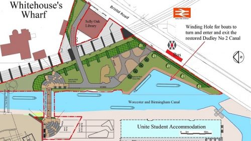
This news about work to start on the Dudley Canal at Selly Oak. Report is taken from TheBusinessDesk.com Regional Business News for the West Midlands
 How the plans stack up
News
June 14 2021
https://www.thebusinessdesk.com/wes...gn=WestMidlands_18th_Jun_2021_Weekly#comments
https://www.thebusinessdesk.com/wes...gn=WestMidlands_18th_Jun_2021_Weekly#comments
The Lapal Canal Trust has signed a £300,000 contract with Land & Water to build the first Selly Oak section of the Dudley No2 Canal.
The new water feature section completes the development of Whitehouse Wharf and forms part of the Selly Oak Shopping Centre owned by M & G Real Estate. The area includes a bridge linking the new shops to Selly Oak town centre, the remains of a lime kiln and a new public square. The large water area is designed to enable boats to turn and enter and exit the soon to be restored Dudley No 2 Canal.
The work has been funded by large donations from Veolia, Garfield Weston, Headley Trust, Landsec, Unite Students, William Cadbury, Jabbs and Rowland Trust. Legal advice was provided by Gowlings WLG.
The Lapal Canal Trust is now focused on raising the further £500,000 required to complete the restoration to Harborne Lane Bridge, which must be completed by 2025.
Andy Street, Mayor of the West Midlands, said: “Congratulations to the Trust on the progress made This is a hugely important project for Selly Oak and the wider region, and I endorse it wholeheartedly. Our canals provide a safe and enjoyable way for residents to exercise, commute and connect with nature. We are all grateful for their restoration work, really encouraging to hear that the contract has been signed and progress is being made.”
Kevin Kirkland, construction director at Land & Water, said: “We are very much looking forward to working with the Lapal Canal Trust and getting started on building the first section of the Dudley No2 Canal and. At Land & Water, we pride ourselves on maintaining and enhancing the UK’s waterways for years to come and this is a perfect example of how the canal can be used to benefit surrounding communities and boat lovers.”
Dudley canal work to begin after £300,000 contract signed
News
June 14 2021
https://www.thebusinessdesk.com/wes...gn=WestMidlands_18th_Jun_2021_Weekly#comments
https://www.thebusinessdesk.com/wes...gn=WestMidlands_18th_Jun_2021_Weekly#comments
The Lapal Canal Trust has signed a £300,000 contract with Land & Water to build the first Selly Oak section of the Dudley No2 Canal.
The new water feature section completes the development of Whitehouse Wharf and forms part of the Selly Oak Shopping Centre owned by M & G Real Estate. The area includes a bridge linking the new shops to Selly Oak town centre, the remains of a lime kiln and a new public square. The large water area is designed to enable boats to turn and enter and exit the soon to be restored Dudley No 2 Canal.
The work has been funded by large donations from Veolia, Garfield Weston, Headley Trust, Landsec, Unite Students, William Cadbury, Jabbs and Rowland Trust. Legal advice was provided by Gowlings WLG.
The Lapal Canal Trust is now focused on raising the further £500,000 required to complete the restoration to Harborne Lane Bridge, which must be completed by 2025.
Andy Street, Mayor of the West Midlands, said: “Congratulations to the Trust on the progress made This is a hugely important project for Selly Oak and the wider region, and I endorse it wholeheartedly. Our canals provide a safe and enjoyable way for residents to exercise, commute and connect with nature. We are all grateful for their restoration work, really encouraging to hear that the contract has been signed and progress is being made.”
Kevin Kirkland, construction director at Land & Water, said: “We are very much looking forward to working with the Lapal Canal Trust and getting started on building the first section of the Dudley No2 Canal and. At Land & Water, we pride ourselves on maintaining and enhancing the UK’s waterways for years to come and this is a perfect example of how the canal can be used to benefit surrounding communities and boat lovers.”
Richard Dye
master brummie
Pete, I still am and I think more so now!i was terirfied of lock gates in the dark.


paul stacey
master brummie
great reports Pedro, I actually remember ,walking on that cobbled ramp by snow hill bridge, would have been in the 50's
Heartland
master brummie
Very useful views, but the date the originals were taken make be before publication date.
Picture 1 shows Lock 7 looking to Lock 8 and the Science Museum. It seen that BCN Canal Cottages 46 & 47 were standing then
Picture 2 shows lock 13 and the approach from under Snow Hill Bridge
Picture 3 would seen to be taken from the disused museum building, formerly Elkingtons, prior to demolition to make Cannings Walk. Modern developers have desecrated this area with the creation of Islington Buildings on the side of Fleet Street now. Why they chose Islington as a name needs to be explained.


Pedrocut
Master Barmmie
Bill Dargue tells us that “Broad St was a field track until the end of the 1700s. From around 1780 building began on the high class Islington estate, around what would become Islington Row.” (Islington Row mentioned from at least 1814).
We can see from post 1318 that the extent of the area “Islington” could include Bishopgate Street and the towpath of the canal. There is a reference to a William Mitchell, Steel Pen and Pen-holder manufacturer moving to Washington Works, Cumberland Street, Islington, Birmingham in 1852. This may suggest that the area was loosely defined and extended down towards Gas Street. Maybe to have an address that could be tied to Islington could be considered upmarket.
The upmarket development in Fleet Street is called Islington Gates…
“Leaseholders of Islington Gates have been told to replace the cladding which covers their building. Residents of a Birmingham apartment block feel “trapped” after being slapped with bills for up to £100,000 to replace flammable cladding.”