• Welcome to this forum . We are a worldwide group with a common interest in Birmingham and its history. While here, please follow a few simple rules. We ask that you respect other members, thank those who have helped you and please keep your contributions on-topic with the thread.

    We do hope you enjoy your visit. BHF Admin Team
  • HI folks the server that hosts the site completely died including the Hdd's and backups.
    Luckily i create an offsite backup once a week! this has now been restored so we have lost a few days posts.
    im still fixing things at the moment so bear with me and im still working on all images 90% are fine the others im working on now
    we are now using a backup solution

Back to backs in Ladywood

I found Nelson Street 1937 listed as Summerhill, before I was born but the factory is shown at the back of our house ... really spooky to see it all from the air!
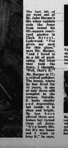
Hi David - glad you found it!! You have to check all photos from surrounding areas - sometimes the squares are in the wrong place - others are from a lower height so you can see far more detail. I recommend a large beer (or 3) and plenty of patience - there are some absolute belters on this site but you have to find them!
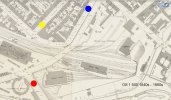
If you fancy a wonder, try Lucas Gt King St, Tyburn Rd, M&B Brewery Cape Hill, Hockey Station / goods yard and New St Station area - all have some stunning photos. Its interesting to compare views from pre and post war - you can then see where the bombs hit. Further afield, Walsall Town Centre, Stratford on Avon and tracing the "bumble hole" line across the Black Country are good too.
 
If you fancy a wonder, try Lucas Gt King St,
Coincidentally, my Gt Aunt Mirry worked in munitions at Joseph Lucas where she received a clock after 25 years of service. I don't know the name of the road but it was in Sparkhill. I attach a photo circa 1945-50 around about the time she worked there plus photos of her retirement presentation gifts
 

Attachments

  • Joseph Lucas 1945-50.jpg
    Joseph Lucas 1945-50.jpg
    1.2 MB · Views: 13
  • Mirriam Evans Joseph Lucas 1.jpg
    Mirriam Evans Joseph Lucas 1.jpg
    1.2 MB · Views: 11
  • Mirriam Evans Joseph Lucas 2.jpg
    Mirriam Evans Joseph Lucas 2.jpg
    1.1 MB · Views: 10
  • Mirriam Evans Joseph Lucas 3.jpg
    Mirriam Evans Joseph Lucas 3.jpg
    1.3 MB · Views: 11
Last edited:
Hanging in there, before demolition. You have to wonder what happened to te older residents.
 

Attachments

  • Screenshot_20240129_145609_Chrome.jpg
    Screenshot_20240129_145609_Chrome.jpg
    378.6 KB · Views: 33
  • Screenshot_20240129_145543_Chrome.jpg
    Screenshot_20240129_145543_Chrome.jpg
    254.3 KB · Views: 32
  • Screenshot_20240129_144057_Chrome.jpg
    Screenshot_20240129_144057_Chrome.jpg
    480.5 KB · Views: 32
Good scanned newspaper clippings, it is a pity they aren't higher resolution because it is difficult to read the text.

Edited to add that from what I can make out in the photo with all the cats, the cats are all strays that belonged to people that had left the area; I have a copy of that photo but previously thought all the cats belonged to the lady in the photo, this throws a completely different light on the photo. I recall that my mother had our cat 'Blackie' put down because she said it wouldn't settle in our new house and would just try to find it's way back to Ladywood. I was really upset about it at the time and since appreciate that it isn't true. Interestingly, our village was partially flooded during Storm Frank and the residents of flooded houses had to vacate their houses for up to a year or more while they were refurbished. During that period we had lots of stray cats visiting our house which is on a hill and was not flooded. I think we fed five strays during that time and eventually they all disappeared, two died.

From what I recall, younger families moved away first and houses were not re-rented but boarded up. In my case my Grandfather died there and my Gran went to live her daughter. We tried to convince my great Aunt to come and live with us in our new house at Great Barr but she refused and just wanted to stay where she was born as did many of the older folk and she eventually died in her house which was boarded up and not re-let.

What was once a thriving community where everyone knew each other turned into a neighbourhood of creeping isolation and deprivation for the older folk that remained amongst boarded up and demolished houses. When a block was empty it was demolished and the environment became equivalent to an apocalyptic disaster. It was just a matter of time waiting for the older 'remainers' to die and my father said most died prematurely from 'broken hearts' at the destruction of their community.

The families had come through the trauma of two world wars and were eventually defeated by their own government because they lived in houses without an indoor kitchen, bath and toilet. I recall my Father saying that ironically, the Council now wanted to do something Hitler's bombers had failed to do and that it is a funny life, all just a big giggle to enjoy when and where you can because you never know what is waiting for you at the dawn of a new day.
 
Last edited:
Good scanned newspaper clippings, it is a pity they aren't higher resolution because it is difficult to read the text.

From what I recall, younger families moved away first and houses were not re-rented but boarded up. In my case my Grandfather died there and my Gran went to live her daughter. We tried to convince my great Aunt to come and live with us in our new house at Great Barr but she refused and just wanted to stay where she was born as did many of the older folk and she eventually died in her house which was boarded up and not re-let.

What was once a thriving community where everyone knew each other turned into a neighbourhood of creeping isolation and deprivation for the older folk that remained amongst boarded up and demolished houses. When a block was empty it was demolished and the environment became equivalent to an apocalyptic disaster. It was just a matter of time waiting for the older 'remainers' to die and my father said most died prematurely from 'broken hearts' at the destruction of their community.

The families had come through the trauma of two world wars and were eventually defeated by their own government because they lived in houses without an indoor kitchen, bath and toilet. I recall my Father saying that ironically, the Council now wanted to do something Hitler's bombers had failed to do and that it is a funny life, all just a big giggle to enjoy when and where you can because you never know what is waiting for you at the dawn of a new day.
david after you clicked on the images did you then click on the little spy glass top right...should then enlarge

lyn
 
Yes Lyn but the text is blurred, I even copied and pasted into my graphics program and enlarged further but it is still blurred
 
Yes Lyn but the text is blurred, I even copied and pasted into my graphics program and enlarged further but it is still blurred
ok david...maybe viv could repost them a bit larger i agree the txt is a bit on the small side

lyn
 
Is this text any better ? Still not great, but I originally only scanned the whole page, I usually scan in sections.
 

Attachments

  • Screenshot_20240215_154920_Gallery.jpg
    Screenshot_20240215_154920_Gallery.jpg
    82.7 KB · Views: 9
  • Screenshot_20240215_154926_Gallery.jpg
    Screenshot_20240215_154926_Gallery.jpg
    60.4 KB · Views: 9
  • Screenshot_20240215_154915_Gallery.jpg
    Screenshot_20240215_154915_Gallery.jpg
    69.3 KB · Views: 9
  • Screenshot_20240215_155604_Gallery.jpg
    Screenshot_20240215_155604_Gallery.jpg
    80.2 KB · Views: 8
Where would Sheepcote Street have been in 1840 please? I know Mill street fed onto Nelson Street in 1837 (One of my way backs was born there) but her brother was born in 1840 at Sheepcote Street. It looks as it Mill street later became part Grosvenor Street West, which led onto Nelson Street in 1837 but in later maps (1885 and 1933) this now looks like Sheepcote Street. Hence my confusion

I'm just trying to get my bearings. If anyone can confirm this would be great.
I attach a map 1840-1890 showing Sheepcote Street marked with a red dot, Nelson Street yellow and Sheepcote Lane blue. I don't recall a Mill Street but here is a link to the map I am referring to if it is of any help.
 

Attachments

  • Map Sheepcote Street 1840-1890 b.jpg
    Map Sheepcote Street 1840-1890 b.jpg
    178.8 KB · Views: 6
I think you answered your own question. As Birmingham expanded a lot of streets were renamed. In 1830s there were 2 streets that became Sheepcote St - Crown St and Nelson St. To add to the confusion there is also a Sheepcote Lane and by the 1880s there is a Nelson St West running parallel to Sheepcote Lane...

0 - Crown and Nelson St.jpg 0 - Sheepcote St.jpg 0 - Nelson St West.jpg
 
I think you answered your own question. As Birmingham expanded a lot of streets were renamed. In 1830s there were 2 streets that became Sheepcote St - Crown St and Nelson St. To add to the confusion there is also a Sheepcote Lane and by the 1880s there is a Nelson St West running parallel to Sheepcote Lane...

View attachment 190597 View attachment 190598 View attachment 190599
Looks that way. On this journey I also found where Fordrough Shreet (and Wharf Street) which later disappeared. Very Useful foray into maps. Very useful source is the following which has a 1837 ish map which seems to predate some of the back to back builds to the south. No idea of the date, but I can date it to at least 1837 as thats when an ancestor of mine was born in Mill Street. Bread street is on there which was around in 1863 as another relative died there, and so was Fordrough street where my Gt Gt Gt grandfather died is also there which is long gone but fed directly into Severn Street. Very useful map indeed.

 
Back
Top