hi mike...cant see a map on post 4Lyn
There is a 1950s map already atm post 4
lyn
hi mike...cant see a map on post 4Lyn
There is a 1950s map already atm post 4


hi col..you have been busy...just going to study your latest findings and hope some of our other members can join in ...Hi Lyn, thanks for your interest. Since I posted I have found some more info. My initial thoughts on the pork butcher idea have been blown out the water as I followed a wrong lead. On checking an old map of 1888 the shape of the bank is very different. I had assumed that it was always a bank but it is clear that back then it was a yard with an high retaining wall alongside the railway line and a gate, off Monument Rd next to the end building which was a cafe/dining room no 71, shown as a fence behind the bill posters wooden ladder support frame in the right corner. The bridge spanned the railway and canal and the next building on the far side is the Bridge Inn no 73 so I believe the yard was probably no 72. I know that the area was unstable and I think the yard may have only lasted around 30-40 yrs before being reduced to a bank and the wall demolished. Further remedial work took place in 1957/58 when an house alongside the bank was demolished and a new corner wall built along with a huge concrete supporting block. So the question is what business was no 72? I think it could have been to do with horses, blacksmith, Hansom cab storage yard/stable. My 1879 Post Office Directory has no mention and shows the buildings were still to be built/completed, my 1908 Kelly's has no mention of no 72 or any other edition afterwards. I have a 1923 aerial photo that shows the bank in place and a Godfrey map of 1918 still showing the original so the development must have taken place between these dates. But really I'm trying to find any mention of no 72 between the gap of 1879 and 1908. Sorry to have gone on but I wanted to give as much detail as possible. Hope someone out there can come up with the goods.
Thanks,
Colin
View attachment 182317View attachment 182318View attachment 182319
Hi Lyn, from the beginning around 1880 up to whenever the yard disappeared and was reduced to a bank which I guess to be around 1920 ish as my 1918 map shows it still a yard but my 1923 photo shows it as a bank.colin i know you are trying to find out what business was at no 72 ..what years are you looking for
lyn
Hi Mike. where did you get the OS map of Ladywood from in post 37? I have found a few online but not as good detail. In particular I am looking for Nelson StreetWelcome to the forum. I assume that the full address is 1 back 101 Ladywood Road (the Road possibly being just a squiggle. Below are two maps from c1950 (it was still there then) and c1889 showing its position.
I have moved this to the streets and neighborhoods section
View attachment 153986View attachment 153987
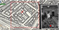
Hello Linda, would you be willing to share a section of your map covering Nelson Street, the area I am interested in is enclosed in red on the attached map which does not have the same detail as your map and it is also incorrect as to where buildings and structures are? I have a lot of old photos of my house and my intention is to reference the map with the photos and indicate the angle at which the photos were taken. I know I am a sad person with nothing better to do on dark nightsI have attached a 1955 map of Ridley street, 7 back of 10 (10 is on Ridley Street) No 7 behind.
")

Brummie bri I was born in Dudley Road Hospital but I spent my early day's in a draw , not far from you do you remember where the doctor's were situated at the traffic lights corner of Monument Road and Summerhill Row we used to live in the houses before the doctors and then moved to Springfield StHi all
I was born and lived the first five years of my life in St Marks Street, Ladywood. My Nan lived in Alexander Street. Even now, 50 years later I can clearly remember the layout of the back to back houses, the yards, the alleys and the streets, but has anyone got pictures of the area from those days (1955 to around 1961). I can remember mom, 'aunty' rose and 'aunty' hilda doing the washing in the scrub house at the end of the yard on a monday morning, with the dolly, the blue cubes and the large wringer. I remember the toilets in the yard (you learnt to whistle from an early age) and the newspaper ripped into squares hanging on the back of the toilet door. As a kid dad would lift me up to see over the bridge and watch the steam trains come down the track, and standing outside the pub with a vimto (and straw) whilst the menfolk were in the pub (cant remember the name of the 'local' sadly). We played at the 'rec' which was a concrete area with a fence round it, though when the big kids come round they would chase us off and we'd be back in the street. Ah, happy days.
i remember when the slums were coming down, auntie rose and auntie hilda moved into the new tower block (Canterbury Tower) but we moved to Northfield and looked out on green fields from our flat - it was like moving to a new country for us !
But i digress. What i'd like is pictures of the area, specifically from around the 50's and early 60's although any from the area when it was still back to backs would be great. can anyone help ?
Wow! Now that's more like how I remember the layout, we lived at 4/91 and as you say the entry to the square can just be seen about 1/2" left of the purple arrow next to 91. I do recall a factory at the back of our houses which I now see as a Printers Works but I think it may have been derelict with smashed windows. I can also see my best friend's houses at the back of 77, it's like going back in time. The house north west of your red arrow was known as "the big house", the huge garden was left wild, I would climb over the wall along the path to our house to get into that garden and walk down to my Great Grandfather's house at 97 Nelson Street, just off the map. It is like a rabbit warren with no logical design and seems to be piecemeal. Imagine building an engineering works and attaching houses to it! Could I impose on you further by requesting the section of the map further south up to Barker Street, which would show Great Grandfather's house at 97? The map detail looks like 1:1250 OS, does it have a reference number?I think you're highlighting a house at the back of Garbett St. This is the 1950 map with 91 at the very bottom (purple arrow), pink arrow points to 4 back 91. The entrance to the backs is between 91 and 93, and no. 2 is labelled as 2 back 93, the other 5 back of 91. And I'd say that the house to the left of your second photo was 6 back 101...
View attachment 186380
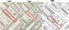
I assume you don't have the section of map south of the one you posted which is a pity. However, a bit more research has been interesting, having discovered maps for 1887 and 1914. It would appear that in 1887 my house was indeed back to back with 8 smaller houses to the NW in what was named Cambridge Close. In 1914 those houses and gardens were shown as being demolished along with outhouses and 4 back to back houses fronting on to Nelson Street providing a cleared site. In the 1950 map a Printers Engineering Works has been erected on the cleared site although my recollections are that it was derelict in the early 50's. It beggars belief that houses were demolished to provide a site for a factory which utilised the fabric of existing house walls in it's construction.I think you're highlighting a house at the back of Garbett St. This is the 1950 map with 91 at the very bottom (purple arrow), pink arrow points to 4 back 91. The entrance to the backs is between 91 and 93, and no. 2 is labelled as 2 back 93, the other 5 back of 91. And I'd say that the house to the left of your second photo was 6 back 101...
View attachment 186380
Wonderful, many thanks. It is remarkable how the map triggers certain memories. By the corner of Barker Street was a lamp post we used to climb on and that Tool Works used to press metal disks from sheets of metal, lots of which got scattered on the street and pavement and we collected them often swapping them for cigarette cards and other items. My Aunt Bess had a shop somewhere between 100 and 110, maybe 102. Here is a photo taken from my house looking SW towards b2b's on Trafalgar Place which were accessed through the entry between 99 & 100.
My Aunt Bess had a shop somewhere between 100 and 110, maybe 102. Here is a photo taken from my house looking SW towards b2b's on Trafalgar Place which were accessed through the entry between 99 & 100.
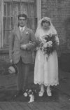
Thanks, you are correct, Ralph was Grandfather's brother they served together in 7th Queens Own Hussars fighting the Turks in Mesop, his other brother Fred was MIA 14/7/16 Memetz Wood, Somme. Ralph and Bess had 3 children, Ron and Billy, both now deceased and Alice who I used to be in touch with because she did lots of research on family history. Here is a wedding photo of Ralph and Bess, which I think may have been taken at the back of Great Grandfather's house 97 Nelson Street.If your aunt was the wife of Ralph (your grandfather's brother?), then they are listed at no. 100 on the 1939 register and ERs


Remarkable photos, I will take a look to see if I can find any of Nelson Street. The houses are certainly at a high density per acre but when they demolished them all and replaced them with high rise tower blocks they probably achieved the same density but ripped out the social heart of the community, you might get to know some neighbours on your floor or a chance meeting with someone in the lift. Some modern housing estates are approaching such densities, the norm used to be 10/acre but now 20/acre, cars won't fit into the small garages and hardly room to swing the proverbial moggie between them.If you explore the aerial photos collection on Historic England at
you can have hours of fun zooming in on countless photos of......well just about anywhere in the UK!Aerial Photo Explorer – Over 400,000 aerial photos in Historic England's digitised collections | Historic England
Explore England's changing landscapes through historic aerial photography, showcasing the growth and transformations of urban and rural areas.historicengland.org.uk
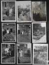
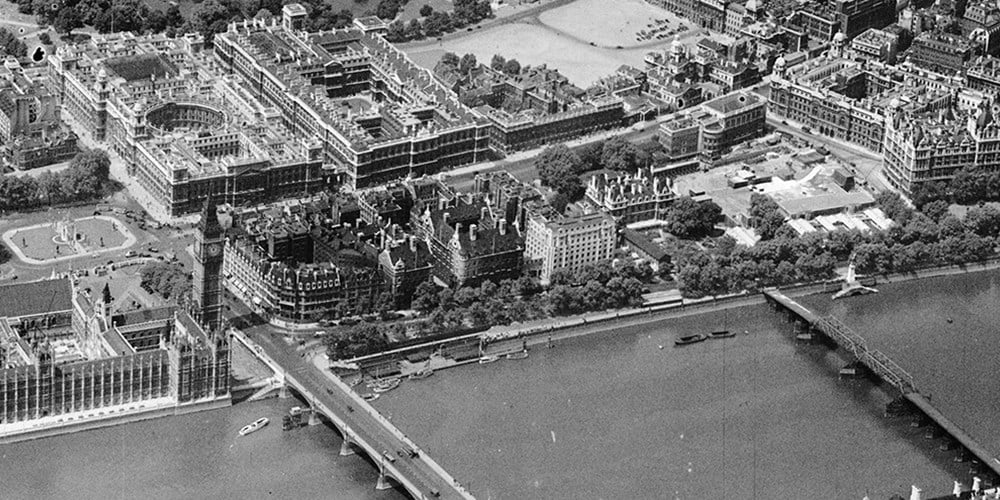
Here are some Ladywood-area back to backs (not far from Five Ways) in 1935:-
View attachment 186522
View attachment 186523
View attachment 186525
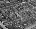
This is one of the photos of Five Ways area they came from - boy did they pack 'em in in those days!!!
View attachment 186524
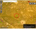
You should see something like this - this is the Ladywood area:-Unless I have overlooked something, there don't appear to be any aerial photos of Nelson Street circa 1940-50. Here is the image I am presented with, I assume the aerial images available are indicated by the red, purple or green layer icons but there aren't any in the area I am interested in shown by the red circle. Or am I searching incorrectly?


Actually you have the squares / dots - you have just zoomed in a bit too far! Check all photos from surrounding areas (the one I posted above were from Five Ways looking westwards). As well as the highlighted photos if you click an orange area (if it has one - not all do) you will get RAF or USAAF aerial photos.Unless I have overlooked something, there don't appear to be any aerial photos of Nelson Street circa 1940-50. Here is the image I am presented with, I assume the aerial images available are indicated by the red, purple or green layer icons but there aren't any in the area I am interested in shown by the red circle. Or am I searching incorrectly?