-
Welcome to this forum . We are a worldwide group with a common interest in Birmingham and its history. While here, please follow a few simple rules. We ask that you respect other members, thank those who have helped you and please keep your contributions on-topic with the thread.
We do hope you enjoy your visit. BHF Admin Team
You are using an out of date browser. It may not display this or other websites correctly.
You should upgrade or use an alternative browser.
You should upgrade or use an alternative browser.
What Happened To The Lake House In Boldmere
- Thread starter Cardean17
- Start date
Lady Penelope
master brummie
Found a reference to "Boldmere Lake Cottage"- maybe it was connected with the Lake House. Viv.
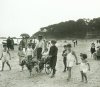
Viv, this is not so much going off at a tangent rather 'an aside' - your post mentions a goat, harness and carriage. I was given a book entitled '100 years at the Seaside' yesterday compiled by Ammonite Press which shows a goat on the beach (and you don't see too many of those do you?) It has a harness and carriage and passenger. Photo taken in 1913. Coincidentally it was taken at Seaview on the Isle of Wight where we are going in two weeks time.
Attachments
Lady Penelope
master brummie
Hi Lyn, As far as I know the house was definitely called The Lake House although the road is Lakehouse Road. I will check all the censuses but as you know they can be a bit misleding. It's still a bit of a mystery as to when it was actually built but sometime in the early 1800's and probably extended through the years. We've narrowed the demolition down to the 1930's so far.
Lady Penelope
master brummie
My post #138 shows the site of the lake after being drained (not sure how but definitely by human intervention) and this was drawn c1857. The presence of the residue of the lake was confirmed by the nice occupants of one of the 3 houses to the right of Lakehouse who told me that the lake was 'at the back'.
The fate of the lake is also explained in this excerpt from an address given by William Fowler Esq JP, President, to the members of the Erdington Institute on April 27th 1885, entitled ‘A History of Erdington'.
A little to the south of the Chester Road, not far from Oscott College, was formerly situate, what, in my younger days was was always spoken of as Baldmoor or as commonly pronounced, Bolmer Lake.
This is now enclosed and drained and the locality more euphoniously called Boldmere. On the Erdington Enclosure map of 1804 it is shown as a pool of about 7 or 8 acres and is spelt Baldmore; about two thirds of it being in Sutton parish.
“Mere’ is the Saxon word for “lake”, “moor” on the other hand signifies a barren wet marshy tract of land; and “bold” or “bald”, which are synonymous terms, have no other meaning, in the Saxon language as far as I can discover, than that of bold or ‘courageous’ which is evidently inapplicable in this case.
The English word “bald” meaning bare, naked, uncovered, is of Celtic origin and I believe the derivation of the word in question to be Baldmoor not Boldmere.
This is taken from a small booklet found in Sutton library. Mr Fowler notes that his father told him about the lake and judging by the date of the address and working backwards, the lake must still have been there in Mr Fowler Snr's time.

Lady Penelope
master brummie
It's very strange Cardean, there are pictures galore of the large houses in Erdington and Sutton but not in our neck of the woods. We've always been in No Man's Land here. I'm still looking for a photo of Broadfields House which stood at the Yenton. There were also some very large houses down Chester Road from The Lake House but no pictures have surfaced so far. We can only hope!
Lady Penelope
master brummie
Post deleted - wrong information!
Last edited:
berniesims
proper brummie kid
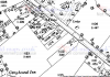
Hi. My name is Sims and my GGG aunt “Kaziah Yates” lived at the Laurels in 1861I traced the Chester Road, the Greyhound and the two strange blobs at the bottom of what I think are plots 228 & 231 (they are at the bottom of the plot adjoining the Lake House plot and sit on the boundary). I then printed Janice's map from post #91 and allowing for the slightly different scale they coincide brilliantly. So I think that the 'blobs' which I originally attributed to marks on the map are actually the last residue of the lake. This would make sense as the occupant of one of the houses told me that the lake 'was at the back'. You can just see a small amount of marsh on the corner of the plot adjoining Chester Road.
I also think that the strange thing on plot ?224, at the bottom of the road from the church is a drain and either a stream or culvert. It appears to end abruptly when it hits the boundary although I think it carries on. There was no communication between Erdington and Sutton and certainly no love lost. The plots were sold off and houses appear on later maps. The land would have to be drained.
So all that remains is for me to type all this up with everyone's findings which may take me a while as there are a couple of things to sort out. Basically though, yes, there was a lake. I believe it was a glacial 'tear drop lake' and would have become much deeper in the wetter months. So thank you to all the geologists, historians, geographers, detectives and other interested parties! You all helped to prove that it was a natural lake that disappeared through man's intervention. I think the mystery has been solved.
on Chester Road. Try as I might I cannot find a map that shows this house. Any info would be greatly received
Last edited:
Pedrocut
Master Barmmie
I think it is on the maps but is not named.
On this 1884 map - The Greyhound is marked and also the "lodge" - both appear on the 1861 census record. This means one of the houses shown should be The Firs.
The map led me to check the last mention I could find for The Laurels and found the owner to be FW Massey in 1912. He appears on the 1911 census, and this is the way the Censor goes...(Map 1887)

berniesims
proper brummie kid
You guys are amazing, thanks for your help. John Yates was a manufacturer in Birmingham and quite wealthy as I have discovered. Would be great if I can find the location of his home (The Laurels)

Bob Davis
Bob Davis
The great pity with this one is that none of the censuses (or is it cencii) give any house numbers, they seem to run from New Oscott to Gravelly Lane and apart from the 1891 census no house names are mentioned. Interestingley the age difference between Mr & Mrs and the staff they employed so it must have been a fairly big house. By the way where was the General Cemetery mentioned in the newspaper cutting in post 172?
Bob
Bob
Lady Penelope
master brummie
Hi berniesims, I spent a lot of time looking at the Yates family connection with St Michael's church. I'm not at home for a few days but when I get back I'll search through them for you. As far as I can remember, the Laurels was about where the Baptist church is now on the corner of Boldmere Road. There was also a Yates house at the end of Court Lane.
The enumerator would have zig-zagged over the road as The Laurels was on the opposite side to Gravelly Lane and Chester Villa and Station Cottage, which is still there, is next to the railway.
Bob, the General Cemetery is Key Hill I think. I'm sure I took a photo of his grave so another thing to look for!
berniesims
proper brummie kid
Wow, Pedro where did you find this?
Pedrocut
Master Barmmie
Wow, Pedro where did you find this?
from the Birmingham Daily Post, 18 August 1876 via British Newspapers Online. Now we know the details in his obituary it should be possible to find out more about him. However obituaries seems to help praise!
Lady Penelope
master brummie
I'm pretty sure that these threads have connections to your Yates Bernie. There is a way to do a link but I've forgotten how to do it - sorry - just copy and paste them into your browser.
 birminghamhistory.co.uk
https://birminghamhistory.co.uk/forum/index.php?threads/yates-and-sons.10465/
I feel sure there is a thread about James Yates, the pewterer, on the forum but I can't find it. There are two lots of Yates families who are very similar. However, I do know that an Edwin, lived opposite St Michael's church in Boldmere in a VERY big house!
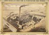
The Sutton Yates were edge tool manufacturers with a huge factory in Aston.
Edwin Yates mayor of Birmingham
Yates street off the Aston Road north,was named after Edwin Yates,in 1865. He became mayor of Birmingham, And after his term in office was over, the street which was formerly was vale street, was renamed in his honour, Edwin was born in 1819 and was part of a very industrial minded family,his...
https://birminghamhistory.co.uk/forum/index.php?threads/yates-and-sons.10465/
I feel sure there is a thread about James Yates, the pewterer, on the forum but I can't find it. There are two lots of Yates families who are very similar. However, I do know that an Edwin, lived opposite St Michael's church in Boldmere in a VERY big house!
The Sutton Yates were edge tool manufacturers with a huge factory in Aston.
Lady Penelope
master brummie
Lady Penelope
master brummie
Aston Road North
I am sure many here - and there does seem to be many with Aston area connections will appreciate them Lyn.
This thread mentions James Yates and also has another picture of a Yates factory.