-
Welcome to this forum . We are a worldwide group with a common interest in Birmingham and its history. While here, please follow a few simple rules. We ask that you respect other members, thank those who have helped you and please keep your contributions on-topic with the thread.
We do hope you enjoy your visit. BHF Admin Team
You are using an out of date browser. It may not display this or other websites correctly.
You should upgrade or use an alternative browser.
You should upgrade or use an alternative browser.
The Moat - Moat Row & Moat Lane
- Thread starter brumgum
- Start date
just going back to the pic on post 48...i asked mike about what looks to most of us like bricks but they are not..here is mikes reply...he also said he had not seen that photo before..
Hi Lyn
Yes, this is part of the old moat. It’s a wall of well-dressed sandstone (not bricks) and it dates to the 13th century- it’s a wall of one of the buildings of the medieval manor house- and it still survives under the Wholesale Markets. The woman and man in the middle of the picture are probably Lorna Watts, the archaeologist who worked on the site and wrote the report, and John Hurst a well-known archaeologist who died a few years ago but who then worked for the Department of the Environment. The photo may well have been taken by Philip Rahtz, another archaeologist who was Lorna Watts’s husband and died a few years ago. Lorna Watts now lives in North Yorkshire
mike
Thanks Lyn (and Mike H). Thought the "bricks" (dressed sandstone) looked too irregular to be modern. It's good to have Mike's opinion on that. But what I am surprised about is the use of bricks to dress the walls at that time. Must be uncommon for the time? Although this could I suppose be the Lord of the Manor displaying his wealth/importance. A moat was not necessarily a defence feature, it could also have been a means of demonstrating importance. A very interesting snippet of history and nice to know it's still there under the markets. Viv.
Absolutely great Lyn. So the moat was probably once much wider at this point or had once taken a slightly different course. Viv.
Absolutely great Lyn. So the moat was probably once much wider at this point or had once taken a slightly different course. Viv.
looks like it viv...these photos must be from a series taken at the time..note the same lady sitting in the same place on both photos which actually i will post together making it easier to compare
Attachments
According to Wikipedia (don't know if this is factual)
The "site was cleared in 1975. During the clearance work, several large sandstone blocks were removed which could have possibly formed the inner wall of the moat. In addition, other stonework was discovered but for reasons of time and money, no detailed excavations took place leading to the production of a floorplan. All recovered rocks were moved to Weoley Castle though nothing has been done to them since".
Viv.
S
Stitcher
Guest
S
Stitcher
Guest
Do you know if it's Jamaica Row Stitcher ? Or do we need identification of the photo ? Viv.
S
Stitcher
Guest
Hello Vivienne, no I don't know for certain but it looks like Jamaica Row that's why I queried it myself.Do you know if it's Jamaica Row Stitcher ? Or do we need identification of the photo ? Viv.
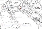
If it was Jamaica row, I would think it would be where the market at the end was, which later was built on as an extension to the Fruit & Veg narket. This is shown as the green area on the map. Jamaica row is marked with a red line. The picture seems to show another road leading off by the buldings in the background, which does not correspond to anything on the map, so I do not think it can be Jamaica row.


Phil
Gone, but not forgotten.
Mike
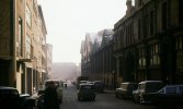
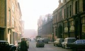
I think we are looking at the corner of Moat Lane and Upper Mill Street this first photo is of the junction behind the group of people. The second photo shows the boundary walls & fence of the market which are also a match to those in the photo. The photo would have been taken just out of view on the right.

![City Smithfield Open Market Moat Row 1901[1].jpg City Smithfield Open Market Moat Row 1901[1].jpg](https://birminghamhistory.co.uk/forum/data/attachments/43/43746-9e3f933b4ea2e3e8b61005a2e02fc300.jpg?hash=nj-TO06i4-)
I think we are looking at the corner of Moat Lane and Upper Mill Street this first photo is of the junction behind the group of people. The second photo shows the boundary walls & fence of the market which are also a match to those in the photo. The photo would have been taken just out of view on the right.

![City Smithfield Open Market Moat Row 1901[1].jpg City Smithfield Open Market Moat Row 1901[1].jpg](https://birminghamhistory.co.uk/forum/data/attachments/43/43746-9e3f933b4ea2e3e8b61005a2e02fc300.jpg?hash=nj-TO06i4-)
If we agree then, I shall move the relevant posts to the Moat Lane (?) thread. Viv.
Thanks from me too Phil. Viv.
MrsBee
New Member
Looks like my great great grandfather had a coffee house on moat row, was next to entry was for "Tarman or Tarmen arms also in mount row. So my family history must be tied there as I was always told my own grandfather had something to do with the big metal ship on building in Digbeth, I think, my family don't really know anything of our history I have pieced together more about their grandparents in the last couple of days than they even knew, but I'm amazed how many errors the computer scans of hand written text causing plenty of problems finding people
Phil
Gone, but not forgotten.
Mrs Bee
You don't say what years you are talking about, but from c1900 there were dining rooms at 15 and 19-21 Moat Row after some years the one at 19-21 disappeared but the one at 15 remained until Moat Row was demolished. In the attached photo number 15 is the cafe on the left taken sometime in the 1960's. The only big ship I remember in Digbeth was the signage for the Royal George public house on the corner of Park Street but I don't know if it was metal or some other material.

You don't say what years you are talking about, but from c1900 there were dining rooms at 15 and 19-21 Moat Row after some years the one at 19-21 disappeared but the one at 15 remained until Moat Row was demolished. In the attached photo number 15 is the cafe on the left taken sometime in the 1960's. The only big ship I remember in Digbeth was the signage for the Royal George public house on the corner of Park Street but I don't know if it was metal or some other material.

Radiorails
master brummie
Some interesting things there Phil, in post #79. There may have been some confusion about the entrances as the Star Cafe had that sign with hand stating that it was the only entrance. The pointing finger and hand was a frequent feature in days past. The railways used them and of course there were (still are some places) finger post giving road directions. The Star proudly advertises their menu, or some of it anyway; it also claims to be a transport cafe and does B&B.
Next door to the Star Cafe seems to be premises of Whitfield, Hodgsons & Brough Ltd. Sounded rather like lawyers but Graces Guide lists them in 1961 as:
Mechanical engineers, specialising in shoe repair machinery. 150 employees
https://www.gracesguide.co.uk/Whitfield,_Hodgsons_and_Brough
This is one of the images from the above link. It is a skiving machine. Apparently skiving machines trimmed not only leather but metals. It is, I am sure, the origin of the more well known meaning of dodging work or school.

Parked outside the Star looks like a Vauxhall Cresta (rust bucket).
Next door to the Star Cafe seems to be premises of Whitfield, Hodgsons & Brough Ltd. Sounded rather like lawyers but Graces Guide lists them in 1961 as:
Mechanical engineers, specialising in shoe repair machinery. 150 employees
https://www.gracesguide.co.uk/Whitfield,_Hodgsons_and_Brough
This is one of the images from the above link. It is a skiving machine. Apparently skiving machines trimmed not only leather but metals. It is, I am sure, the origin of the more well known meaning of dodging work or school.

Parked outside the Star looks like a Vauxhall Cresta (rust bucket).
MrsBee
New Member
It was from the 187Mrs Bee
You don't say what years you are talking about, but from c1900 there were dining rooms at 15 and 19-21 Moat Row after some years the one at 19-21 disappeared but the one at 15 remained until Moat Row was demolished. In the attached photo number 15 is the cafe on the left taken sometime in the 1960's. The only big ship I remember in Digbeth was the signage for the Royal George public house on the corner of Park Street but I don't know if it was metal or some other material.
View attachment 128697
Mrs Bee
You don't say what years you are talking about, but from c1900 there were dining rooms at 15 and 19-21 Moat Row after some years the one at 19-21 disappeared but the one at 15 remained until Moat Row was demolished. In the attached photo number 15 is the cafe on the left taken sometime in the 1960's. The only big ship I remember in Digbeth was the signage for the Royal George public house on the corner of Park Street but I don't know if it was metal or some other material.
MrsBee
New Member
Looks like my great great grandfather had a coffee house on moat row, was next to entry was for "Tarman or Tarmen arms also in mount row. So my family history must be tied there as I was always told my own grandfather had something to do with the big metal ship on building in Digbeth, I think, my family don't really know anything of our history I have pieced together more about their grandparents in the last couple of days than they even knew, but I'm amazed how many errors the computer scans of hand written text causing plenty of problems finding people
Thanks, was off the 1891 census, so well beyond anyone's recollection.Mrs Bee
You don't say what years you are talking about, but from c1900 there were dining rooms at 15 and 19-21 Moat Row after some years the one at 19-21 disappeared but the one at 15 remained until Moat Row was demolished. In the attached photo number 15 is the cafe on the left taken sometime in the 1960's. The only big ship I remember in Digbeth was the signage for the Royal George public house on the corner of Park Street but I don't know if it was metal or some other material.
View attachment 128697
MrsBee
New Member
Phil, I have looked at the pictures of the ship on the George and yes it was that one, so to my knowledge it was made by a company which I know as "Breakers" owned by Ted Breaker who was my grandfather's brother in law, they also built the gates at St Andrews also since removed. I will add this to the relevant threads
Here's a watercolour of the Birmingham Manor House with moat dated 1775. Although there had been a manor house from medieval times, this version of the manor house appears to be Georgian. The spire on the right of the picture is St Martin's.In the 1895 Kellys the William Henry Bourne is at no 21 Moat Lane, next to a beer retailer (which on the c1889 map seems to be The Farriers Arms.). No 21 seems to be the building marked in blue on the c1889 map
View attachment 128717
The manor house was demolished and the moat filled in 1816-17.
(Image from the British Library online collection. Information from the Wikipedia article on the 'Birmingham Manor House'.)
Attachments
brummy-lad
master brummie
Building on the right is Bousfield Bros. in Kelly's 1904 it is listed as Smithfield vegetable market & Dean Street, I don't know that area but assume this is the area of Moat Lane. I only found this listing because I couldn't read the whole name just 'ousfield' a google search brought up an eBay listing of a Bousfield 'BRASS CHECK TALLY SHILLING TOKEN'.
Attachments
best news ive had for ages  just had this email from mike hodder who used to be bcc archaeologist
The Birmingham Moat has recently been designated a scheduled monument, so it is recognised to be of national importance and is protected by law
click on link below for info...

 historicengland.org.uk
The Birmingham Moat has recently been designated a scheduled monument, so it is recognised to be of national importance and is protected by law
click on link below for info...

The de Birmingham moated site, the seat of the medieval Lords of Birmingham, Non Civil Parish - 1485852 | Historic England
List entry 1485852. Grade Not applicable to this List entry. Scheduled Monument: The De Birmingham Moated Site, The Seat Of The Medieval Lords Of Birmingham. May include summary, reasons for designation and history.


