-
Welcome to this forum . We are a worldwide group with a common interest in Birmingham and its history. While here, please follow a few simple rules. We ask that you respect other members, thank those who have helped you and please keep your contributions on-topic with the thread.
We do hope you enjoy your visit. BHF Admin Team
You are using an out of date browser. It may not display this or other websites correctly.
You should upgrade or use an alternative browser.
You should upgrade or use an alternative browser.
Temporary churches, prefabricated churches, tin tabernacles, iron churches, iron chapels
- Thread starter Vivienne14
- Start date
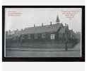
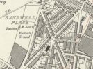
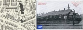
I'm not sure it is the right chapel. 1912 map. Isn't it the "wrong" way on at the corner of the road? comparing photo with map that is.
View attachment 193474
view from victoria road looking down louise road...it definately fits your map jan and clearly a newish build so i think vivs church is still one to solve
could this be a rebuild of vivs church corner of chapel and watt st...think the foot print is the same now called soho community hall..chapel st now redeveloped

Last edited:
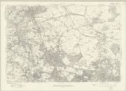
maybe not ..i thought we had a thread for chapel and watt st so grabbed this 1956 map off it...looking at the corner i dont think so but maybe we could do with an older map just to make certain but also noticed on the map there is a church in chapel st already

Can't post it as not on laptop but 1913 map has same footprint.
take it you mean the same foot prints as the 1950s map jan ? in which case its not vivs church
pjmburns
master brummie
Sorry - yes. Same as 1950s and yes don't think that is Viv's church.take it you mean the same foot prints as the 1950s map jan ? in which case its not vivs church
Good thinking. Wait with interest their reply.
ok jan...its worth a try i think
lyn
had this reply from pauletter from handsworth historical society..i did send her the 1950s map and said that the 1913 map had the same foot print so the church cant have been there...fingers crossed paulette or her members can help us solve this one
Hello Linda,
Well this is a new one on me, but I'll circulate it to our members in case anyone can recognise where it is/was, and will also check the 1913 OS map for churches on corners! It's a pity the definition isn't good enough to read the posters and get a possible clue.
Best wishes
Paulette
Hello Linda,
Well this is a new one on me, but I'll circulate it to our members in case anyone can recognise where it is/was, and will also check the 1913 OS map for churches on corners! It's a pity the definition isn't good enough to read the posters and get a possible clue.
Best wishes
Paulette
brummy-lad
master brummie
Link to a detailed map of Handsworth 1912-1913

brummy-lad
master brummie
thanks john but i would say not on that one... think the foot print all wrong... if you look at the photo just a few yards up on the right are facing houses with what looks like large houses next to our church ...just my thoughts at the min...need to research a bit more..not even sure if that is a road or st to the right as it looks very short so maybe a terrace/cul de sac
.jpg")
brummy-lad
master brummie
yes john dont think so..i think the church on your map is still there at the corner of rosehill and villa road


pjmburns
master brummie
Is that the building now called Villa Road Methodist Church. If so I think it was brick built in 1900.This one appears to show a larger house to the right of the church but footprint is not a good match.
EDIT: Appears on both Kelly's of 1908 and 1912 so doubtful if this is the one.
From British History online
Villa Road, Handsworth chapel, seating 552, was opened by the Methodist New Connexion in 1900. Designed by J. G. Dunn of Birmingham in a 'free treatment of 14th-century Gothic' it was built of red brick with light buff terracotta facings, and cost about £5,000.
jan this is just an idea...we both think the church is advertising a concert so if and only if the concert was to be at the church i wonder if there is anything in the newspapers for church concerts in the handsworth area for 1910 or 1909 depending on the age of the advert on the church...just a thought
lyn
lyn


pjmburns
master brummie
I just wondered if it was another corner but, as you say back to the drawing board. Just going to look at newspaper site. Trouble is although the date is 1910 we don't know when the picture was taken.yes sadly wrong jan but i really dont think its a road or street to the right of our church as we can see a house facing us only a few yards down...or if it is its not a very long one...back to the drawing board
lyn