• Welcome to this forum . We are a worldwide group with a common interest in Birmingham and its history. While here, please follow a few simple rules. We ask that you respect other members, thank those who have helped you and please keep your contributions on-topic with the thread.

    We do hope you enjoy your visit. BHF Admin Team

See Birmingham by Post Card

Jules, thats a lovely old picture. I notice all the people walking and of course they have not even heard of 'mugging' because it was not a crime that was commited at that time.
 
The wonderfull picture of Bull Street is so familiar, even though it was years before our time. This was a half way through the first world war at 1916. I wonder if that was the opening to Union Passage behind the lamp post on the left. It used to go through to Bull Street I think and Martineau St. cut it in two.
 
Fantastic picture there, Jules. I woudn't be surpised if it is a lot older - perhaps 1890s? No sign of motor traffic at all.
Peter
 
It is not a picture of a building but it is in Birmingham, apparantly. It is something called or known as 'The Rope Walk' and it somewhere close to Soho Road Railway Station.
 

Attachments

  • Handsworth Soho Rd Rope Walk 1898.JPG
    Handsworth Soho Rd Rope Walk 1898.JPG
    185 KB · Views: 9
Last edited by a moderator:
Fascinating photo, Stiticher. Looking at the map, that must have been where Grasmere Road was built later, just south of Soho Road (as was the station). The station opened in 1889 so the picture couldn't have been much after that.
https://maps.google.co.uk/maps?f=q&source=s_q&hl=en&geocode=&q=%22rope+walk%22+hockley,+birmingham&sll=53.800651,-4.064941&sspn=12.635315,28.300781&ie=UTF8&ll=52.501483,-1.928852&spn=0.003174,0.006909&z=17

The steeple of St Michaels church, St Michaels Road / Soho Avenue, can be seen in the mist above and behind the station name board.
 
Has any one seen the sign RD Haynes ,Rope and Twine Maker, Hockley, Bham.?
Its on the right handside of the picture, just below the level of the railway line.
 
Last edited:
Yes, but a google search produced nothing. Perhaps someone with c 1890-1900 Kellys could look them up?
 
I wondered what 'Rope Walk' referred to and there's the answer. A place where a ropemaker used to stretch out rope.
Close by in Lozells area, I think, there is a Chain Walk also. Amazing how places retain names like that...ages after the reason for them has gone.
 
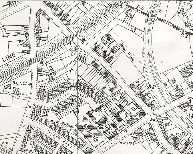
The 1890 map shows the rope walk beautifully (https://www.british-history.ac.uk/mapsheet.aspx?compid=55192&sheetid=10080&ox=0&oy=0&zm=1&czm=10&x=299&y=427 ) The alan godfrey 1903 map available (below) only reaches to just below this point (the map covering the area above is 1913). This shows another rope walk to the east of the railway and slightly to the south, which is not on the 1890 map. Maybe this was a replacement for the one in the picture when it was displaced by building.
mike


Soho_rope_walk_map_c_1903.jpg
 
Richard Haynes, ropemaker 131 Park Road Hockley, which is on the north side slightly to the west of Whitmore Street. But there were 3 Haynes ropemakers listed in the 1895 directory,the other two being H.W.Haynes & co, factory road; Harry Walter Haynes ,105 Soho Road & Factory Road.
Mike
 
A cracking piece of detective work Mikejee. I should know better than to try and mix it with the professionals. Mind you I have learned a lot about Ropemaking and the Chartist Movement. Where ever you get them from please don't run out of pictures.
 
Mike thank you very much for the British History Online map starting point available from your link. I was able to navigate to some of the areas that my family lived in, use the Vista snipping tool, highlight relevant roads & save to my computer, so that is a great facility. It also means that I can compare the developmental changes by comparing with the later Alan Godfrey maps. This is a real educational opportunity that you have presented us with and much appreciated.
 
I got another lump in my throat when I saw the picture of the rope walk in Handsworth. My future parents lived opposite each other in Grasmere Road, in houses built in 1909 or thereabouts. Nanny Walker lived on the railway side of the road and, when I was a nipper, Soho Road Station was still open [I think it closed 1938/39]. The view from her back garden was similar to the view posted, but was taken slightly lower down the hill.
By the time I was born in a nursing home in Villa Road, my parents were married, but quite unprepared. I spent the first 8 months with my parents staying over the road with my mum's parents.
Last summer after my birthday do we stayed on to the Sunday, and had a superb lunch in the Black Eagle round the corner in Factory Road, while my sons' two cars were parked in Grasmere Road. I got to speak to the two families who live in the houses now.
Peter
 
Hi Any one have a card or photo of the HEN & CHICKENS in New Street ? I think it was around No 129 which was my GGG Aunt Letitia Hobdays shop in that Street?
 
Thank you everyone who shows interest and/or explains the history behind these pictures. I got almost all of them from a long since closed shop that used to be in Harborne. The shopkeeper used to save them for me. Some are books, some are odd pages from books and a few are odd pictures. I think they came from house clearances or some such thing. I said before that I did a course as a guide for Brum and that is the reason I purchased them.
Thanks again to you all because I would never have never known some of the things you have discovered /explained.
 
Perhaps I should have posted this on the "Where is this" thread. Its changed that much since 1880 its hardly recognisable.

Phil
 

Attachments

  • City Old Square Georgian Houses.jpg
    City Old Square Georgian Houses.jpg
    70.6 KB · Views: 16
Thank you Stitcher for making these pictures available. As you know I am not a Brummie but consider Birmingham as "my city". I have learned a lot of things about all sorts of subjects since you have been posting the pictures. Thanks again...you are never to old to learn. ..Arkright.
 
Arkright, and everyone else, I am pleased you find interest in the pictures. Many of them are a mystery to me and I find it interesting when some of the more knowledgible members post information relating to certain pics.
 
The Old Square photo is a jem. So that is the old Stork Hotel mentioned in Pye,I think. I presume it is the building on the left.
 
Mike - I see Victoria Road, Handsworth is on the map, my grandparents lived there and I wondered how old the houses were as I had a problem looking them up on the census at that time and before. Mo
 
Stitcher, I loved the photo of Rope Walk in Handsworth, and also Mike thanks for the map.

I lived in Soho Avenue, opposite St Michaels Church, not far from where Soho Station was/is. I was amazed to find out some years ago when researching my family history that my 3 x gt.grandmother lived in Spring Row, Handsworth. I couldn't find this for a long time until I was helped by a lady who was kind enough to send me a map, after we found that it was a row of houses in Summer Road. I'm not sure of the date of the map but my 3 x gt.grandmother lived there in 1861. The Ivy House pub was on the corner, and although the road no longer exists, Ivy Road is where the road was.

The map shows the other side of Soho Road from the station and presumably the Rope Walk would still have been there at the time of this map, just off the map.

Judy
 

Attachments

  • summer rd.JPG
    summer rd.JPG
    321.7 KB · Views: 7
Last edited by a moderator:
Phil, that is a smashing photo of the Old Square. I have never seen that before, and wouldn't have recognised it. Beautiful old houses, and very elegant.

Judy
 
Jayell, I am not that knowledgeable, I post the pictures because I know someone on the forum will have the information to go with them.
 
Mo
Looking at the directories, its not possible to say definitely when the houses were built, as, particularly with houses rather than businesses, they weren't always included. BUT:
The 1890 map shows that at that time the only part of Victoria Road in existence was the short length to the east up to about where louisa road later came, and there were only houses on the north side of the road. Louisa road first appears in the 1908 edition, but there is no indication of extra houses appearing till some time between the 1908 and 1912 editions. Then more seem to have been more built, including some on the south side of the road. So my guess is that louise road was constructed in about 1907, and the road was extended and houses built on the other side shortly afterwards.
Mike
 
Another not very often seen view of Old Square. In this one dated 1891 it is in the midst of being demolished and shows the old BCT Tramway's offices empty awaiting demolition.

See the sign about the site being used for a new Winter Gardens & Exhibition Hall. Anybody have any memory of this, because I had never heard of it.

Phil
 

Attachments

  • City Old Square C of Bham Tramways Co Ltd Office 1891 .jpg
    City Old Square C of Bham Tramways Co Ltd Office 1891 .jpg
    129.4 KB · Views: 18
Excellent picture, Phil!

I'd be inclined to think that the "proposed Winter Gardens" was a bit of wishful thinking. I've certainly never come across a mention of it my 20+ years of Birmingham research.

Maurice
 
In the 1888 kellys, the tramways offices were no 8. In 1886 the buildings comprising that block by the side of upper priory st are unnumbered, b ut are :
Sydney Hass7 ell, chartered accountant
Richard Lunt & co, manchester warehouseman (What's so special about Manchester ??!!)
Achilles Taylor ,printer,(Caxton House)
By 1904 it has expanded (still not numbered) to include several insurance companies and two of the "Inspector of Kings's Taxes".
As you say - funny sort of Winter gardens
Mike
 
I struggled a little, thinking where to post this and I thought this as good a place as any.

Here are a few early drawings of Birmingham, all drawn by Thomas Underwood a printer who ran his business from Castle Street which used to be just off High St.

First we have the old prison which was on Peck Lane a site which is now covered by New St Station.

In front of that stood the Public Offices which housed the magistrate’s courts, the high & low bailiffs & the police.

The last drawing is of 29-32 High St and The Court of Requests, which I suppose can be described as the forerunner of today’s small claims court.

Phil
 

Attachments

  • SE Court Of Requests.jpg
    SE Court Of Requests.jpg
    90.8 KB · Views: 19
  • City Bull Ring Public Offices.jpg
    City Bull Ring Public Offices.jpg
    259.6 KB · Views: 18
  • City Peck Lane Birmingham Prison.jpg
    City Peck Lane Birmingham Prison.jpg
    224.8 KB · Views: 19
Last edited:
March assizes 1904 and The Sherrif carriage just is leaving.
 

Attachments

  • City Corporation St Victoria Law Courts Sheriffs Carriage 1904.JPG
    City Corporation St Victoria Law Courts Sheriffs Carriage 1904.JPG
    193.2 KB · Views: 6
Last edited by a moderator:
There used to be a 'Primrose Day'. I do not know if it was a national thing or if it was peculiar to Birmingham, I also do not know what it's purpose was. This picture shows women with baskets presumably of primroses either selling them or giving them away in exchange for a donation. The picture was taken in Corperation Street in 1904.
 

Attachments

  • City Corporation St 19-04-1901 Primrose Day .jpg
    City Corporation St 19-04-1901 Primrose Day .jpg
    143.7 KB · Views: 9
Last edited by a moderator:
Back
Top