• Welcome to this forum . We are a worldwide group with a common interest in Birmingham and its history. While here, please follow a few simple rules. We ask that you respect other members, thank those who have helped you and please keep your contributions on-topic with the thread.

    We do hope you enjoy your visit. BHF Admin Team

Passages, Alleyways Gulletts and Snickets of Old Brum

Dennis

Heres one I was reminded of the other day whilst searching for something on Temple Row, "Bradford Passage" that ran from Temple Row to Corporation St. I'm guessing that it was older than the nearby North Western Arcade that it ran parallel to. Which the opening of would have made Bradford Passage surplus to requirements. I know that I don't think I ever used it before it was swallowed up by Rackhams new building in the 60's.

Sadly I have no image of this passage itself, but I can manage a map showing it's position, the Corporation St end and the Temple Row end.

Never heard of it. Wonderful addition Phil. Thanks for the research and the postings,
 
When I first researched ny family tree, it soon became obvious that we came from the poor end of Brum. Heck of a lot of both mine, and my originallly Scots wife's rellies, seemed to migrate to Deritend. Milk Street, and Rea Street being quite common...so...this is REA TERRACE. Still extant, but very short and very boring now...but it wasn't always so empty of life...


Rea Terrace.jpgRea Terrace 2.jpgRea Terrace  google.jpgRea Terrace google.jpgRea Terrace now 1.jpeg
 
In that late 18th century, while Revolution raged in France, many in Birmingham feared that religious dissent might lead to revolution against the Church of England and the British monarchy. Dissenters are those that refuse to accept the doctrines of an established church, in this case Protestants who dissented from the Church of England.

Joseph Priestley, a dissenter, was minister of the Old Meeting House in what was then Phillip Street. This lay off Dudwall Lane, later known as Pinfold Street, a site now under New Street Station. The Meeting was burnt down in high-church riots in 1715 and wrecked again in the Priestley Riots of 1791. It was again rebuilt in 1794 with schoolrooms and a library attached. The burial ground was used from 1696, enlarged in 1779, 1869 and 1870; it was closed for burials in 1873 for all but reopened family graves. The building was demolished 1882 for the enlargement of New Street Station and the remains of the dead belonging to both the Old and New Meetings reinterred at Witton Cemetery where an obelisk marks the site. A new chapel in gothic style was built on Bristol Street in 1885. Priestley had written an inflammatory pamphlet that described 'laying gunpowder' under the 'old building of error'. This had caused alarm among supporters of the established church, who believed they were under threat. Priestley had already gained notoriety for his criticism of an attack on the French Revolution by Edmund Burke (a conservative statesman and political thinker).

On 14 July 1791 Priestley and his followers met at a dinner in the Dadleys Hotel, Temple Street, to celebrate the second anniversary of the storming the Bastille. Their opponents took this as an opportunity for full-scale riot. They attacked and burned the Meeting Houses and the homes of a large number of Priestley's friends and supporters, many of them respected Birmingham citizens.


Now the Unitarian Old Meeting House above, built in 1689, was so popular that they had to build an overflow one in DERITEND, of all places. This they called the Lower Meeting House, because of it’s geography. Anyway, to cut a long story short, this was also burned to a crisp by the rioters, and the ruins became a workshop. From the enclosed piece from Catherine Hutton's book, you can see that this area was entered via MEETING HOUSE YARD.

On further investigations, a Bham University Team did an architectural dig in my old rellies stamping grounds of Moores Row and Milk Street in Deritend, AND mentioned Lower Meeting House Yard by name, and look what they discovered?

Ackerman’s Panoramic Map of the area shows the three gabled Lower Meeting House building in glorious detail. A complete new one for me...


Lower Meeting House 1.jpg Lower Meeting House 2.jpg Lower MH Yard  archictural dig text.jpgFig 8  Lower MH  Map.jpgFig 9  Lower MH 1847 Map Marked.jpg
 
Last edited:
A new one on me, off Temple Street - TEMPLE PASSAGE. No idea of it's provenance, but it looks just like a service alley that curves round the shops and restaurants on that side of Temple Street to me...here's a couple of Google shots to show either ends of it.


Temple Passage 1.jpg Temple Passage 2.jpg
 
Last edited:
One en passant from another Thread. BARWICK STREET- A narrow elbow shaped road that links Edmund Street with Livery Street, crossing Church Street. Cut in 1877, and named after William Barwick Cregoe-Colmore, last of the Colmore family. Contains, or is very near to, two Major Hospitals, the gloriously gothic Eye Hospital; and the Ear, Nose and Throat Hospital. Both marked on the map. Both now disguised with new identities. There is a potential photo of Barwick Street, which I include for interest and mischief. Phil and mike may recognise the photo and appreciate it's dissemination to a wider audience perhaps. The Pub on the corner up the Street is unknown, but as Sheffield's was in Barwick street, it has been postulated that this might be the location. But the pub doesn't fit...anyone any ideas?


Barwick St Map.jpg Eye Hospital.jpg Unknown Street 1897.jpg
 
Last edited:
Oh, and I've now reposted everything as was...with only a couple of exceptions...my eyes and fingers will never forgive me...hope you find it was worthwhile...
 
Dennis

Well Done mate, all you have to do now is update all the other threads you posted to, it won't take up much of your time. I think I did my nigh on 3000 uploads in under a month. Mind you though that was 18 hours a day.
 
Thanks Dennis, missed Henn's Walk's fleeting appearance on previous browse of the thread. I'd imagined Henn's Walk to be narrower and shorter. Interesting it's name comes from the Henn family (and NOT as I'd wrongly assumed - connected to the Hen & Chickens).

Brilliant work on this thread Dennis. Viv.
 
Thanks Viv, most appreciated.

Now for something a little more intriguing. MOORES ROW, Deritend. This narrow connection between Milk St and Floodgate St runs at the back of the old Floodgate Street School (now St Michael's Roman Catholic School). Mckenna thought it to be so named "because it is a low-lying spot near the River Rea and would have ben boggy and like a moor". However Carl Chinn dug out a far more interesting and gripping theory from a book he'd found by Roy Palmer “The Folklore of Warwickshire”. Here’s his tale:

“Tom Langley was a policeman who was first stationed in Digbeth in 1927. One night, just after midnight, he was walking down Fazeley Street talking to his sargeant when they heard a terrible and spine chilling scream from the direction of Milk Street. It crescendoed for some seconds and stopped suddenly. Tom thought someone had been called but the old sargeant stood still saying that it was a sound that he would hear again, and although it might be put down to an engine, “some of the old Brums round here say it’s a ghost, but we are paid to ctach thieves not ghosts”. Hearing the sound again two years later, Tom made enquiries. His uncle had served locally and been shaken by the sound but said it was best to forget it. Unable to do so. Tom chatted to a former policeman who was now a night watchman at a factory in nearby Allison Street. His father had also been in the force in the district and he recounted an old story. When Prince Rupert sacked Birmingham in 1643, many of the people of the town had fled to the fields of Edgbaston and Winson Heath. One man named Moore did not. He stayed with his wife and five children in a cottage in Milk Street. Three of Rupert’s men dragged the Moores into the Street and beheaded all of them. The last to be murdered was a girl of thirteen. After seeing the vile deeds she screamed before she was slaughtered. The night watchmean felt that her last terrible cry was still echoing down the years”…..


Fig 8  Lower MH  Map.jpgMoores Row 2 now.jpgMoores Row now.jpgKings Arms  Moores Row Deritend  .jpg


Personally I just liked it because it had what looked to be a great old boozer - The King's Arms - on the corner where the factory is in the first Google shot...and the screaming and shouting may have been Phil coming out 'the worse for strong drink' after a lock-in, the date almost fits...
 
Last edited:
Fascinating story Dennis, well worth the read, so many of these old stories relating to old Birmingham, always so interesting.
paul
 
Cheers Paul, your comments are so encouraging...and apropos of the old Kings Arms shot above, here's another that just includes it on the left edge (to assure it's accuracy of location)....

Moores Row Floodgate street.jpg
 
In the mists of time we had quite a few narrow streets, and many many more interesting Pubs therein. Here's a tale about two Streets and one very famous old pubs.. One of Brum’s most famous Pubs was The Eagle and Ball, or 'The Eagle' as it was better known. There was a large carved figure of an Eagle perched upon a Globe over the door that gave it some extra swagger and class…which ended up in a Solihull man's (a Mr Unite) garden incidentally...no photos survive surely?

The Inn was upon the south side of Colmore Street, and a clue to its exact location is gained from Eliezer Edwards’ OLD TAVERNS OF BIRMINGHAM, from which this tale is largely plundered, who in 1879 said “Its site is now within New Street Station, but the roadway of Great Queen Street passes over what was once the Inn yard, and the present open railings of the Old Meeting House burial ground stand upon the foundations of the wall which originally separated the Inn premises from the chapel yard.“ So although we have no picture or drawing of this place, we can at least have some accurate idea where it was… witness the clips...


Edwards notes that the Inn was not anything pretentious nor memorable in architecture, but it had a large commodious room at the back which became one of Birmingham’s first ever marble alleys. Bit like the Dirty duck in Harborne for them’s that know these things. There are tales of Birmingham’s finest like “George Dixon, and a Mr Kynnersley scrabbling round on their padded knees, playing marbles against Mr Holliday and Oliver Pemberton, whilst Alderman Manton, Mr R.W. Dale, Mr Sampson Lloyd and Alderman Avery, each with a long pipe and beaker of ale, looked critically on…”

In 1789 the House was owned and run by one Joseph Warden, an ancestor of the family known so well in Birmingham at that time, in connection to the iron trade. Mr Warden had a good singing voice, and “his house became celebrated as one where a visitor could not only obtain the sine qua non of those days, a glass of good ale, but might also be certain to hear good singing.” Was it ever thus in the Broadway several hundred years later I pondered happily……
 
Last edited:
Absolutely fascinating Dennis. I love to hear the history of these buildings and streets. Loved the maps as well as I haven't seen them before. Nice to see the position of Shut Lane on the last map as I have a vague connection with that street.

Judy
 
I find the whole of this thread interesting, the stories and pictures attached make the places more real.
Thanks for a great thread Denis, aided and abetted by Phil.
Sue
 
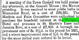
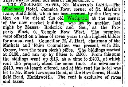
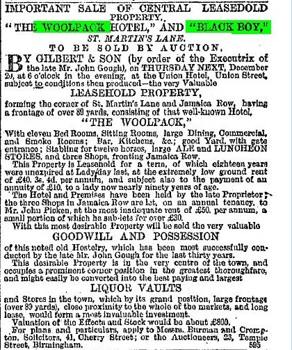
One featured already from the Pubs of the Bull Ring thread....BLACK BOY YARD...what became Jamaica Row, and then the rag market? Black Boy Yard (see Hanson's Map of 1789), and the Georgian three-storied Tavern there used to be called the Black Boy Inn. The term Black Boy refers to the dark skinned complexion of King Charles II. The Inn was painted by local artist A. Tarlington but I cannot find a copy to post. The history of the place is quite interesting, the landlord in 1817 of the Woolpack in nearby Spiceal Street had a dispute with his Landlord, so he bought the Black Boy and took all his customers with him to his new pub, leaving The Woolpack to degenerate and be closed, and sold to a tea dealer. So he then incorporated the name of the Woolpack into his new pub, thus it became the Black Boy and Woolpack. Evidently there was a large carved figure of a negro boy with bright red lips at the entrance of the pub, but this disappeared when the name changes went on...political correctness was not a feature in those days...After a while the Woolpack (which it become known as), was sold for £7,400 to the Town Council and demolished to build the Fruit and Veg market, plus the rebuilding of The St Martins Hotel on the site was completed...

The old prints show a building on the corner of St Martins Lane and I'm hoping maybe they may be of the Black Boy Inn. You never know, it is a three-storey Georgian building....

Black Boy Yard Hanson Map 1789.jpgJamaica Row  St Martins   1938.jpgSt Martins Jennens book.jpgBull Ring Nelson Hotel Stagecoach.jpg
 
A Sale notice for the Black boy in 1877 is given below..The new owner did not have much time there. Approval for the Council buying the Black Boy (or Woolpack) was taken in Feb.1881. At first the St Martins hotel was called the Woolpack, as can be seen below.

Birm_post_16_2_1881.jpg


Birm_post_31_10_1883.jpg


birm__Post_17_12_1877.jpg


Great research mike, confirms some facts nicely...and on the subject of an old Evening Mail shot of a pub that stitcher posted, reputedly called the "Woolpack", and reputedly in "Digbeth", any chance it might have been the one that went to pot in Spiceal Street, which was "High St-in-waiting"?


Woolpack  Digbeth.jpg
 
Don't think we've had this one on yet, although it has been featured many times on this Forum in different contexts. CAMBRIDGE STREET, off The Crescent, running behind Bingley Hall (then) and the Convention Centre now. Cambridge Street emerged as it's own entity in the 1790s, being then more known as an offshoot of the more elegant and famous Crescent. The Crescent having been the first premises of the Women's Hospital and the Theatre etc... I include what Showell's Dictionary has to say, and note his massive plugs for his business. He who pays the piper etc....

Better than all the Theatres and Hospitals though, were two cracking old pubs in Cambridge Street, the Prince of Wales being recently done up and rebranded...not to everybody's tastes it has to be said...and the Cambridge Inn.. (my thanks to Stitcher for the borrowed photos. His are the very best quality on this whole Forum. Truly amazing clarity, I don't know how he does it...)


Cambridge Inn Crescent.jpg Cambridge St  Prince of Wales Pub.jpg Crescent Showells Dictionary.jpg
 
Last edited:
Wow. Simply stunning mike, priceless memories and recordings, many thanks for sharing what must one day surely form part of a Book? You never let us down. That area of the Markets and Bull Ring I find absolutely fascinating, and there are so many more little nooks and crannies still to come...
he said hopefully. Got any more you can share of say, Mark Lane, Lease Lane etc?

Dennis, here's one of Lease Lane looking from Edgbaston Street, up Lease Lane towards the old market. Also in the photo is the Waggon and Horses - or what was left of it - on Edgbaston Street. Viv.

ImageUploadedByTapatalk1349286238.537430.jpg
 
Sorry Paul I should have said it was WW2 bomb damage. But afraid I don't have the exact date. Viv.
 
Viv that picture is a new one to me...and brilliant. May I ask the source please? I thought I had most every book on Brum known to man....cheers. all I have on LEASE LANE, including the first shot of the Grand Turk pub on the corner....the site of the original Leicester Arms, Freeth's Coffee House...so much more on that to come...


View attachment 81719 Lease Lane  Bell Street  1955.jpg Lease Lane  Showell.jpg
 

Attachments

  • Grand Turk  Bell St 1910.jpg
    Grand Turk Bell St 1910.jpg
    639 KB · Views: 59
Last edited:
Hi Dennis. The Lease Lane view is from the B'ham Post & Evening Mail's "Images of Birmingham". Viv.
 
thats a cracking pic post 755 viv..any idea what the building is at the top of the passageway..

lyn
 
Hi Lyn, it's the Market Hall. Think it might be the Worcester Street side, but please correct me if I'm wrong - you know the reliability of my map reading skills! Viv.
 
Just checked a map Lyn and it's not the Worcester Street entrance, but it's looking towards Bell Street. So the top of Lease Lane comes out onto the side of the market!! (True to form, I've a rubbish sense of direction. And to make matters worse I've posted the map upside down. Oh well....). Viv

ImageUploadedByTapatalk1349297626.218202.jpg
 
It's the Fish Market Lyn. If those builders had still been there in post 758, they would have smiled for the camera. Cheers Viv, I've ordered it!
 
Back
Top