-
Welcome to this forum . We are a worldwide group with a common interest in Birmingham and its history. While here, please follow a few simple rules. We ask that you respect other members, thank those who have helped you and please keep your contributions on-topic with the thread.
We do hope you enjoy your visit. BHF Admin Team
You are using an out of date browser. It may not display this or other websites correctly.
You should upgrade or use an alternative browser.
You should upgrade or use an alternative browser.
Passages, Alleyways Gulletts and Snickets of Old Brum
- Thread starter Dennis Williams
- Start date
W
Wendy
Guest
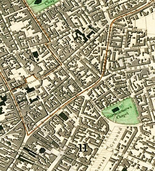
The information is a good help thank you Dennis. The map is great I will save that for my tree. I am sure you are right this would have been the road.Probably not Wendy, the Chappell Street on the map was renamed Bull Street at the time of the Reformation in the 16th Cenrury. More likely your Chapel Street link is the one that bounded the old 18th Century St Bartholomew's Church on the 1888 Map below...
Interestingly, Bull Street took its name from the Old Bull Tavern with its bowling green at the back. Richard Cadbury was at No 92 as a 'linen draper and silk merchant. Richard's son, John, eventually had a tea and coffeee shop next door, but moved to an old favourite of this thread, Crooked Lane to establich a cocoa and chocolate business...the rest is history so to speak...
View attachment 81132
maypolebaz
master brummie
I don't think so mate but thanks for the map, at least I can see I didn't dream the cemetery up !Oh you were THAT side of the road Baz....then you would be thinking of the narrow entrance to the Fire Station Yard perhaps?
View attachment 81156 View attachment 81157
maypolebaz
master brummie
Dennis
if baz stood outside Greys in Bull Street. I don't think he would see much of Upper Priory, unless of course his name is Clark Kent
Well I have been known to leap tall buildings with a single bound, Phil !
There was a short discussion about the passage near Lewis's (Dr Johnson Passage) and the chapel on this thread posts #94 - 96 https://birminghamhistory.co.uk/forum/showthread.php?t=38748&page=7&highlight=bull+street
I've extracted the info and pics of the Meeting House and posted below .......
"This is the Friends Meeting House, Bull Street (Doctor Johnson Passage). Originally it had a small graveyard adjoining the Meeting House and brick vaults. The 1831 Picture of Birmingham description was of "a plain, barn-like edifice but fitted up,in the interior, with peculiar neatness". The original Meeting House was replaced in the 1930s. Viv."
 1855
1855
 Present day - from streetview
 RIBA view originally posted by Richie on "bull street" thread
I've extracted the info and pics of the Meeting House and posted below .......
"This is the Friends Meeting House, Bull Street (Doctor Johnson Passage). Originally it had a small graveyard adjoining the Meeting House and brick vaults. The 1831 Picture of Birmingham description was of "a plain, barn-like edifice but fitted up,in the interior, with peculiar neatness". The original Meeting House was replaced in the 1930s. Viv."
 1855
1855 Present day - from streetview
 RIBA view originally posted by Richie on "bull street" thread
Dennis Williams
Gone but not forgotten
Of course he wouldn't. I never went anywhere near Greys....never seemed to get past Lewis's, and I thought it was in Upper Priory....Doh! Good excuse to post the old Fireman Sam HQ pictures though eh?
Whilst you are here, any chance you or mike could enlighten us about the little passage back of Market Street that ran behind The Vaults (Criterion) pub, and connected Market Street to Jamaica Row at some time? I think it was somewhere near the purple area I've marked. Might be next one down? Anyway, I think I remember mike took some rather interesting shots of Market Street afore they knocked it down, which he might be able to share..? You can just see a Big Pub Lamp on the right of the eerie Market St pic...


Whilst you are here, any chance you or mike could enlighten us about the little passage back of Market Street that ran behind The Vaults (Criterion) pub, and connected Market Street to Jamaica Row at some time? I think it was somewhere near the purple area I've marked. Might be next one down? Anyway, I think I remember mike took some rather interesting shots of Market Street afore they knocked it down, which he might be able to share..? You can just see a Big Pub Lamp on the right of the eerie Market St pic...


Last edited:
Dennis Williams
Gone but not forgotten
"This is the Friends Meeting House, Bull Street (Doctor Johnson Passage). Originally it had a small graveyard adjoining the Meeting House and brick vaults. The 1831 Picture of Birmingham description was of "a plain, barn-like edifice but fitted up,in the interior, with peculiar neatness". The original Meeting House was replaced in the 1930s. Viv."
Great RIBA shot Viv. If you look to the left of the building, you can also see the side of the old Birmingham Women's Hospital Outpatients I think, before we moved to Showell Green Lane. Some stuff below that will go back on the Womens Thread eventually. Promise, but it does show UPPER PRIORY nicely...


Hi all. We have Richie to thank for the RIBA view of the Meeting House which he oiriginally posted on the "bull street" thread. Viv.
Dennis Williams
Gone but not forgotten
Dennis,
Are you enquiring about Smithfield Passage or Smithfield Yard?
Neither really, but feel free...both would be good...
The one I wanted was MARKET STREET. I don't think, on looking back on my first enquiry, that there was an alley that connected Market St and Jamaica Row, just the pub the Vaults...so anything on Market Street itself would also be good..?
Hi all. We have Richie to thank for the RIBA view of the Meeting House which he oiriginally posted on the "bull street" thread. Viv.
Thanks for that Viv. There are a few other photos of Friends House on RIBA but mostly tiny examinations of brickwork etc.
Wish i could have passed on the photos a bit earlier, Viv but time flies and the pictures had only just occurred by chance on that RIBA website I am a Quaker by adoption so the Meeting House is a bit special.
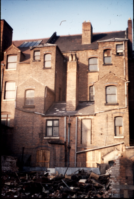
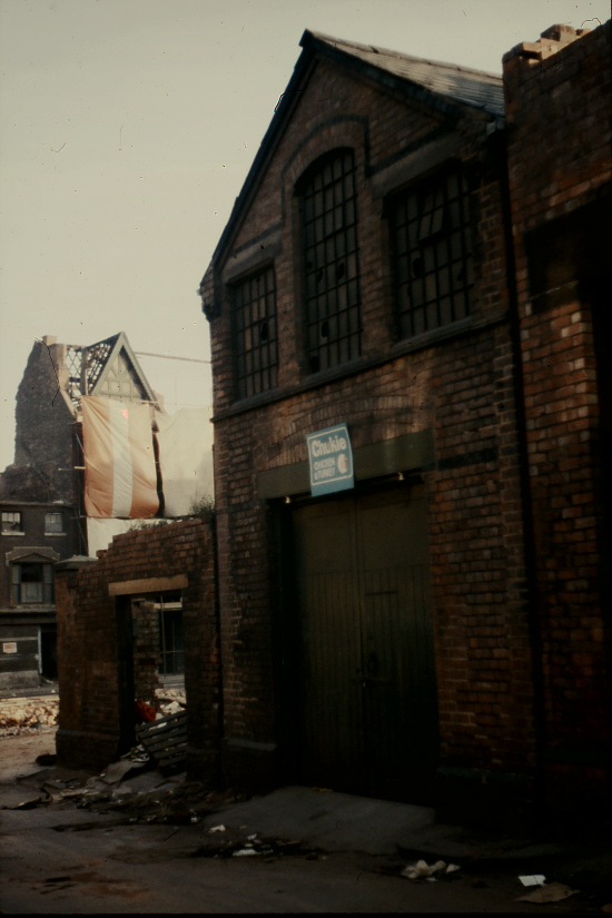
I thought that my pictures of market st were already on the forum in my Birmingham 69-73 thread that I was renovating, but this is not so. Therefore I will post them below.
In 1971 the street looked a bit different than the previous photo, which i would estimate was probably the 1930s. I think there may have been some bomb damage in the war. Below is a map o the street, and where I think the photographer was in the previous photo is marked with a red arrow. There then follows some pictures taken going up the north east side of the street from Upper Dean St. Near the far end (photo 22B) is the back of Randall & Parsons, fruit merchants. In Jamaica Row they occupied the first 2 plots of the block, so i expect the building to the left of the one with the sign was also occupied by them. Photo 21B shows the buildings to the right, including what is obviously a pub, the back entrance of Brooks Vaults. When first built it was named the Criterion, but was Brooks Vaults by the time of Phil's photo, in which I guess the pub entrance is by the outside lamp. the vaults are marked in blue on the map. A similar photo (no 20B) follows, in which J.V.White & Co, fruit salesmen is seen to the right of the pub. This is listed as No 8 market st, while no 19B moves a little further up the street.
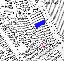
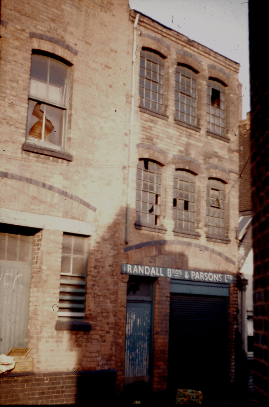
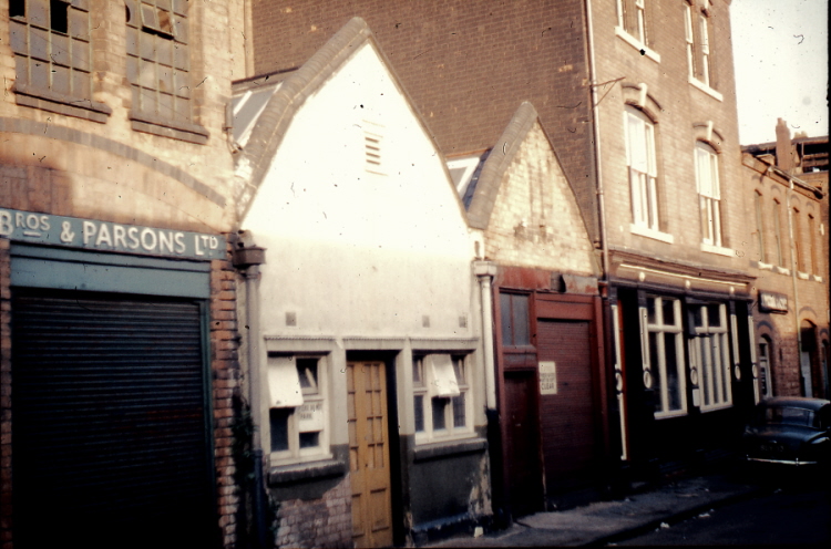
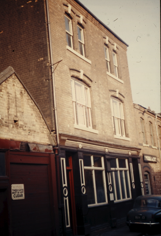
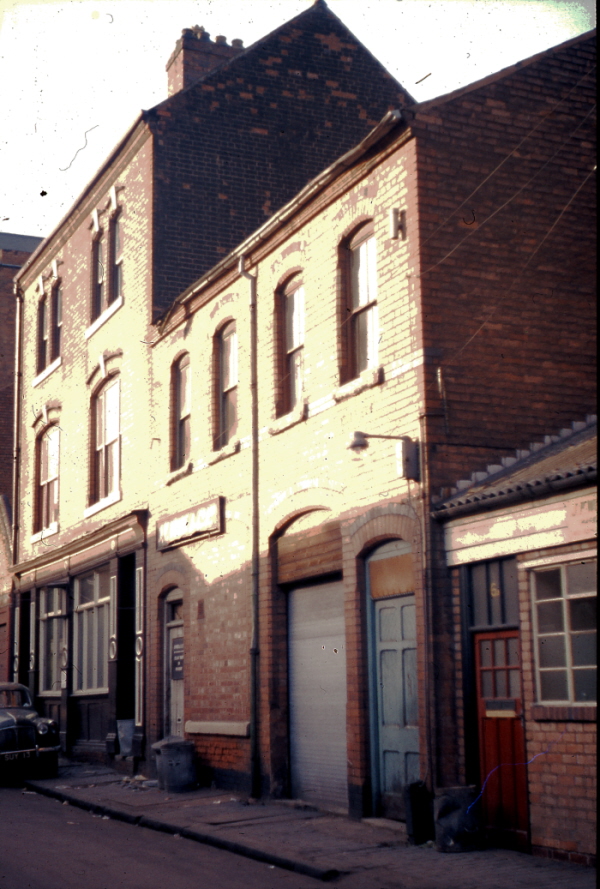
In 1971 the street looked a bit different than the previous photo, which i would estimate was probably the 1930s. I think there may have been some bomb damage in the war. Below is a map o the street, and where I think the photographer was in the previous photo is marked with a red arrow. There then follows some pictures taken going up the north east side of the street from Upper Dean St. Near the far end (photo 22B) is the back of Randall & Parsons, fruit merchants. In Jamaica Row they occupied the first 2 plots of the block, so i expect the building to the left of the one with the sign was also occupied by them. Photo 21B shows the buildings to the right, including what is obviously a pub, the back entrance of Brooks Vaults. When first built it was named the Criterion, but was Brooks Vaults by the time of Phil's photo, in which I guess the pub entrance is by the outside lamp. the vaults are marked in blue on the map. A similar photo (no 20B) follows, in which J.V.White & Co, fruit salesmen is seen to the right of the pub. This is listed as No 8 market st, while no 19B moves a little further up the street.


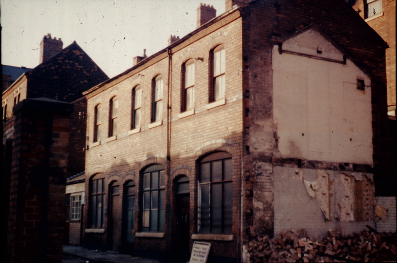
Going further up the street (photo 18B), and then comes a piece of waste ground, and photo 24B shows the back of the buildings in Jamaica Row behind that ground. Lastly no 23B shows one building (just) remaining on the south west side of the road towards Bromsgrove st end, with the buildings of Bromsgrove st being demolished in the background. I think it likely that the building in Market st in this photo is the building slightly behind the cart on the 1930s photo. The one this side of it with no door may be the one on the left of my photo with a doorway which has been largely demolished, the doorway being added later


Dennis Williams
Gone but not forgotten
Wow. Simply stunning mike, priceless memories and recordings, many thanks for sharing what must one day surely form part of a Book? You never let us down. That area of the Markets and Bull Ring I find absolutely fascinating, and there are so many more little nooks and crannies still to come...
he said hopefully. Got any more you can share of say, Mark Lane, Lease Lane etc?
Meanwhile, harking back a little while when Paternoster Row came up, and we wre discussing it's most probable links to the Printing trade? Came across this when researching the Birminghan Riots of 1791. Seems to prove the link nicely.
AN AUTHENTIC ACCOUNT OF THE DREADFUL RIOTS IN BIRMINGHAM, OCCASIONED BY THE CELEBRATION OF THE FRENCH REVOLUTION, On the 14th July, 1791, WHEN THE PROPERTY OF THE INHABITANTS WAS DESTROYED TO THE AMOUNT OF Four Hundred Thousand Pounds.
CONTAINING
Extracts from a Number of Private as well as Public Letters. A faithful Copy of Dr. PRIESTLEY’S Letter to the Inhabitants of Birmingham; also of the Hand Bill signed and distributed under the Direction of LORD AYLESFORD and several of the Inhabitants; of the Inflammatory Hand Bill distributed previous to the Revolution Dinner; and a Letter from W. RUSSELL, Esq. wherein is a more accurate Relation of the Proceedings at the Hotel, than is given in any other Account whatever.
London: Published by H. D. SYMONDS, No. 20, PATER-NOSTER-ROW. 1791. [Price One Shilling]
mike i dont know how far you have got with renovating your 69/73 thread but i cant seem to find it..wonder if you could bring it to the top of the main page please..
to anyone who may not have seen all the photos mike took during those years they are pure genius...and coupled with all the info mike writes up for each photo makes them invaluable to the history of brum...unfortunately when the forum was hacked last year all the images were lost so i wish you well in re posting them all mike...cant wait to see them again..
lyn
Lyn
The thread is at https://birminghamhistory.co.uk/forum/showthread.php?t=23229 . I have only done 3 pages son far. Am correcting and adding some to the text as I go along. Will try & speed it up. Am a bit reluctant to bring it to the top until it is completed, as it still looks a bit bare.
Phil
As i understand it local books like this you have to show a physical copy to the local manager before they will stock it. this is the problem with me not living close.
ok mike ...i would think this task will take you some to complete yet..good luck with it..i will have a look later at what you have done so far...if ever you change you mind about a book i am only to happy to do any leg work here in brum for you..
lyn
lyn
sylviasayers
master brummie
Thanks to Dennis and Mikejee for posting the maps showing Chapel Street. On the 1881 my g. grandparents Henry and Rosehannah Daley were living there in a lodging house with some of their younger children including my grandmother - I don't know the size of the house but 23 people are listed as living there on census night. The address is given as 27 Chapel Streeet, Mun. Ward St. Bartholomews. At 28/29 Chapel Street, there was a Bottle Warehouse.
Sylvi
below is \ map c 1889 of chapel St. I am only certain of a few numbers, and jhave out them in. Numbering was consecutive, going up one side and down the other. I am not certain , but think it most likely that no 27 was the house on the corner of Bishop St , nearest the Crown & anchor
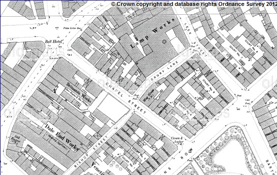
below is \ map c 1889 of chapel St. I am only certain of a few numbers, and jhave out them in. Numbering was consecutive, going up one side and down the other. I am not certain , but think it most likely that no 27 was the house on the corner of Bishop St , nearest the Crown & anchor

Dennis Williams
Gone but not forgotten
I don't think we've had this Narrow street on before - WINDMILL STREET. Here's a couple of shots inevitably featuring (to me) it's greatest asset, The Duke of York. It once led to the old Windmill of Holloway Head. Now the bottom end was swept away for the Bristol Street widening, there are still fading remnants left, as this Google shot shows...


Phil
Gone, but not forgotten.
Dennis
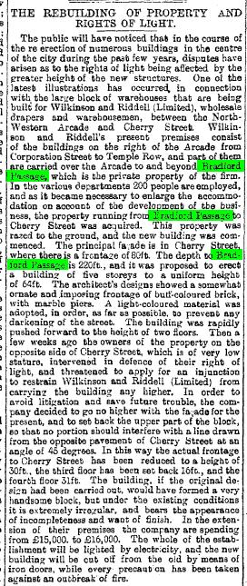
Heres one I was reminded of the other day whilst searching for something on Temple Row, "Bradford Passage" that ran from Temple Row to Corporation St. I'm guessing that it was older than the nearby North Western Arcade that it ran parallel to. Which the opening of would have made Bradford Passage surplus to requirements. I know that I don't think I ever used it before it was swallowed up by Rackhams new building in the 60's.
Sadly I have no image of this passage itself, but I can manage a map showing it's position, the Corporation St end and the Temple Row end.
Attachments
sylviasayers
master brummie
Mikejee thank you for the map showing Chapel Street again, it is so nice to be able to place where your ancestors lived.
Dennis in 1954/55 I worked at Boulton & Paul in Windmill Street, I only have vague memories but I'm pretty sure it was a very short street maybe a cul-de-sac. It was a branch depot for B& P the aircraft manufacturers, and I think the head office was in Norwich.
Dennis in 1954/55 I worked at Boulton & Paul in Windmill Street, I only have vague memories but I'm pretty sure it was a very short street maybe a cul-de-sac. It was a branch depot for B& P the aircraft manufacturers, and I think the head office was in Norwich.
Dennis Williams
Gone but not forgotten
Mikejee thank you for the map showing Chapel Street again, it is so nice to be able to place where your ancestors lived.
Dennis in 1954/55 I worked at Boulton & Paul in Windmill Street, I only have vague memories but I'm pretty sure it was a very short street maybe a cul-de-sac. It was a branch depot for B& P the aircraft manufacturers, and I think the head office was in Norwich.
Great story Sylvie, but I'm afraid my memories are much less savoury...if you look at the Mikejees map in Post 769, and the Google shots below, you will notice that what's left of Windmill Street is one half of a right hand triangle with Exeter Street, which did, and still does, exit on Holloway Head. The Google van must have loitered in the peppermint Palace Sauna Bar (cough,cough) for quite some time, as if you use the little orange man to go UP Exeter Street now, the Bier Keller on the corner, has magically metamorphosed into a Purple Painted monstrosity of VERY dubious character. GOK why that young lady was running away from...but when I was a lad, Phil told me that the Club on that corner was a 'Private' all-day drinking Club, which then became a Strip Club. Heaven only knows how he knew that. Odd.


Last edited:


