-
Welcome to this forum . We are a worldwide group with a common interest in Birmingham and its history. While here, please follow a few simple rules. We ask that you respect other members, thank those who have helped you and please keep your contributions on-topic with the thread.
We do hope you enjoy your visit. BHF Admin Team
You are using an out of date browser. It may not display this or other websites correctly.
You should upgrade or use an alternative browser.
You should upgrade or use an alternative browser.
Old street pics..
- Thread starter Astoness
- Start date
 irate:
Oisin this is what Wikepedia says
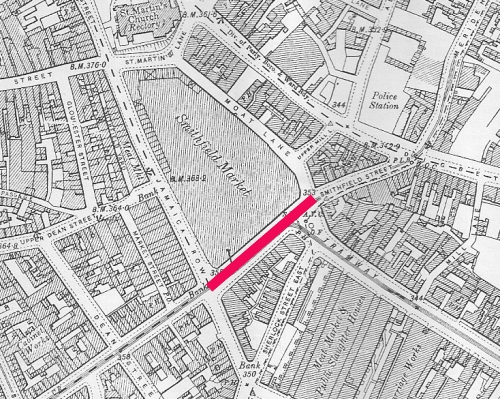
Today, the area has completely disappeared. Smithfield Markets expanded to become the Bull Ring Indoor Market was rebuilt and opened before the redevelopment of the Bullring Shopping Centre. Outdoor markets are held outside the entrance. The Bull Ring Rag Market was demolished as part of the development and a multi-storey car park was constructed. The markets adopted the name of the Bull Ring and lost the Smithfield name. The original site of the Smithfield market is now Moat Lane car park. Smithfield Street, which connected Bradford Street (then Moat Row) to Digbeth High Street was renamed Mill Lane.[SUP][11][/SUP]
There are very few reminders of the existence of Smithfield. Smithfield House, an office building with ground floor retail, once occupied by Reddingtons Rare Records,[SUP][12][/SUP] bounded by Upper Mill Lane, Moat Lane and Digbeth High Street is directly opposite the site of the old market. Inside the new multi-storey car park on Pershore Street is a walkway called Smithfield Passage.
The name of Moat Lane is a reference to the moat that once encircled the manor house on the site.
Phil
Gone, but not forgotten.
Moat Row was a continuation of Bromsgrove St from Jamaica Row down to Smithfield, this photo taken in 1886 was taken from the corner of Bromsgrove St. Once again I know that Mikejee has a more recent photo taken by himself just before demolition.
Attachments


sospiri
GONE BUT NOT FORGOTTEN
I remember it from the end of the war onwards. I presume the bridge had by then been made higher to ensure it wasn't destroyed in flooding. It's roughly the same height now, except that it's now steel rather than timber. I can also remember when there were cattle in the field on the right and a bit of barbed wire was strung across the right hand side of the ford to prevent them straying into the road.
Maurice
Maurice
cookie273uk
Gone but not forgotten
berniew that TS,41 in bottom RH corner could be year 1941, just a thought. I was 11 in 1941 and those are the stlye of clothes we would wear Eric


View attachment 88680 Corner oif Ickneild Square and Freeth Street
Corner oif Ickneild Square and Freeth Streetbrummie nick
master brummie
Reference picture #3209 I remember those almshouses in Warner Street there was a gateway in the wall to enter them.
Nick
Nick
Oisin
gone but not forgotten
But what's that lady got on her head, a chamber pot?Reference picture #3209 I remember those almshouses in Warner Street there was a gateway in the wall to enter them.
Nick
There's some cracking pictures there Bernie. I particularly like the composition of #3207 and the lighting in #3210 is incredible.
brummie nick
master brummie
On this Link there's some inside pictures of the almshouses in Warner St.
https://www.photobydjnorton.com/GTC/TheRetreat/DowellsRetreat.html
https://www.photobydjnorton.com/GTC/TheRetreat/DowellsRetreat.html


