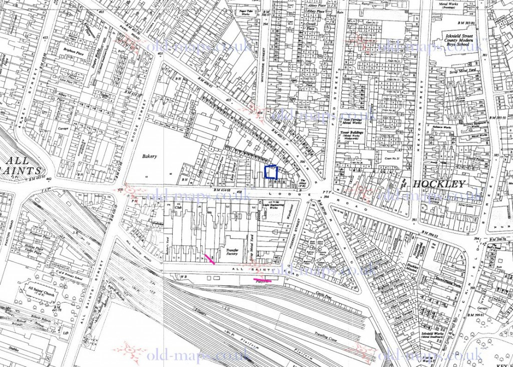
• Welcome to this forum . We are a worldwide group with a common interest in Birmingham and its history. While here, please follow a few simple rules. We ask that you respect other members, thank those who have helped you and please keep your contributions on-topic with the thread.

    We do hope you enjoy your visit. BHF Admin Team

New unseen photos with no locations

Thanks Viewfinder - so subtracting Mike's height from the other heights we have heights of 4.4 and 50.4. I have some trig tables somewhere but I vaguely remember some rules called 'similar triangles' so I might try that after I have had my tea unless someone has already worked it out ...
friendly_wink.png

Enjoy yer tea, oldMohawk! Remember that we can see the top floor of the tower, so the sight-line ends about 3 metres below its full height, therefore roughly 49 metres from the ground.
 
Presumably, if there was a direct line from Mike's eyes to the top of the derelict house to the top of the tower then the distance from the tower to Mike would be 114.5 metres. This is based on there being a rate of rise in height of 0.44 metres per metre in length (4.4 metres per 10 metres length). Is it more complicated than that and is that distance feasible? Dave.
 
Hi farmerdave - I get roughly the same with my calcs which put Mike standing roughly 110 metres away in or near All Saints Rd if the tower is Norfolk Tower, and near Lodge Rd if the tower is the other one near Ford St. It's name plate has dropped off so I don't know its name. Summat don't seem right .... he seemed to be standing further away .... but photos are deceptive. :)
 
Last edited:
It seems reasonable to me ( my last effort in trigonomtry was about 1962). by the was the map was 1955, not 1855. My error, which I have corrected. Nelow is a map c 1950 with norfolk tower in blue and lines to the south at about what I estimate is about 110 metres.

map_c_1951_All_saints_road__lodge_road__area_with_norfolk_tower_and_110_metres_line.jpg
 
Here is a view of a block of flats looking from the top of Ford Street which would show the flats probably in Heaton Street. So are the houses on Icknield Street which does dip down towards Hockley Brook. Is the large chimney in the background Rabone Chesterman?

t. The Flat2 1.JPG
 
Last edited:
It seems reasonable to me ( my last effort in trigonometry was about 1962). But the map was 1955, not 1855. My error, which I have corrected. Below is a map c 1950 with norfolk tower in blue and lines to the south at about what I estimate is about 110 metres.

map_c_1951_lodge_road_area_with_norfolk_tower_and_110_m_line.jpg
 
Last edited:
Here is a view of a block of flats looking from the top of Ford Street which would show the flats probably in Heaton Street.
Hi Carolina - that pic confirms that Mike was in the area and a link to a very similar view of the same shop in second pic dated 1967 in one of Lyn's posts here https://birminghamhistory.co.uk/forum/showthread.php?t=38737&p=445964#post445964
The other pic is dated 1967 and unlike Mike's pic has a police telephone on the corner and a window bricked up !
 
Cornwall Tower, and was demolished a few months ago. Here is a piece about the fate of Norfolk Tower:

https://www.birminghampost.co.uk/ne...-launched-birmingham-tower-demolition-8278949

All I remember of Trigonometry is SOLD_CALD_TOAD! This is not quite "on Thread" but reading that these "new" blocks had been demolished I looked at some of my ancestor's address's around Birmingham in the 1911 census and find three of four properties are still standing and how new would they have been in 1911?
Namely 229,Percy Rd, Sparkhill. 31,Abbotsford Rd. Sparkbrook. 47,Third Avenue, Small Heath. The one that has been demolished was 64, Church Lane, Aston.

What's this say about modern building construction?
 
All I remember of Trigonometry is SOLD_CALD_TOAD!
My three words were SOLO, COAL, and TOAD. Sine equals Opposite over LOngest. COsine equals Adjacent over Longest, and Tangent equals Opposite over Adjacent. These are for remembering sine, cosines and tangents in a right-angled triangle. Sorry to be a bit off-topic. By the way, devonjim, we went to the same school but perhaps had different Maths teachers. Dave
 
Hi viv
Many thanks for the two pictures you have put up for comparison
Now looking at the two comparisons first closest to the st peters church would have been the closest would have been Camden tower/Camden house
I had a relative whom lived in there from day one and secondly the one facing behind the church and as our friend said according to the angle
And according to the angle to me it confirms that what I thought of before pursuing your Picts the one at the angle of st peters church was in fact
On the very corner of spring hill and that block was built at an angle facing the library and long before they built the florin pub
Just along on the percent which was adjoining the library then they built Tescos across the road then they built tesco at five ways
And eventually they widen the road at spring hill I spoke to my wife and she agreed there was two blocks around springhil
I myself did say there was one on spring hill right on the corner I beleive the turf pub had been demolished priory to that
Also I would like to say that when you walked along clissold street and continued along it changed to clissold passage where upon you come out on
Dudley rd end on entering dudley road you turn left down to spring hill after area yards along leaving the canal as it ran along clissold passage
That's where the open planned area was going back towards Rosemary street and passage then they started to build the front house on dudley red
Down to the college red and where the college pub was then they built further back and around up college road as a lot of our locals knew it
They later built a block further back up by Goode street by the ice skating rink that also went in clearance
The next block which still stands today was on was was called the parade later became summer hill right next to the summer hill DHSS offices
Best wishes Alan,, Astonian,,,,,
 
I think its Lyn's turn, but as I have this ready, will post ti. Phil thought this was around either George st or Charlotte St. anyone support this or have othe rideas?

17C_scene_of_desolation_near_Summer_row.jpg
 
thanks mike...well i know thats the post office tower lol....detective work needed

lyn
 
This is from Charlotte Street with the office block and PO a tower. . Viv.
 

Attachments

  • image.jpg
    image.jpg
    182.5 KB · Views: 40
I think I can see these buildings in Mike's pic and in an up-to-date pic as I stand in Augusta St but probably not exactly where Mike stood.
17C.jpg_Augustinemod.JPG
The office block in the image below marked with the circle might be the office block in Mikes pic.
image3.JPG
 
Last edited:
Mohawk I think you and Lyn have got it. If I was about in the centre of what is now the Design centre, half way between Northampton st and Vyse st, I would see those buildings at about the right angle, and the corner of the Big Peg would show up about there. It was taken immediately after some on Hockley St , so that would fit in very well. Does else anyone agree?
 
Last edited:
Mike

I think that is as close as anybody is going to get, well done to Lyn and Phil.
 
I've altered the title on this one. Lyn, Have you got another ready, or shall I put another on?
 
This one was on the film roll immediately after the last one, so may be in the same area, certainly the devastation seems similar.


18B.jpg
 
Am I reading this picture correctly? The stem is difficult to discern, but you have focused on the bloom of a poppy, a symbolic struggle for renewal among the ruins of an apocalypse. Another strong picture for your book, Mike.
 
Hmmm .... no tower blocks and no post office tower, only that building on the right to give a clue and it might have been demolished .... :)
 
Last edited:
Yes mowhawk
If I am correct that high building on the right side of the picture and whom ever took that picture was looking from the left hand side of the picture
The high rise original flats they built is the very first block they built within that area
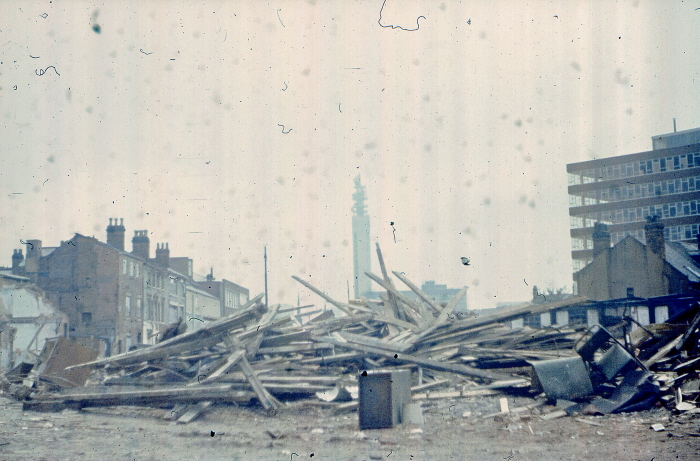
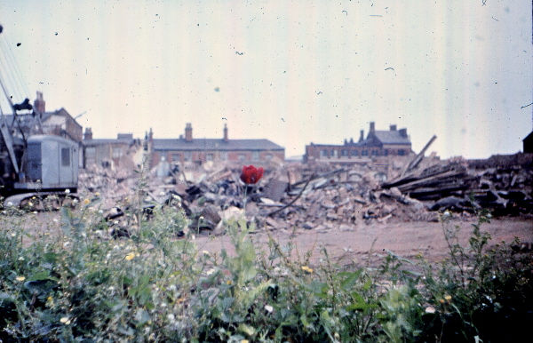
The street with the rubble was old ryland street and straight across those flats was created within ledsam street and right across Vincent street
Almost all the way down the road and they was behind the Ladywood road
The street with the rubble is old ryland street if you was to walk up sheepcote street to the top
Passing the round house come to the corner of ledsam street you can walk straight up that road walking through what used to be
Flats like those you see and maisonettes turn left at that school which stands there today down that road
Is where that horrible blocks was at that bottom of the road stands tescos today and there garage
To make it easier for our experts with there planns and maps as I know longer lived in brum
And in my younger days as I have said some times of my momorys of Ladywood growing up as a kid
And tatting and scouring all those bombed out house as they war I recall all the demo and rebuilding that complete area
And they was the first type of flats to be built in the early
If you walked up Vincent street today you will see the community centre of today
The road I'd facing was where that high rise was and orignaly also the same type was at the bottom of ledsam street
The complex you see there today are the second remodeling of the area
And yes I believe its Charlotte street/ryland street looking across to the old and first ever complex of housing ever built by the city planners.
Have a nice day best wishes Alan,, Astonian,,,,,,,,
 
Back
Top