Seanyb1986
master brummie
The money for the new buildings i believe is from investors in singapore, they dont care for local history, they would have me just rip it all up

It fairly common knowledge that when Birmingham had a large Manufacturing and Brewing industry the amount of water abstraction taken by these industries by default kept the water table in check.Old news from 2008, but may be of interest. Birmingham rising water table…
Birmingham on flood alert as water table rises
Birmingham’s water table is rising to dangerous levels and the city is at risk of being submerged under regular floods unless urgent action is taken, it has been claimed.www.business-live.co.uk
Just wondering what sort of obstructions could be 8mtrs deep ?The area is being developed for 2 new skyscraper buildings, as seems all the rage in birmingham now, unfortunately i think all previous obstructions, whatever they may be, will be recorded and removed, to be replaced by stable crush infill, this could be as deep as 8 meters in places i believe, i dont know how we will deal with the spring/borehole but it cant stay where it is, there is probably a modern way to cap it off
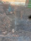
And are these steps to a cellar or underground structure? It also occurred to me that the street level would once most probably have been below the existing street level. So I’m a bit confused about what I’m looking at ! Viv.In this picture, the wall running below the steps runs the length of the site, nearly in line with the divide of the opposite buildings, the bit of the wall you see here is topped with slate????
not being an expert viv my first thought was the steps lead up from a cellar maybe will know more once the report comes out which i would think wont be just yet...my thought was that the street level has not changed in over 100 years this is looking at the age of the building on the other side of well lane...the dig is opposite those buildingsAnd are these steps to a cellar or underground structure? It also occurred to me that the street level would once most probably have been below the existing street level. So I’m a bit confused about what I’m looking at ! Viv.
 www.google.com
Cellars, bunkers, drainage pipes,Just wondering what sort of obstructions could be 8mtrs deep ?


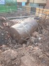
you may need a pair of swimming trunks seanThe water wasnt that high when i left on friday . Interesting day for me tomorrow


viv there is a map on post 25 showing the locations of the spring and the wellDo we know precisely where the Digbeth Spring structure illustrated in post #12 was located ? And are any the remains currently being uncovered part of that structure? Mike also posted this advert on the Goffe’s thread. The advert labels the image as “View of Digbeth Well” which looks to me like it’s sunken much below ground level. It was at the time drawing water from a depth of 400ft. Also wondered if any curved bricks have been uncovered ?
Reposting Mikes post #12 for ref below with the clearer image of the well. Viv.
View attachment 175542
Viv.


Roughly yesGas Engineer Tank Over ? See Viv’s map in post 81.
Is the slaughter hose, just S of the well, where the horn was found ?