I lived in 38 which was opposite the park. 1955 to1957View attachment 90276uncle albert... you know when you were looking at the photos earlier of the lozells area well did you notice this one taken at the bottom end of berners st..you can clearly see a bit of the park and the railings surrounding it...
lyn
-
Welcome to this forum . We are a worldwide group with a common interest in Birmingham and its history. While here, please follow a few simple rules. We ask that you respect other members, thank those who have helped you and please keep your contributions on-topic with the thread.
We do hope you enjoy your visit. BHF Admin Team
You are using an out of date browser. It may not display this or other websites correctly.
You should upgrade or use an alternative browser.
You should upgrade or use an alternative browser.
Berners Street, Lozells
- Thread starter davidfowler
- Start date
Just to add that the Wilson's lived at 213 Berners St, we were at 215.
good to see you posting again barrie...you take care
lyn
I was christened in the Church of the Nazarene on Berners Street in 1954, as we lived at 129 Berners Street until 1965. Would this be the church pictured do you think? I see it is listed as St Peters Mission Hall but wondered if the Church of the Nazarene took it over later? My brother Brian Farmer and his friend Les Evans also attended that church in the 1940s and 50s and went on to become ministers in the Nazarene ChurchYes, St Peter's mission Hall
Hi BarrieJust to add that the Wilson's lived at 213 Berners St, we were at 215.
I am the great-granddaughter of Mrs Wilson. Do you remember much about the family?
thanks Carol
Hi Christenehi wondering did anyone know my nan she lived in berner street number 113 her name was mary wilsonthe house was by the garage or coach place .i was born 1950 and lived there with nan my mom rosena and dad cyril and grandad of course i think my aunt clara uncle dan lived there to would be lovely to know if any one knew them thankyou .
I am the great grand-daughter of Mrs Wilson, but her name was Kate (catherine) not Mary that I am aware of, my nan was her daughter but through Bennett surname. I know Clara well as she is my nan’s half sister.
My nan’s name was Leah Alice Bennett born in 1909.
please contact me if you would like to, best wishes Carol
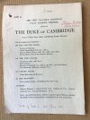
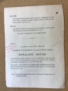
very interesting oldun...not sure yet if the sale is for the original pub or the new one built on the same ground....notice dated 1927 and from memory the new pub was built in the 1930s but i would need to try and confirm that when i have the time...somewhere on the forum i posted a photo of both the original and the new pub which is the one i remember walking past many times and in later life i did go in itThe Duke of Cambridge.
lyn
CaroleA649
proper brummie kid
I do not know if anyone can help me, I do hope so. In 1881, my Gt Grandfather, George Broughton, and his family lived at 7 Berners Street.
I know nothing about my extended family and would love to find anyone out there related.
His Mother was Mary Allen, whom I have noticed in some of the threads on this site. If anyone has any information or if there is any way I can share with you, please let me know.
I know nothing about my extended family and would love to find anyone out there related.
His Mother was Mary Allen, whom I have noticed in some of the threads on this site. If anyone has any information or if there is any way I can share with you, please let me know.
MWS
from Bham
Having a little trouble tracking him down. Is the address from a census or certificate?
Closest I could get was a George Thomas Broughton who married an Ellen Ann Allen in 1881. On the 1881 census (prior to his marriage) he is was living with his aunt, Mary Allen on Wheeler St (not far from Berners St).
There doesn't appear to be any Broughtons living on Berners St or any George Broughtons with Mary Allen as a mother.
CaroleA649
proper brummie kid
Hi, Thank you for your swift response, I think the penny has just dropped. Both the mother (widowed). and daughter were both called Sarah. What I now need to establish is was Mary Allen her sister, sister-in-law or mother.Having a little trouble tracking him down. Is the address from a census or certificate?
Closest I could get was a George Thomas Broughton who married an Ellen Ann Allen in 1881. On the 1881 census (prior to his marriage) he is was living with his aunt, Mary Allen on Wheeler St (not far from Berners St).
There doesn't appear to be any Broughtons living on Berners St or any George Broughtons with Mary Allen as a mother.
I am looking at the 1881 census and Sarah Broughton is listed as head of the household.
My problem has been sorting out which ones are mine as the multitude of children all seem to use the same names as their siblings so you end up with about 25 Johns, Alfreds, Sarahs and Williams. I am trying to establish which are actually mine!
I did manage to wipe half of my tree by accident this morning so decided that if I am to re-build it, it might as well be accurate. It would be nice to be able to make contact with others from the family who could confirm their place in the tree and where I fit it.
Many regards,
Carole
brummy-lad
master brummie
Kathtap217
proper brummie kid
Thank you John, I am still getting used to this site, not sure if I have managed to thank everyone but ticked the appreciate buttons on the forum page. I have read all the posts, absolutely fascinating, my great grandfather James Hill was a landlord for a short time of a corner pub, not sure if it may have been the Gunmaker. Maybe.
Would you be able to show me where 121 Berners Street was, please?Samantha
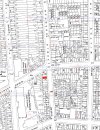
Below is a map c1950 of all of Berners St with no 139 in red and marked.
View attachment 119932
Also, is the map available online? (I'd love to get a sense of where other streets were in relation to where I used to live).
Thank you.
The 1950s maps used to be online , but the site closed down , as they decided they were not making enough money from it. Some members saved areas of it before it closed down, and in the future hopefully it will be available from the National Library of Scotland website, which at present only has Scotland, London and a few parts of the south of England, but is planning to expand the cover.
The map you refer to shows no 139 in red. A little below it no 123 is marked on the original map. No 121 is the house just below 123
The map you refer to shows no 139 in red. A little below it no 123 is marked on the original map. No 121 is the house just below 123
Thank you very much for your speedy reply. I'll download the copy with 123 marked on it.The 1950s maps used to be online , but the site closed down , as they decided they were not making enough money from it. Some members saved areas of it before it closed down, and in the future hopefully it will be available from the National Library of Scotland website, which at present only has Scotland, London and a few parts of the south of England, but is planning to expand the cover.
The map you refer to shows no 139 in red. A little below it no 123 is marked on the original map. No 121 is the house just below 123
brummy-lad
master brummie
Richard Dye
master brummie
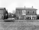
What years might this be?Corner of Berners Street and Lozells Road.
There appears to be another thread for Berners Street called 'Berners Street.'
brummy-lad
master brummie
I would think around 1970, the Vauxhall Viva in the picture was produced between 1963 and 1979. Looks like a Ford Cortina Mk III in the background (1970-76)What years might this be?
Richard Dye
master brummie
Yes, I thought early’70s based on the cars and looks like a newer roof…..I would think around 1970, the Vauxhall Viva in the picture was produced between 1963 and 1979. Looks like a Ford Cortina Mk III in the background (1970-76)


