• Welcome to this forum . We are a worldwide group with a common interest in Birmingham and its history. While here, please follow a few simple rules. We ask that you respect other members, thank those who have helped you and please keep your contributions on-topic with the thread.

    We do hope you enjoy your visit. BHF Admin Team

ANN STREET CITY CENTRE

The file manufacturer is, indeed, Heptinstall and Lawledge (just Heptinstall up until 1822/1823). In fact, the Heptinstalls and/or Lwledges occupied 27 Ann Street from 1789 until the 1870s when the area was redeveloped to include the Council House. At that time, the business moved to Granville Street. For anyone who is interested in file manufacturing, I have previously attached a leaflet on Heptinstalls to a file-making thread, but if anyone wants more information on the family please contact me.
Does the attached help identify the view?
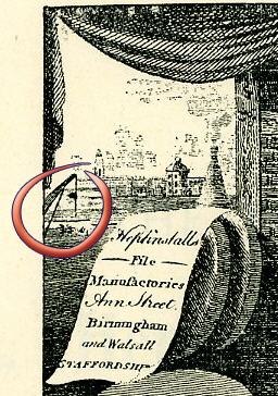
heptinstall_lawledge_file_makers_partial.jpg
 
Last edited:
The church through the window must be either St Philips or Christchurch.

I would like to know how the grindstone is powered. I cannot believe that that is a waterwheel on the right as the area is on top of a hill so I am assuming that it is a flywheel from a steam engine. Anyone got any ideas
 
Have had a hunt through my other notes and the image is from Bisset's Magnificent Guide or Grand Copper Plate Directory for the Town of Birmingham, 1808 [From Birmingham Central Library]

The caption reads reads:

"Hepinstall and Parker’s File Manufactory, Ann Street, Birmingham and Walsall, Staffordshire

This engraving shows two images of file makers and grinders at work. The top compartment shows a workman using a water-powered grinding wheel. Through an open door, Birmingham Canal Navigation Offices and canal wharves can be seen. The second picture shows a seated row of file makers at work and a man manually operating a grinding wheel. "

[William Parker was Joseph Heptinstall's brother-in-law]

Does this information give us a fix on which side of Ann St number 27 was? I have never been apply to accurately position it.
 
Thank you, Leslam. It had not occurred to me that Birmingham centre would have been so open at the time the engraving was made & that there would be an unrestricted view to Old Wharf in Paradise St! Looking at Mike's map (thank you, Mike) & taking into account what you say about the reason for the move from Ann St, Hepinstall's must have been on the north side & up towards the Council House. I'll be looking with extra interest at the pictures of Ann St posted earlier. Of course if anyone can place Hepinstall's more accurately, please step in.
There was a school on the south side next to Christ Church. Has anyone got a picture of Ann St School? I have seen one somewhere showing an internal view of a classroom, children & teacher but cannot remember where, other than that it must have been online.
 
I was wrong about the waterwheel then although I am still puzzled about how you can get a sufficient head of water to power a waterwheel when you are on the top of a ridge.

From the info in post above I would say that the church was Christchurch, the domed building was the canal offices and that the works would be on the north side of Ann St which confirms that the firm would have had to move out for the building of the Council House
 
With everything crossed, I've just had another look at the 1841 census. I had always assumed (bad idea in this game!) that the numbering of Ann St would have started at the Town Hall end - but it didn't!
I have just stepped through the images from 27 Ann St in both directions. The Town Hall is clearer indicated on the 1841 returns as coming after 41 Ann St. At the moment I can't spot a mention of Christchurch to help further
So 27 comes somewhere in the middle. I need to spend some time with the print outs to see if I can work out the enumerators route; there were a number of back-to-backs in one section of the road, so it ought to be easy to identify those on a detailed map.
Thanks to all for inspiring me to investigate further!
 
Hi Mike,so it would appear to be one these premises,and the artist must have used a degree of artistic license when showing the view from the window.
Moss.
 
Yes Moss that certainly seems so. I've been looking for where the kiln that seems to be in the picture might be and the only plce i can find that there might be one in birmingham (pottery, earthenware or glass manufacturers) are in vyse St, Steelhouse lane and New St. None of these places seem to fit the view from the firm
mike
 
Good strategy, Mike.
The school on the map shown earlier on this thread was Ann St School. The premises were described as "spacious & convenient". There were over 200 children on the roll, with summer attendance at 180 and winter at 140. The children were too young to attend other schools and it was considered that they would benefit from instruction, separation from bad influence & removal from neglect of working parents or those involved in household duties. As one of a number of infant schools in Birmingham Ann St Sch was supported by donations & subscriptions.
Source: An Historical Sketch of Birmingham Yates 1830.
 
Thanks Lyn.What a great thread this has become,i doubt that there were many of us who knew of Ann Street until this thread started.
Moss.
 
I understand that Ann was one of the members of the Colmore family after whom several streets in this area are named ie Edmund St, Charles St before it became Gt Charles St
 
hi david thanks for that info..didnt know that...just goes to show one is never to old to learn...

moss i must admint up until i posted those pics of ann st i had not really given much thought to what the city centre must have looked liked before it is now...i now find it fascinating and ive been racking me brains as to where i posted some old city centre pics prob early part of last year.....will keep looking for the thread....

lyn
 
most annoying is this shirl...me brains are well and truely racked at the min...still i will press on...

lyn
 
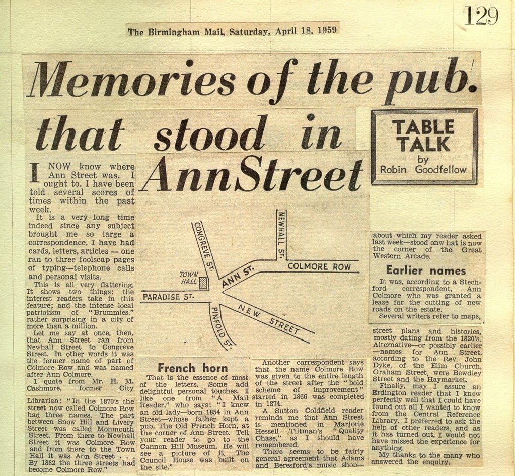
I found the attached in a scrapbook that my husband's grandfather kept (and indexed!). It has lots of things to do with the City - as well as all the family announcements.

Ann_Street.jpg
 
Last edited:
hi leslam..what a wonderful cutting..thank you so much for posting it...so i wonder then the the old french horn pub is the building on the corner of my pic 2 which is on post 1.....

lyn
 
Drake in his book Picture of Birmingham wrote of Ann St " This part of the town has lately witnessed great alterations. The old & poor buildings which formed the south eastern side of Ann St have been removed, the surface of the street lowered & the ground between Ann St & New St, which had been occupied by gardens, laid out for building on. It is made a condition, by the proprietor of the land, that all houses & other errections shall be of stone, or coated with its semblance Roman cement."
So that would have amounted to an early planning scheme.
 
It is interesting to compare this pic of Allins Cabinet & other buildings with the earlier one on post 24. On the face of it there appears to have been some changes on the Allins side of Congreve St.
 
yet another gem of a pic shirl....i still cant track down where i posted the old brum pics...the cherry st one was great...not happy...

lyn
 
Thanks, David.
1) Ann St, Christ Church & New St.
2) The Colmore pic shows a large squarish building. I do wonder if this was the former Ann St School. I have looked in early directories for obvious mention, without success, and Griffith fails to mention Ann St School in his 1861 book A History of the Free Schools. This is odd, because on the map Mike posted it looks as though the school had a large footprint.
 
Shirley I think, if you mean the square building in the centre of your right hand picture, then this would have been too far up to have been in Ann St, which ended at Newhall st. In fact I think it would be the Blue coat school , the position of which is shown on post 7 of https://forum.birminghamhistory.co.uk/showthread.php?t=9516. Anne St school does appear, though not under that name.The 1845 and 1849 PO directories list in Ann St , in about the right position:
47 British & Foreign School, Miss Mary Ann Harris, mistress
48 Infant School,Mrs. Sarah Smith, mistress.
Either could be the school in question.
In 1855 it has become:
47 Temperance Hall,Benjamin Blackbam, secretary
48 InfantSchool,Mrs.SarahSmitb,mistress
The infant school is still there in 1862, but has gone by 1868. When the street was incorporated into Colmore Row 48 Ann St became 118 Colmore row and 47Ann St became 120 Colmore Row
Hope that is helpful
mike
 
yippee...just going through me old mags again and ive found the pic of cherry st...will scan it...start a new thread and post...

lyn
 
Back
Top