DavidGrain
master brummie
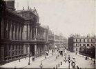
VivIn the 1860s and 70 s Ann Street must have been an important commercial street. The Registrars Office and the Patent Office. There was an Emigration Office, particularly to New York and Canada. The branch office of the RSPCA (mentioned earlier by Mikejee) were also located there. Viv.
Source for all newspaper extracts: British Newspaper Archives.
Do you have any information about the location of Lloyds Bank at that time. A friend of mine has an old cheque drawn on Lloyds Bank Ann Street Birmingham and we were wondering if it was at the location next to Eden Place which became Lloyds Bank Colmore Row.
David


 (Henry Joseph Whitlock) 1867.png")
