-
Welcome to this forum . We are a worldwide group with a common interest in Birmingham and its history. While here, please follow a few simple rules. We ask that you respect other members, thank those who have helped you and please keep your contributions on-topic with the thread.
We do hope you enjoy your visit. BHF Admin Team
You are using an out of date browser. It may not display this or other websites correctly.
You should upgrade or use an alternative browser.
You should upgrade or use an alternative browser.
Snow Hill Station
- Thread starter Alf
- Start date


sistersue61
master brummie
I can remember it being like this Lyn, must have parked there at some point with dad I should think, and definitely walked by it, I think taking a neighbour to the old Eye Hospital.
Sue
Sue
I know from earlier posts that the railway line went out under the Great Western Arcade, so did the line in the other direction also go into a tunnel? Lyn's view towards Constitution Hill shows how high up the station would have been, so I'm assuming maybe there was a tunnel out that way. Or was Snow Hill a terminus? What a great booking hall that was too, pity it wasn't re-cycled (1960s New Street Station could have done with a but of that to add character!) Viv.
I know from earlier posts that the railway line went out under the Great Western Arcade, so did the line in the other direction also go into a tunnel? Lyn's view towards Constitution Hill shows how high up the station would have been, so I'm assuming maybe there was a tunnel out that way. Or was Snow Hill a terminus? What a great booking hall that was too, pity it wasn't re-cycled (1960s New Street Station could have done with a but of that to add character!) Viv.
I remember in the 10 years before Snow Hill finally closed in 1972 (the last line open being that to Wolverhampton) and travelling from Wolverhampton myself, that there was indeed a super-size tunnel so well-know it has its own page on Wikepedia
https://en.wikipedia.org/wiki/Hockley_Tunnels
Quite foreboding it was too, since the approach from Wolverhampton comprised a several hundreds yard long bricked-in cutting which made everything from Winson Green seem like quite a scary journey!
ellbrown
ell brown on Flickr
There still is a tunnel that goes from Snow Hill to Jewellery Quarter!
Here's a pic I took yesterday from Northwood Street / Livery Street with the completed 2 Snowhill
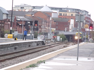
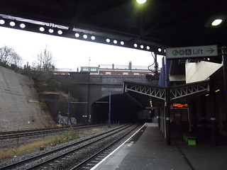
Here is a view from November 2011 of a Class 172 London Midland service emerging from the tunnel. You can see that bridge from where I've taken several photos from.
Other end of the tunnel from Jewellery Quarter Station
Here's a pic I took yesterday from Northwood Street / Livery Street with the completed 2 Snowhill
Here is a view from November 2011 of a Class 172 London Midland service emerging from the tunnel. You can see that bridge from where I've taken several photos from.
Other end of the tunnel from Jewellery Quarter Station
Brookfields Lad
master brummie
Quite foreboding it was too, since the approach from Wolverhampton comprised a several hundreds yard long bricked-in cutting which made everything from Winson Green seem like quite a scary journey![/QUOTE]
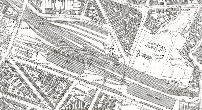
You will find the following link interesting. It's what was at the end of the tunnel(s) from Snow Hill to Hockley. A huge feat of engineering. Can't imagine how many bricklayers were employed.
https://warwickshirerailways.com/gwr/hockley_goods_part1.htm
You will find the following link interesting. It's what was at the end of the tunnel(s) from Snow Hill to Hockley. A huge feat of engineering. Can't imagine how many bricklayers were employed.
https://warwickshirerailways.com/gwr/hockley_goods_part1.htm
Thanks Bob. What an enormous goods yard in Hockley! There must have been a lot of goods that passed from Hockley through Snow Hill. Funny, I've only ever really thought of Snow Hill as being mainly concerned with passenger transport; holidaygoers, businessmen etc. It must have been incredibly busy in the late 1800s with all that traffic from the jewellery quarter. Did Snow Hill have a goods yard or was Hockley it's goods yard? Viv.
ellbrown
ell brown on Flickr
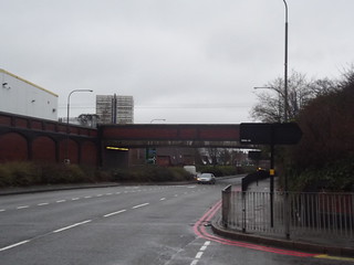
This is the other side of the bridge / tunnel entrance from Livery Street
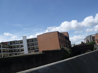
These shops are built over the tunnel at Vyse Street
A closer view of the Hockley No 2 Tunnel from inside Jewellery Quarter Station

Yeah the brick walls down here are impressive. Reminds me of the brick walls near Five Ways Station in Edgbaston.
These shops are built over the tunnel at Vyse Street
A closer view of the Hockley No 2 Tunnel from inside Jewellery Quarter Station
Yeah the brick walls down here are impressive. Reminds me of the brick walls near Five Ways Station in Edgbaston.
DavidGrain
master brummie
Viv. I think an earlier post on this tread showed the Goods Dept at Snow Hill. It was near the junction of Snow Hill and Gt Charles Street where I think you could see loading bays until recent times. However Hockley was the main goods station for GWR. I remember Icknield Street until the late 1980s where you still had all the bridges making a long tunnel for the street traffic. I can remember seeing freight trains moving through Snow Hill on the centre tracks but I assume much of the goods traffic went through at night.
DavidGrain
master brummie
 The new brickwork is also impressive. This is Icknield Street/ The whole of this streatch of road used to be covered by railway bridges for Hockley Station and Good Depot.
sistersue61
master brummie
I'd never really thought about how the trains crossed town from one side to the other, have found this fascinating!
The brickwork is spectacular even more so when you think that there wouldn't have been any of the mechanical aids there are today.
The long tunnel must be eerie, the one coming into New Street from Tamworth is enough for me, I imagine these would be longer than that one?
Sue
The brickwork is spectacular even more so when you think that there wouldn't have been any of the mechanical aids there are today.
The long tunnel must be eerie, the one coming into New Street from Tamworth is enough for me, I imagine these would be longer than that one?
Sue
ellbrown
ell brown on Flickr
I think the tunnel from Eastside to New Street is longer than the one from Snow Hill to the Jewellery Quarter.
A view on Google Maps of the Hockley Tunnels
As you can see some parts are exposed.
A view on Google Maps of the Hockley Tunnels
As you can see some parts are exposed.
Radiorails
master brummie
I used to walk beneath those multiple railway bridges, which were almost like walking through a tunnel, in Icknield Street. Being a bus enthusiast I enjoyed the roar of some of the Daimler buses as they passed through on the Inner Circle 8 route. Looking at the birds eye view of the area makes me realize how much that part of the city has altered. Apart from the Library in Spring Hill I doubt I would recognise very much today.
As a fervent cyclist around many of the Midland counties I got to see quite a few parts of Icknield Street (and its other names). I guess the one portrayed here was the most industrialized, inner city place I encountered and the beginning section adjacent to a farm in the Cotswolds the most hidden and rural one. Here it was only wide enough for one vehicle and was basically a track.
As a fervent cyclist around many of the Midland counties I got to see quite a few parts of Icknield Street (and its other names). I guess the one portrayed here was the most industrialized, inner city place I encountered and the beginning section adjacent to a farm in the Cotswolds the most hidden and rural one. Here it was only wide enough for one vehicle and was basically a track.
ellbrown
ell brown on Flickr
Found this video on YouTube dated from 2009 of going from Jewellery quarter to Snow Hill via the Hockley tunnels
Jewellery Quarter Snow Hill
There is also this one from Smethwick Galton Bridge to Birmingham Snow Hill
filmed in 2010 (on the now withdrawn Class 150's)
Jewellery Quarter Snow Hill
There is also this one from Smethwick Galton Bridge to Birmingham Snow Hill
filmed in 2010 (on the now withdrawn Class 150's)

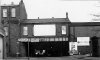
 bit off thread but heres 2 pics of the icknield st bridge...walked under this many many times when i went shopping with our mom and in later years the no 8 travelled it which i used to get to spring hill rollar rink...looks a bit different now round there..two of my favourite pics..
lyn
horsencart
master brummie
Here are a few shots of the tunnels after the lines had been lifted https://www.flickr.com/photos/dofartshavelumps/8408957856/in/photostream/
I know from earlier posts that the railway line went out under the Great Western Arcade, so did the line in the other direction also go into a tunnel? Lyn's view towards Constitution Hill shows how high up the station would have been, so I'm assuming maybe there was a tunnel out that way. Or was Snow Hill a terminus? What a great booking hall that was too, pity it wasn't re-cycled (1960s New Street Station could have done with a but of that to add character!) Viv.
ellbrown
ell brown on Flickr
Entrance of the Snow Hill Tunnel from Birmingham Moor Street. Taken earlier this month when it was snowing.
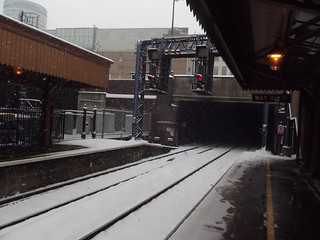
The tunnel was the first one to reopen back in 1987.
There used to be a late 1980s footbridge at this end, but it was removed when Moor Street was renovated Edwardian style (and they installed a new footbridge at the other end of the station).
The tunnel was the first one to reopen back in 1987.
There used to be a late 1980s footbridge at this end, but it was removed when Moor Street was renovated Edwardian style (and they installed a new footbridge at the other end of the station).
paul stacey
master brummie
Do I remember reading some where, that Hockley the biggest goods yard in Europe at one time???
paul
paul
Struggling to keep up here with all the info! It's fascinating how Snow Hill station has developed. Horsencarts photos of the tunnels, albeit sadly abandoned, show the skillful engineering which must have been needed to develop this line from the expanding and increasingly crowded City and make links with the outer suburbs. And what a contrast with Ell's Youtube clips showing the line as it is today, i.e. purely passenger focused. (Coincidentally I've just been watching Dan Snow's "Locomotion, locomotion" (BBC2) and he makes the point that passengers in the 1800s were really a secondary consideration. In the programme he reminds us that freight was the original intention; it was all about shifting goods and gaining profits. Hadn't really grasped this as I'd always thought about it from the passenger's viewpoint). So this line would seemingly have played a very important role in the 1800s in shifting all those 'toys' from the mass of Hockley workshops to places all over the country, as well as abroad. Viv.
And could someone please help explain Lyn's photos of Ickneild St Bridge please?! Did the trains go across that bridge ? Can't work it out. Great couple of photos Lyn. Viv
Lloyd
master brummie
And could someone please help explain Lyn's photos of Ickneild St Bridge in post #361 please?! Did the trains go across that bridge ? Can't work it out. Great couple of photos Lyn. Viv
That was part of the GWR Hockley Goods depot. For some time special low-height buses were used in the Inner Circle 8 route to fit under the bridges, but later the roadway was excavated out and normal ones would fit.
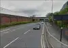
Here is that view today, with a much widened road and considerably less bridge! Pitsford Street is on the left in both old and new views.
https://goo.gl/maps/EqTp3
DavidGrain
master brummie
I don't have the facility to scan so I can't post the picture but I have just looked at Godfrey's reprint of the 1903 Winson Green and Hockley OS map and it shows 15 railway tracks across Icknield Street bridges. No wonder the bridges appeared to be a tunnel. Looking further out, the tracks ran under All Saints Street both sides of All Saints Church.
Picking up on Sue's post 356, New Street South Tunnel which she uses is "only" 254 yards whereas the North Tunnel out towards Smethwick is 751 yards. Unfortunately my railway maps are out of date so I do not know the lengths of the tunnels north and south of Snow Hill but the run in from Hockley to Snow Hill is mainly in deep cuttings with brick sides and only short lengths of tunnels.
The approach to Moor Street from the south is on a viaduct but all the other approaches to Birmingham stations are through tunnels and deep cuttings.
DavidGrain
master brummie
Sometime during the late 1980s when the Hockley Station was still a derelict site I wondered in through the gate in Pitsford Street where it is marked BM 422.7. I was able to get through onto the old station platforms and was shocked to see that the old subway steps were not filled in or covered over. There was rubble down the steps so you would not have been able to get into the subway. I am guessing that the building at the junction of Icknield Street and Park Road was the station entrance.
To our cycling friend Alan (Radiorails), you will have found many roads named Icknield Street or Ryknield Street on the course of the old Roman road north and south of Birmingham but unfortunately this one is misnamed as it was not on the course of the Roman road. This error is thought to have been a mistake by William Hutton in his book A History of Birmingham in 1782.
To our cycling friend Alan (Radiorails), you will have found many roads named Icknield Street or Ryknield Street on the course of the old Roman road north and south of Birmingham but unfortunately this one is misnamed as it was not on the course of the Roman road. This error is thought to have been a mistake by William Hutton in his book A History of Birmingham in 1782.
Thanks all. I'm surprised at the scale of all this. It was obviously built for shifting a lot of freight along this track. I notice on Mike's map that there's a road called 'Cattle Pens'. Surely they didn't also shunt cattle via Snow Hill? Although I suppose they might have done by herding them across town and then down to Digbeth perhaps? Viv.
Key Hill Brian
Proud Brummie
VIv,
Mikes map on 370 is of Hockley Goods Depot by Key Hill cemetery, not Snow Hill.
The "Subway" is Ickniled St - a single lane road than - now a dual carriageway. THe warehouses went across the bridhe, obscuring the view of trains from the Spring Hill Library side. The noise of the trucks being shunted could be heard very clearly in the evening over by Lucas's Gt King St as they bashed and banged!
On the extreme right of the map was a road entrance into the large goods shed, and there was a road tunnel that went under it to come up on the Cemetery side of the tracks. When the line was being removed in 1972 we drove through it to remove cabling for scrap.. Before they closed the tunnel entrances, it was possible to drive a lorry from Winson Green, right through Hockley, Snow Hill, Bordesley and come out on Golden Hillock Road at Small Heath!