• Welcome to this forum . We are a worldwide group with a common interest in Birmingham and its history. While here, please follow a few simple rules. We ask that you respect other members, thank those who have helped you and please keep your contributions on-topic with the thread.

    We do hope you enjoy your visit. BHF Admin Team
  • HI folks the server that hosts the site completely died including the Hdd's and backups.
    Luckily i create an offsite backup once a week! this has now been restored so we have lost a few days posts.
    im still fixing things at the moment so bear with me and im still working on all images 90% are fine the others im working on now
    we are now using a backup solution

Passages, Alleyways Gulletts and Snickets of Old Brum

I think the sign on the lamp could read 'Old ........ Wine & Spirit Merchants'
You are the closest so far LP with regards to the lantern. Likewise I do not know if they are awaiting something but it could be opening time. :D Well, it looks like the clock says 11 and the shadows do suggest the middle of the day.
 
Last edited:
I think it might have been an entrance to an alleyway to access the rear of buildings on Pinfold Street eg Christ Church National School rooms on Pinfold Street. Viv.
 
viv the picture i am looking at was the sign on the wall and some one said about the plaque on the wall
thats why i said you have to back to the eagle days because where you only see half the wording in white paint
and that is the left hand of the picture where the basket and cart is standing out side is the old eagle pub building in the early 1950
if not before
 
I notice the lantern isn't over the entrance it appears to be on the building below the entrance. 'PH' shows on old maps maybe it had a side entrance.
 
would it be possible for someone to do a kellys look up to determine things..also noticed the hill st bridge is not in shot so presume it must have been further down or maybe it had not yet been built..

lyn
 
where the lamp out side the building you are on about is an opening that when you look into it it goes down a slope
and directtly wher you see the men folk would have been postal sorting or postal office workers
and low on the ground nbehind them if you was there at the time of period you would see the little trucks trapping along and around the low grounds iis was not a walk way;;; and if this picture was not changhied from the forum with the rest of them we would have had the answer today as that was one of them ,
 
As stated in post 1224, the Samson and Lion was just about where the lantern is at no 51. The Old Rodney was a bit further up. the Golden Eagle must be the building on the near left (also with a lantern) next to the railway (it got larger after 1889 and took up several otherbuildings). Behind it is the entrance to Swallow St. Opposite the lantern which is being discussed is the wall overlooking the railway. the facy that the golden Eagle is lagfer than in th ephot means it was taken somewhat later than c1889.


map c 1889 showing top Hill st.jpg
 
Wow....Viv was right...The sign says Old Church Meeting Rooms.......allegedly......and it is the entrance to the rear of Christ Church School in Pinfold Street....hence the kids and office workers I suppose....the pub further down (not in shot, but on the maps) is said to be the Samson and Lion (info from another site)......a pic would be to die for.....? Another pic of an unknown to me Hill Street pub included.....Old Lamp on the right..? Too high up for the Samson and Lion?


Hill Street looking up 1910.jpg
 
Dennis, Not sure what your question is about. The red arrow on your map points to Lloyds Old Bank Limited in High Street although I have never seen Old Bank in the name of the bank before, only in the address. Your photos refer to Hill Street and I can only think that the lamp you show has something to do with the Post Office as I can't read it.

That's because I'm an old dweeb David..posted the wrong one...sigh.....will try to do better...promise! This is the one I should have posted.....17353461_10155021897911067_3298386380414809076_n.jpg
 
I know we have done CLEVE TERRACE on here before.....but this first shot of a school on there amazed me......never seen nor suspected it's existence....lurking in Cleve Terrace all those years ago...King Edwards Girl School....later KEGS for Girls Handsworth, my daughter's alma mater......she even parodied the Sports ethos like Ronald Searle's Molesworth....bless....
 

Attachments

  • 17353547_1574289995944819_674731444075144292_n.jpg
    17353547_1574289995944819_674731444075144292_n.jpg
    192.2 KB · Views: 59
  • 17353241_1574289762611509_5444193927559278496_n.jpg
    17353241_1574289762611509_5444193927559278496_n.jpg
    93.8 KB · Views: 58
  • Cleve Terrace 2.jpg
    Cleve Terrace 2.jpg
    177.8 KB · Views: 53
  • BellisSt.jpg
    BellisSt.jpg
    46.4 KB · Views: 56
  • Cleve Terrace 1.jpg
    Cleve Terrace 1.jpg
    90.8 KB · Views: 54
  • Nic's Kum on King Edwards.jpg
    Nic's Kum on King Edwards.jpg
    394.4 KB · Views: 55
  • OwenstCleveterrace1960.jpg
    OwenstCleveterrace1960.jpg
    22.8 KB · Views: 56
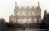
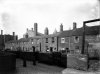
Just to add a little to the Hill Street conundrum....here's a bit about the National School in Pinfold Street....and a pic for reminders....


BIRMINGHAM NATIONAL SCHOOL, PINFOLD STREET. Established 1812. The lease of a site on the N.W. side of Pinfold St., between Lower Temple St. and Peck Lane (Birmingham Corporation, was obtained from the governors of the Grammar School by the trustees, of whom the Rector of St. Martin's was secretary. The rent of £15 was later remitted in exchange for permission to the governors to nominate 60 pupils. While the school was being built 2 rooms in Temple Row were rented and a master appointed. The temporary school opened Aug. 1812, and was visited and commended by Andrew Bell.

The ground floor of the new building (one room 80 ft. by 40 ft.) was opened as a Boys school in 1813, accomodating 500. The Girls school, over the Boys, was opened 1814 under a mistress especially trained in the National Society Central School

The sch. hours were 9–1, 2–4 in the winter, 8–12, 2–5 rest of year. The children attended church twice on Sundays. Pupils were nominated by subscribers. In 1814 it was said that 'no works of industry' were introduced, 'the children being taken into the manufactories at an early age'. In 1817 the G sch. was said to benefit from the assiduity of the lady visitors, while the B sch. apparently suffered from the irregularity of its visitors. The girls spent much time in 'plain work' which was sold; they excelled in religious knowledge. In 1818 there was a drop in attendance owing to the increased demand for children's labour, and to a decision not to admit children under 7 yrs. old. A Sunday sch. for girls was opened because the girls generally left the day sch. so young. Numbers continued to fall (n.o.b. 1824: 11 B, 69 G and 41 G in Sunday sch.) until 1826 when a new master and mistress were appointed. Fees 1835: 1d. (Hutton, Hist. Birm. (1835), 358). In 1837 the average time spent in the sch. was 10¼ months; n.o.b. 324, a.a. 150, with 3 teachers.There is no mention of the sch., except in maps, after a probable reference to it in 1845. It must have been pulled down c. 1850 in the building of New St. Station: in 1867 it was said that £500 had been 'allocated for sch. building, to each of four districts in Birmingham, being half the sum paid by the Railway for the lease of the ground, occupied by the old Central School near St. Martin's'. It was also said that probably no inspected sch. in the borough was in so low a state as the 'old central school at St. Martin's' used to be: this may have referred to St. Martin's, Inge St.
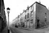


Pinfold St Christchurch School.jpg
 
Ladywell Passage 1913 (from the Shoothill site). This is the Ladywell Stone, once in Ladywell Passage, although I think the stone has probably disappeared. Viv.
image.jpeg
 
what a shame the stone is not there now viv...nice to have that photo as a reminder though

lyn
 
Thanks Pedro, agree it does sound wonderful, almost Roman! What exactly is a 'pleasure bath"? Viv.
 
Viv
I think it is what we would call a swimming bath, as opposed to one for cleansing or supposed medical uses
 
Just been replacing some images I posted to the first 30 pages of this thread, the ones that I replaced via Photobucket. That they so kindly withdrew their free image hosting services last year and left the forum in so much of a mess after it had just about recovered from the previous image incident. I have to say I didn't realise that I had used Photobucket's services quite so much.

I don't think this passage has been aired on here before, it's Cheyne Walk a passage that still runs between Greenfield Road and St Mary's Road in Harborne at the back of the High Street.


Harborne Cheyne Walk.jpg Cheyne Walk (2).jpg
 
Have we seen Chequers Walk on this thread? didn't notice it when I was looking the other day. Chequers Walk ran from Bath Row just down from Davenports brewery. You entered under a covered walkway under a shoe factory where the passage opened up to a mixture of houses and commercial premises the passage ended at Granville Street just short of the canal bridge.

Lee Bank  Chequers Walk Bath Row.jpg Lee Bank Chequers Walk Bath Row.JPG Lee Bank Chequers Walk.JPG chequers walk.jpg
 
Villiers Street Winson Green (1970s?)

30710548_10208669724380512_7582270818480024_n.jpg
 
good grief BB i do believe you have found a shot of the original gates and entrance to winson greet prison..need to check more but i will put money on it

lyn
 
Have we mentioned the cut-through which goes from Shortheath Road to Marsh Lane and then onto Summer Lane? I think, originally, this was an extension or part of Court Lane. I noticed that someone was parking at the entrance the other day.
 
Have we mentioned the cut-through which goes from Shortheath Road to Marsh Lane and then onto Summer Lane? I think, originally, this was an extension or part of Court Lane. I noticed that someone was parking at the entrance the other day.
Lady P
There used to be a cut through from Court Lane to Streetly Road via Jerry's Lane I think, I used to go that way when I went to my grandmothers in Queens Road off Slade Road. Do you know if that still exists?
Bob
 
I believe it is Bob although I haven't walked through it for years. It leads into Glendon Road and to the left was access to the rear of the properties in that road.
Oh, how I hated that hill in Jerry's Lane on the way home from Bridge Road and Knightwick Crescent.
 
Have we mentioned the cut-through which goes from Shortheath Road to Marsh Lane and then onto Summer Lane? I think, originally, this was an extension or part of Court Lane. I noticed that someone was parking at the entrance the other day.

Lady P there are now bollards at the Marsh Lane end so obviously it is pedestrian access only now.

marsh lane alley.JPG
 
Back
Top