No luck with Avenue Road or Headingley Road so far but will have a look when I've got more time
Bernie thanks
No luck with Avenue Road or Headingley Road so far but will have a look when I've got more time
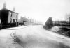
Bernie, #2971 is a good reminder of the Colonnade (is that how it's spelt?) and of that lovely fountain which used to change colour at night. There used to be a massive Christmas tree every year too.
Thanks for a lovely memory! How it's changed now that the Library is there.
rosie.
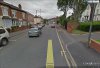
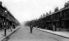
Bernie, I think it is Highfield Rd. A friend of mine used to live in that row of houses that curve around to the left. Also the end house is quite larger than the other terraces and you can see this in your picture and google maps, the road to the left is Glen Park Rd :emmersed:.Hi all I didn't really look at the picture very closely because it had a caption included but your right it's not Highfield Road as you say Rupert probably Nansen Road . I do remember the trams Rupert but the only one I can remember going on was to the Lickey's ' Hi Rosie and David IT is sad that they're gone and worse to see what's replaced them the Peace Gardens always seem full of down and outs drinking cider
I remember the houses being replaced with the new build, they were in quite a sorry state and were demolished."I went to Leigh Rd, too, around the same time and knew Highfield Road up as far as the top of the Rock anyway and I can't for the life of me remember that bend. Highfield was a straight road except for a bend over the railway bridge just before Washwood Heath and I don't think this is it. So pretty sure this is not Highfield Rd."
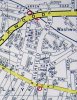
I think it may be, the attached pic is off google earth and it is looking towards Alum Rock Rd from just over the railway bridge. There is a new build on the left which is the corner of Glenpark Rd that replaces one of the houses on the original pic.
Terry
Yes it's good to acknowledge all the input:encouragement:Berniew fantastic old pics ,i look fwd to your input every night. Thank you robb128