-
Welcome to this forum . We are a worldwide group with a common interest in Birmingham and its history. While here, please follow a few simple rules. We ask that you respect other members, thank those who have helped you and please keep your contributions on-topic with the thread.
We do hope you enjoy your visit. BHF Admin Team -
HI folks the server that hosts the site completely died including the Hdd's and backups.
Luckily i create an offsite backup once a week! this has now been restored so we have lost a few days posts.
im still fixing things at the moment so bear with me and im still working on all images 90% are fine the others im working on now
we are now using a backup solution
You are using an out of date browser. It may not display this or other websites correctly.
You should upgrade or use an alternative browser.
You should upgrade or use an alternative browser.
Old street pics..
- Thread starter Astoness
- Start date
Dennis Williams
Gone but not forgotten
Dennis
As I said before, I think (but cannot be certain) that the 1851 house was demolished in the late 19th century
OK....it does look a little too well built to be from 1850s....but I think that's the plot?


Dennis Williams
Gone but not forgotten
Cheers mike...very perspicacious of you...whatever that means...?
Phil
Gone, but not forgotten.
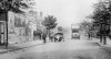
All the information that is required comes with this photo, it is pre 1914 and is taken on the Bristol Rd at Selly Oak and the bus marked Rednal is on its way the Licky Hills is just approaching Oak Tree Lane on the right of the photo. I think I would have recognised it as Selly Oak without the info, but I'm not sure I would have gotten where it was.
Attachments
Dennis Williams
Gone but not forgotten
Love that bus Phil! Now, another hopeful plea for help...this is a bit more local to me, but I thought I would ask the detectives whilst they are hot!.....one of the nice buildings in Yardley Village, where I live, is the Cottagers Institute, bang opposite the Church.....No.433 Church Road, the Cottagers Institute...it is dated on the gable 1882. It was set up by Ebenezer Hoskins of bedstead fame etc, once of the Grange, another old local historic building, to teach gardening and industrial skills to local people.....Now for a long time, there has been dispute in my mind, as in the Yardley Trust notes it states that this "Cottagers' plot was originally the site of the original Ring O'Bells pub...my favourite watering hole....now all gone....but I have never seen this mentioned in any old maps or in any books on the History of Yardley.....can anyone confirm or deny this argument with proof? Pretty Please...my neighbour and I have a fiver riding on it!!
 View attachment 96826


View attachment 96826mike jenks
master brummie
Hi
Just make out the Post office where Nan got her pension up to 1983. The Family lived at 533 Church Road.
All gone now Happy days in the Park Tennis and the Youth Club.
Mike Jenks.
Just make out the Post office where Nan got her pension up to 1983. The Family lived at 533 Church Road.
All gone now Happy days in the Park Tennis and the Youth Club.
Mike Jenks.
Phil
Gone, but not forgotten.
Dennis
I can't speak for what was on the site of the Cottagers Institute prior to that establishment, but I can tell you that the Old Ring of Bells was in more or less the same position as its replacement except for the fact that it might have encroached onto the land where The Grange stood nearer to Barrows Lane. I have no doubt that Mike will be delighted to furnish you with the maps.
I can't speak for what was on the site of the Cottagers Institute prior to that establishment, but I can tell you that the Old Ring of Bells was in more or less the same position as its replacement except for the fact that it might have encroached onto the land where The Grange stood nearer to Barrows Lane. I have no doubt that Mike will be delighted to furnish you with the maps.
Dennis Williams
Gone but not forgotten
Thanks for trying boys...I just had to check you two out before some time consuming research...ho. hum...will ket you know if anything turns up...
Dennis Williams
Gone but not forgotten
Another query....doing a bit on Sheldon and Elmdon and came across this pic showing a pub I've only vaguely heard of...The Cock Inn....on Coventry Road where the old Elmdon airport entrance is now..? Any one got a better picture of the pub Phil...and a map mike?

Phil
Gone, but not forgotten.
Dennis
This very same pub has been discussed on the forum a couple of times most recently here with photos and maps.
https://birminghamhistory.co.uk/forum/showthread.php?t=20019
This very same pub has been discussed on the forum a couple of times most recently here with photos and maps.
https://birminghamhistory.co.uk/forum/showthread.php?t=20019
Dennis Williams
Gone but not forgotten
Dennis
This very same pub has been discussed on the forum a couple of times most recently here with photos and maps.
https://birminghamhistory.co.uk/forum/showthread.php?t=20019
Cheers Phil....
NORTHFIELD
master brummie
The original Ring O Bells was opposite Yardley Church, the dark building. It was moved away from the church, because of protests about alcohol being served so close to the church. The same thing happened with The Ring O Bells, opposite St Giles Sheldon.
oldMohawk
gone but not forgotten
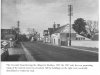
I remember when the Walsall Rd (A34) and the Aldridge Rd (A453) were single carriageway roads. I think the old pic below shows the Aldridge Rd between the Tame Bridge and Perry Barr, but here is something unusual in this 1960s pic namely the No 51 bus which appears to be 'off route'. The No 51 usually travelled from the Scott Arms along the Walsall Rd through Perry Barr to the city centre. The Midland Red originally ran the Nos 188 (Beeches Estate), 119 (Scott Arms), and 118 (Walsall) in the Great Barr district and when the River Tame flooded, these buses diverted along Church Lane on to the Aldridge Rd. Sometime around 1960, B.C.T. took over the 188 and 119 services numbering them 52 and 51. Flood prevention work eventually removed the need for diversions so there must be another reason for this number 51 travelling off route.

It could be the wrong number on the bus !
The old 1960's pic,
note the small window position
on the white house, also the chimney style.

Todays pic,
those windows etc are circled.
The house looks as if it is being demolished.

This pic shows the Walsall Rd and original single carriageway on the left, it looks slightly similar to the old pic. The 51 bus would have gone along here before diversion.note the small window position
on the white house, also the chimney style.
Todays pic,
those windows etc are circled.
The house looks as if it is being demolished.
Last edited:
Dennis Williams
Gone but not forgotten
The original Ring O Bells was opposite Yardley Church, the dark building. It was moved away from the church, because of protests about alcohol being served so close to the church. The same thing happened with The Ring O Bells, opposite St Giles Sheldon.
And your reference to that is?
brummie nick
master brummie
The garage shown on the left is now the KIA car showroom and the farm buildings are still standing.Another query....doing a bit on Sheldon and Elmdon and came across this pic showing a pub I've only vaguely heard of...The Cock Inn....on Coventry Road where the old Elmdon airport entrance is now..? Any one got a better picture of the pub Phil...and a map mike?
View attachment 96858
Nick
Dennis Williams
Gone but not forgotten
The garage shown on the left is now the KIA car showroom and the farm buildings are still standing.
Nick
Yes nick....just posted a whole heap of stuff about Elmdon on the dreaded FB site....here are a few pics from it...referring to your comment....thanks....
 View attachment 96868

Attachments
Last edited:
devonjim
master brummie
re knocking down "Cock Inn"View attachment 96867View attachment 96868
I would have thought it had more to do with the dualling of the A45 rather than the expansion of the airport, as they built the small hotel (Tri-Star) opposite Old Damson Lane after the road works. Not to mention the far more recent Travelodge.
The blind looks as though it's positioned in between destinations so it could have been on road test if it were based at a local garage.I remember when the Walsall Rd (A34) and the Aldridge Rd (A453) were single carriageway roads. I think the old pic below shows the Aldridge Rd between the Tame Bridge and Perry Barr, but here is something unusual in this 1960s pic namely the No 51 bus which appears to be 'off route'. The No 51 usually travelled from the Scott Arms along the Walsall Rd through Perry Barr to the city centre. The Midland Red originally ran the Nos 188 (Beeches Estate), 119 (Scott Arms), and 118 (Walsall) in the Great Barr district and when the River Tame flooded, these buses diverted along Church Lane on to the Aldridge Rd. Sometime around 1960, B.C.T. took over the 188 and 119 services numbering them 52 and 51. Flood prevention work eventually removed the need for diversions so there must be another reason for this number 51 travelling off route.
The old 1960's pic,
note the small window position
on the white house, also the chimney style.
View attachment 96862
Todays pic,
those windows etc are circled.
The house looks as if it is being demolished.
View attachment 96863
View attachment 96864
Dennis Williams
Gone but not forgotten
Another mystery property, currently looking very threatened by works going on around the area....it looks substantial enough for a name, lovely black and white tudor timbering etc......but no one seems to knows owt about it in the local history books, not name or history etc...it's just on your left as you come off the M42 at the Coventry Rd A45, right opposite the Airport Car Park....has anyone a clue what it is/was...or at least a map may tell us the name mike? Cheers folks....


Dennis
The building is marked as a lodge. It and the house it served are not on the map of c1888, but are on that of 1904, with the house called "The Hut". After WW2 the house seems to have been called Wyckhams Close, and that is still there according to Google maps, though the entrance is further down the A45. Below are maps for c1937 and c1961


The building is marked as a lodge. It and the house it served are not on the map of c1888, but are on that of 1904, with the house called "The Hut". After WW2 the house seems to have been called Wyckhams Close, and that is still there according to Google maps, though the entrance is further down the A45. Below are maps for c1937 and c1961
Dennis Williams
Gone but not forgotten
Dennis
The building is marked as a lodge. It and the house it served are not on the map of c1888, but are on that of 1904, with the house called "The Hut". After WW2 the house seems to have been called Wyckhams Close, and that is still there according to Google maps, though the entrance is further down the A45. Below are maps for c1937 and c1961
You absolute Beauty mike!!! first in class....eternal thanks..!
mike jenks
master brummie
Hi
Yep just a punt.
Wyckham Blackwell.
Close by 5 Station Road Hampton Arden.
Huge Timber Merchants all over the place
Established 1885.
Seems to me to be a business man place not a farmer?
Who knows best I can do
Mike jenks.
Yep just a punt.
Wyckham Blackwell.
Close by 5 Station Road Hampton Arden.
Huge Timber Merchants all over the place
Established 1885.
Seems to me to be a business man place not a farmer?
Who knows best I can do
Mike jenks.
Dennis Williams
Gone but not forgotten
Hi
Yep just a punt.
Wyckham Blackwell.
Close by 5 Station Road Hampton Arden.
Huge Timber Merchants all over the place
Established 1885.
Seems to me to be a business man place not a farmer?
Who knows best I can do
Mike jenks.
Wow...sounds cool mike....fabulous sleuthing as per!
mike jenks
master brummie
Hi
Check google Bickenhill castles farm looks like the photo
Mike jenks
Check google Bickenhill castles farm looks like the photo
Mike jenks
Dennis Williams
Gone but not forgotten
Hi
Check google Bickenhill castles farm looks like the photo
Mike jenks
Not as much as these though mike...from the Flikr archives....actually captioned Wykham Close...completely derelict place....dated 2011.....

 View attachment 96888View attachment 96888
.jpg")
mike jenks
master brummie
Hi
Yep getting close I think.
Need to position photos with the farm.
Mike jenks
Yep getting close I think.
Need to position photos with the farm.
Mike jenks
mike jenks
master brummie
Hi
Not castle hills still on wyckams
Mike jenks
Not castle hills still on wyckams
Mike jenks