47VentnorRd
Brummie babby
I know that between 1901 and 1921, George, Joseph and Thomas Evans moved out of 47 Ventnor Road and I know they lived nearby after marriage. It's possible at least one of them died in WWI.
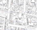
These photos are terrific - the first images I have of the area my Dad grew up in. The very bottom left corner of the top photo shows the beginning of Ventnor Rd, the east-facing side. Is it possible there are any other aerial photos that would show the area below the view of the top photo?Farm St school and St Saviour Church in this aerial view looking west over Hockley dated 1950. Bridge St West runs diagonally from bottom left and Farm St from bottom changing direction where Villa St crosses it.
View attachment 157112
A aerial view looking north dated 1948 shows the school and church from another direction.
View attachment 157111
images from 'britainfromabove'
Here are three views of Ventnor Rd dated 1950 but the aircraft was not in the best position for viewing that particular road. I haven't marked it because you know where it is ...These photos are terrific - the first images I have of the area my Dad grew up in. The very bottom left corner of the top photo shows the beginning of Ventnor Rd, the east-facing side. Is it possible there are any other aerial photos that would show the area below the view of the top photo?
")


Not Thomas or George, appear to have died in 53 and 60 respectively.
And Joseph seems to be still alive in 1921 living in Burbury St. Can't be certain, unlike the other 2 he has no middle name.
These are awesome - thank you so much! I tried searching 'britainfromabove' using their map and with various key words but nothing came up...what's your trick? ;-)Here are three views of Ventnor Rd dated 1950 but the aircraft was not in the best position for viewing that particular road. I haven't marked it because you know where it is ...
Pic 1 Ventnor Rd and gardens back on to the school.
View attachment 172830
Pic 2 Ventnor Rd from the southeast but only partial.
View attachment 172831
Pic 3 Ventnor Rd with gardens backing on to the school,
View attachment 172832
all images from 'britainfromabove
that comes as no surprise to me jan...its a very old pub and as far as i have seen over the last couple of years it has been totally gutted inside...I can't find anything on the planning site
do not recognise the old pub now...photos taken yesterday...plenty of work going on inside which is totally gutted


Is it going to reopen as the 'Queens Head' or put to another use ? The top of the archway and the four windows are recognisable although the latter are smaller. Used to live in the parallel Bridge St West way up the other end right next door to St Saviours church. Left in 1954 when the family moved to Northfield.do not recognise the old pub now...photos taken yesterday...plenty of work going on inside which is totally gutted
lyn
View attachment 177797View attachment 177798View attachment 177799
Ah well, there goes another bit of our local history. The two stone pillars at the entrance to Burbury St Park and the park keeper's house still exist from when I played there in the early fifties. I think they're original structures, unless of course they've been rebuilt !very doubtful it will remain a pub trevor...at one time i think planning permission was applied for turning into apartments...time will tell
lyn
It's court No. 57 Lyn.i wonder if anyone can identify the court name/number above the entry and post a map please..also looking at all the adverts around the shop does anyone know what football oats were..cant quite make out the rest of the words on the advert
lyn
Same for me - I remember Farm St, Wheeler St, Dr Carolan's surgery etc., to this day even though I was only 5 when we left to move to Unett St.thanks mike thats sorted that one out...looking again at that photo i find it strange to believe as a teenager i walked past many times without giving the shops or houses a second thought...guess a lot of us did at that age..
lyn