• Welcome to this forum . We are a worldwide group with a common interest in Birmingham and its history. While here, please follow a few simple rules. We ask that you respect other members, thank those who have helped you and please keep your contributions on-topic with the thread.

    We do hope you enjoy your visit. BHF Admin Team

Potter Street, Aston, C1900

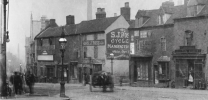
This photo of the junction of Steelhouse Lane and Lancaster Street shows the end of Potter Street in the background. The shop on the corner of Lancaster Street and Potter Street is S J Rose Cycles, which has replaced the Old Green Man PH. It's dated as c1900.

View attachment 207583
Another photo to take your breath away - superb detail on zoom in:-
1755672139145.png
1755672165113.png
 
Great image and so atmospheric.
Distinguishing feature are: 5 x terraced houses, entry to court at the rear, path/road on the right of the houses and signposted road/entrance on the left-hand side of them.
No houses on the 1892-1914 map fit this image but there is a possibility on the 1839 map which unfortunately is not greatly detailed.
Yes, I think you're probably right brummy-lad.
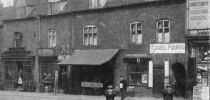
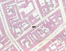
The photo in Post #26 shows a row of 6 terraced houses with a gap at either end, and an entry between the second and third houses from the right. That configuration is shown in this 1855 map of Potter Street, with the picture angle indicated by the black arrow.
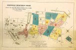
This was in the area affected by the Corporation Street development. Presumably these houses were demolished before the 1886 map (Post #14) was drawn, along with the Balloon Street area behind it.
Therefore the old houses would have been in the vacant area shown on the left of the photo in Post #14 .... dated 1905.

1855 Potter Street.jpg

1879 Birmingham Corporation Street Development 1.jpg
 
Yes, I think you're probably right brummy-lad.
The photo in Post #26 shows a row of 6 terraced houses with a gap at either end, and an entry between the second and third houses from the right. That configuration is shown in this 1855 map of Potter Street, with the picture angle indicated by the black arrow.
This was in the area affected by the Corporation Street development. Presumably these houses were demolished before the 1886 map (Post #14) was drawn, along with the Balloon Street area behind it.
Therefore the old houses would have been in the vacant area shown on the left of the photo in Post #14 .... dated 1905.

View attachment 207609

View attachment 207611
Geoff that's a brilliant street map of Potter Street, I searched for ages late last night for a map like that, would you mind telling me where you found it.

EDIT: Just found it, adding the date of 1855 brought it up on google.
 
Last edited:
Back
Top