So is this what Spring Lane is named after?That spring still flows, right behind my garden before crossing Holly Lane!
-
Welcome to this forum . We are a worldwide group with a common interest in Birmingham and its history. While here, please follow a few simple rules. We ask that you respect other members, thank those who have helped you and please keep your contributions on-topic with the thread.
We do hope you enjoy your visit. BHF Admin Team
You are using an out of date browser. It may not display this or other websites correctly.
You should upgrade or use an alternative browser.
You should upgrade or use an alternative browser.
Erdington
- Thread starter Alberta
- Start date
Richard Loud
proper brummie kid
Sunday Trading started around 1986 and Wilton Market opened in 1970 so the photo above was taken around 1966 as you can see the Village Green in the distanceThe number plate on the Vauxhall fixes the earliest date, the suffix 'A' was used Jan '63 to Dec '63. The shops look closed so it was probably on a Sunday. When did 'Sunday trading' start? A Morris 1100 and possibly an Hillman Imp parked might offer date clues. A man in a smart belted Gaberdine mac holding his daughter's hand ... I think that might have gone out of fashion before the mid '70s. It has a mid to late '60s look to me.
Thank you for your reply Richard. Oldmohawk has sadly passed away, but your comments are a welcome addition to this thread and for the benefit of other readers.
Richard Loud
proper brummie kid
We lived at 24 Alleyne Road and I fell off my bike on the corner where the road sign is as well when I was about seven around 1969Good story Johnny.
Good old Alleyne road, I've whizzed down that road a few times on me 3 wheeler and goies.
Whoops it's happened again! A lorry collided on Summer Road in Erdington, before 11am on Friday (Jan 3). The road was shut in both directions by police while emergency teams worked to remove the lorry. Train services from New Street Station to Lichfield Station were disrupted by the incident:oops! The lorry stuck the bridge in Summer Road, Erdington, carrying rail services on the Cross-City Line. 2018
View attachment 175264


Key Hill Brian
Proud Brummie
Happens too often nowadays, how about taking the license of the driver who does not know how high is load is, or remove the operators license or a hefty fine to the Company for not training their drivers in height measurement?
One day all those delayed by such stupidity will follow the increasing USA practise and start suing for every delay and inconvenience caused by such stupidity. That would make idiots drivers almost uninsurable!
One day all those delayed by such stupidity will follow the increasing USA practise and start suing for every delay and inconvenience caused by such stupidity. That would make idiots drivers almost uninsurable!
Yet again, twice in the same day at exactly the same spot and three times in a week! (see BBC News link below)
Are these lorry drivers all following their satnavs, without having any regard to the height of their vehicle and the approaching bridge? Surely word is getting around amongst haulage companies, that this is a short cut that has consequences?


Link: https://www.bbc.co.uk/news/articles/c74x214zj89o
Are these lorry drivers all following their satnavs, without having any regard to the height of their vehicle and the approaching bridge? Surely word is getting around amongst haulage companies, that this is a short cut that has consequences?
Link: https://www.bbc.co.uk/news/articles/c74x214zj89o
Moor End Lad
master brummie
I remember how my Mum used to drag me around Erdington shopping during the 1950s before supermarkets existed. I recall a grocers at the upper end of the High Street called either the Maypole or Perks where she would often buy a quarter of broken biscuits. I also remember my Mum coming home from the village and saying that a bull had jumped out through the plate glass window of Thompsons butchers and run amok in the High Street! Does anyone recall that incident?
Moor End Lad
master brummie
I can date that photo for you. The brick extension to the Roebuck was built in 1962, and everything you see was demolished 2 years later in 1964.A few years ago I posted a couple of photos of the National School which stood close to
Erdington Parish Church on the High Street and also a photo of the second edition of
the Roebuck Pub which was next to the National School. These photos were sent to me by
Erdington Library many years ago after I asked them in particular for a photo of the National School
as no one seemed to have a photo of the place. I remember both of these buildings very well. I will post the black and white photo of the School in the next post.
Thanks for your kind offer of information. Unfortunately, member Jennyann passed away a while back, hence her avatar is showing “gone but not forgotten”I can date that photo for you. The brick extension to the Roebuck was built in 1962, and everything you see was demolished 2 years later in 1964.
Moor End Lad
master brummie
Yes. The High Street travels along high ground that dips down sharply towards Spring Lane. Rainfall would take the same path and rose as a spring now concealed under the gardens of Fern Road. It was piped under the houses to the other side of the lane, where it emerged in the field behind Briar Cottage known locally as the 'Scout Field' on account of it hosting the scout hut for the 105th Birmingham scout troop (later burnt down by vandals). Crossing the field it was known as Holly Brook and was conduited at the outbreak of WWII to cross under Spring Lane AAA site, finally emerging on the far side of Holly Lane. The Scout Field was later developed as the Blossom Hill estate. The scouts used to host a fireworks night like no other; there would be a huge bonfire and a basic display, but visitors were allowed to bring and set off their own fireworks wherever they wanted! Health & Safety would have a fit these days, but then it was just incredible fun with jumping jacks and bangers going off all around.So is this what Spring Lane is named after?
For completeness, access to the Scout Field was down a drive off Spring Lane between two houses opposite Fern Road. At the end was a farm gate in line with the far ends of those properties' gardens. After Blossom Hill was developed the drive appears to have been subsumed into one of those properties mentioned, and no trace remains.
Last edited:
Moor End Lad
master brummie
Sorry to hear about Jenny Ann. I wish that I'd found this thread earlier.Thanks for your kind offer of information. Unfortunately, member Jennyann passed away a while back, hence her avatar is showing “gone but not forgotten”
Moor End Lad
master brummie
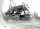
I'm going to come out all guns firing here, as this is my patch. These are two conjoined cottages known as 'Shipley Cottages', which stood in Moor End Lane from around 1600 until 1936, whereupon they were bulldozed in favour of the Berkswell Road development. They stood opposite to what became Moor End Lane School, and my family home was built on the site in 1937. Here is a larger photo, which shows the Moor End Lane context:
Attachments
Moor End Lad
master brummie
When I was young a Bakers Removals van was routinely parked in Mason Road opposite the swimming baths. Maybe one of the drivers lived there.Well spotted Curly ! I suppose as good a place as any to show off their furniture vans ...")
Moor End Lad
master brummie
Isn't that a very desirable Vauxhall VX490? Erdington still looked very respectable in the 1960s, but note the empty bottle having been dumped in the right foreground.Erdington High Street in the early 1960s when the parking was easy as demonstrated by the owner of that Vauxhall Victor.
View attachment 120419
Moor End Lad
master brummie
That restaurant was called the 'Lotus House'. Back on the library side was Wilton Road, which hosted 'Colmore Depot' and a music shop. I recall that the garage extended back to a showroom that opened on to the High Street where the old 'Picture House' had been (possibly the same building knocked through). I went with my father there to have a look at an Austin 1100 when it was introduced c1970. What stood in place of 'Blockbusters' I also cannot recall.Morturn, they were on the opposite side of the road weren't they? Same side as the police station. That Chinese Restaurant was the first one I ever went to. Was it called the China House? I don't remember the chemist or the optician though. I think my problem with this end of Erdington was that I very rarely went this way. If we went 'up the village' from Court Lane it was usually on the little red bus or if we walked we would go through the two gulleys coming out in Summer Road and then cut through to Sutton New Road and up to the shops. I probably only passed that way going to the swimming baths.
Opposite the police station was the 'Erdington Coffin Manufacturing Company', which had a huge air cleaner outside that looked like a tornado and used to scare me!
The modern building opposite the library (and next to the Swan) was a big carpet shop - Allied Carpets - in the 1970s. Used to cut through alongside the shop there to cross Sutton New Road to head down Wilton Road, then Osborne Road to Station Road to the #28 bus on Gravelly Lane. I think the building was new in the 1970s.
Last edited:
If you lived opposite the school would you remeber the Newton family?I'm going to come out all guns firing here, as this is my patch. These are two conjoined cottages known as 'Shipley Cottages', which stood in Moor End Lane from around 1600 until 1936, whereupon they were bulldozed in favour of the Berkswell Road development. They stood opposite to what became Moor End Lane School, and my family home was built on the site in 1937. Here is a larger photo, which shows the Moor End Lane context:
Pedrocut
Master Barmmie
I'm going to come out all guns firing here, as this is my patch. These are two conjoined cottages known as 'Shipley Cottages', which stood in Moor End Lane from around 1600 until 1936, whereupon they were bulldozed in favour of the Berkswell Road development. They stood opposite to what became Moor End Lane School, and my family home was built on the site in 1937. Here is a larger photo, which shows the Moor End Lane context:
How did you trace the cottages as far back as 1600 ?
Moor End Lad
master brummie
Pedro you've asked an essay question, which I will gladly answer in due course on the 'Moor End Lane' thread rather than the 'High Street' thread, because there is a wealth of history attaching to that particular area. In very simple terms you only have to look at it to date it, but its actual structure goes back to mediaeval times and was probably moved from elsewhere c1600.How did you trace the cottages as far back as 1600 ?
Edit: I've now located a lot of related info that we both contributed to some years ago on this thread: https://birminghamhistory.co.uk/forum/threads/moor-end-green-house.48947/page-3
Last edited:
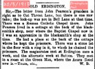
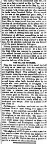
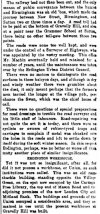
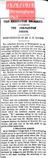
Interesting Erdington history and a debate about the location of the 'lock up'. Was it Bell Lane (Orphanage Road), or behind the blacksmiths or at the house adjoining the Queens Head Hotel? Reservoir Road was once Cut Throat Lane - it takes little imagination as to how the name came about.
Source: British Newspaper Archive
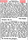
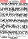
Source: British Newspaper Archive
Attachments
-
 Screenshot_20250114_184819_Chrome.jpg157.2 KB · Views: 7
 -
 Screenshot_20250114_185109_Chrome.jpg310.9 KB · Views: 5
 -
 Screenshot_20250114_185413_Chrome.jpg446.7 KB · Views: 5
 -
 Screenshot_20250114_185650_Chrome.jpg280.5 KB · Views: 4
 -
 Screenshot_20250114_185630_Chrome.jpg271 KB · Views: 7
 -
 Screenshot_20250114_185622_Chrome.jpg410.5 KB · Views: 7
Yet again a lorry has struck the low railway bridge on Summer Road, Erdington. Cross City line trains were again suspended on 30th April. See the photograph below, my previous post #693 and the link to the Birmingham Live report of the latest crash:

Link: https://www.birminghammail.co.uk/news/midlands-news/birmingham-railway-bridge-struck-again-31542209
Link: https://www.birminghammail.co.uk/news/midlands-news/birmingham-railway-bridge-struck-again-31542209
Cliff gebhard
proper brummie kid
Remember the village as a kids went Osborne rd school as a kid in the 50s. The village was great then!Erdington High Street was my complete "universe" growing up. I started attending St. Barnabas Children's Church services on Sunday mornings when I was eight. Before that I attended the Baptist chapel in George Road and was entered on the Cradle Role when I was born. My Mother thought the Baptists were too strict and so we, my youngest brother and I, went to Erdington Parish, as we knew it. We could have gone to St.Mark's at Stockland Green where I was christened but the Minister at the time was quite strange.
That photo, which I imagine was taken in the early l950's, was typical of the High Street on Saturday, packed tight. As Alberta said, "Going to the Village" was the thing to do on Saturdays. Sundays, the street was totally empty. The High Street was also known as the local "Monkey Run" for quite a few decades. My father talked about walking over to Erdington Village from the Witton area with his brother and often mentioned what a lovely village Erdington was. This would have been in the early l920's.
I believe Littlewoods is still there, at least it was in 2004. My friend and I used to look under the sweet counter on Saturdays to find the wrapped sweets that had been dropped by the assistants.I can remember the old National School that was across the road from Littlewoods, long gone now, a small precinct now stands on the site.
I also remember Hazel's the Undertakers, which is still there and also Mr. Hazel, who used to march down the High Street wearing a fly-away collar and as Alberta says he was very tall and thin. He had an assistant who dressed in the same style. Mr. Snape was his name.
I ended up going to St. Barnabas three times on some Sundays, well, to the Church House, which you can just see in the photograph opposite the Church, on Sunday afternoons to Sunday School and when I was in my teens I went to the evening service. Many of my friends from school used to go as well so it was my out of school social life in a way. My parents were very strict about where I went and what I did in that respect. I attended Discoverer's on Thursday nights, it was a mixed group and I learned how to dance the Gay Gordans and the Valeta! Lovely memories of dancing in the Carlton Ballroom above the furniture shop that eventually became the famous "Mother's" Rock Club. Things were great until the Teds arrived and the fights started! Good entertainment. :knuppel2:
I remember going to the Ladies in the Acorn pub on the corner of Church Lane and the High Street, visible in the photo but never going into the pub itself. Went to The Roebuck pub later on. The Palace Cinema, The Palace Ballroom and the Erdington Picture House were well attended. I also remember when the El Toro Coffee House opened up in the late l950's. It was a great hang out and people used to line up to go in. Espresso Coffee was all the rage then for teenagers. They had a juke box on the ground floor. I met my first serious boyfriend in there. :smitten:
The shoe shops in the High Street got a lot of my wages years ago and I remember my Mother taking me and my brother to Dick's Coffee House. Upstairs they had a tea room and downstairs they sold coffee and coffee beans. The smell was heavenly. We were only allowed to have one cream cake even though a cake tier was brought to the table with several cakes on it. :-\
The High Street is much changed now, of course. The trees in front of the church are still there.
The wall was lowered many years ago so that the churchyard could be seen. The old Vicarage was pulled down and a new one built. So many memories in that High Street for me.


My recollections of that are it was built into the low wall that surrounded the pristinely manicured village green that no one was allowed to walk on. I recall it had some mention of queen Victoria, perhaps a jubilee.This is a street view at Erdington village green, opposite the Library. Does any one know what it represents ?
View attachment 201757
