-
Welcome to this forum . We are a worldwide group with a common interest in Birmingham and its history. While here, please follow a few simple rules. We ask that you respect other members, thank those who have helped you and please keep your contributions on-topic with the thread.
We do hope you enjoy your visit. BHF Admin Team
You are using an out of date browser. It may not display this or other websites correctly.
You should upgrade or use an alternative browser.
You should upgrade or use an alternative browser.
Windermere Rd Park/ground Saved
- Thread starter Morturn
- Start date
pjmburns
master brummie
Thanks Viv.The fruit looks very healthy Janice.
We removed quite a number of apples yesterday to allow the rest to grow larger. Those removed will be used - mainly in cooking as they won't be fully ripe yet.
And sell 'em Lyn, putting money back into the park !
pjmburns
master brummie
Just so you don't think it is all sowing seeds and looking at the pretty results.
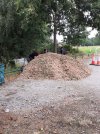
This was the scene yesterday morning at 10.15.
A wagon arrived and dumped a load of wood chip

This was the result
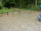
Two hours of hard work later the car park looked like this
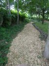
End result is paths now more visible and easier to walk on
This was the scene yesterday morning at 10.15.
A wagon arrived and dumped a load of wood chip

This was the result

Two hours of hard work later the car park looked like this

End result is paths now more visible and easier to walk on

astonishing jan...how you and your co helpers managed to get all of that bark from the car park to the path and spread it in a couple of hours i will never know...well done to all i have seen the video of it being off loaded and there was tonnes of it
lyn
lyn
pjmburns
master brummie
Most Birmingham parks seem to have "friends groups" who organise activities or generally help maintain the park.
Until recently we had the support of a ranger who came and helped and gave us advice but because of cuts (Birmingham short of cash) we no longer have a ranger assigned to our park.
Not sure if I have said before but we also have a weekly tai chi/ qi gong session. This was free but we are now making a small donation each week to keep the group going.
A local football team trains on the field and plays their home matches there - the coach is actually running sessions during the holidays - as he says it keeps the lads off the streets.
A regular haunt of dog walkers and joggers alike. It also provides the main car park for visitors to Moseley Bog.
So it is a well used amenity.
shame you have lost your ranger jan and now have to pay to continue your tai chi sessions but as you say it is a result of bcc being cash strapped...thoughtful also of the footie manager to keep the training up during the holidays...if only everyone pulled together like this (and i am sure a lot do) then all would be good...keep up the good work but dont over do things..look forward to your undate photos
lyn
lyn
Apparently there as a windmill on the fields years back seen in David Cox's notebook.View attachment 122902
Some history about Richard Grevis' windmill that Morturn mentioned in the above post earlier on this thread. It was linked to Moseley Hall. And there was possibly an Iron Age enclosure somewhere on the site (later ploughed out) From the Bill Dargues site.
There seems to have been visible evidence of an earthwork on what is now Wake Green playing field between Yardley Wood Road and Windermere Road. Possibly an Iron Age enclosure, it survived until the 1820s when it was ploughed out. There was a local legend that King Alfred made his headquarters here before locally defeating the Vikings. While this is possible, it is more likely an imaginative antiquarian invention.

This may be David Cox's Wake Green windmill
Also on the playing fields on a site to the rear of Adrian Croft, Wake Green Windmill was recorded in 1664 as belonging to Richard Grevis of Moseley Hall. It is known to have been leased in 1766 by John Allen from John Taylor of Moseley Hall. It had been demolished by 1834. This windmill is one of the few Birmingham windmills whose appearance is known: a sketch exists drawn by Birmingham water-colourist, David Cox in 1819.
The stream is most likely the one which feeds Sarehole Mill (water driven). It goes through Moseley Bog to Sarehole.
The mill on the fields is believed to have been a "post mill". That is the wooden top part could be turned so it could best use the wind.
interesting jan thanks
lyn
Richard Dye
master brummie
That is great story about King Arthur! I really enjoy that history, too bad it was ploughed out.Some history about Richard Grevis' windmill that Morturn mentioned in the above post earlier on this thread. It was linked to Moseley Hall. And there was possibly an Iron Age enclosure somewhere on the site (later ploughed out) From the Bill Dargues site.
There seems to have been visible evidence of an earthwork on what is now Wake Green playing field between Yardley Wood Road and Windermere Road. Possibly an Iron Age enclosure, it survived until the 1820s when it was ploughed out. There was a local legend that King Alfred made his headquarters here before locally defeating the Vikings. While this is possible, it is more likely an imaginative antiquarian invention.
This may be David Cox's Wake Green windmill
Also on the playing fields on a site to the rear of Adrian Croft, Wake Green Windmill was recorded in 1664 as belonging to Richard Grevis of Moseley Hall. It is known to have been leased in 1766 by John Allen from John Taylor of Moseley Hall. It had been demolished by 1834. This windmill is one of the few Birmingham windmills whose appearance is known: a sketch exists drawn by Birmingham water-colourist, David Cox in 1819.
pjmburns
master brummie
Following on from all the chat about history of the Fields.
Today a small group of us attended a history walk/talk round the fields given by Dr Mike Hodder (former city archaeologist).
He told us about the ridge and furrow markings which can be seen - dating from when the fields were common land.
How the make up of the boundary hedge can help determine it's age.
We walked down into a large dip (which I was once told was a bomb crater) but is the remains of a pit dug to remove, and use, the top layer sand, the gravel from lower down and finally the underlying clay.
For me, however, the really fascinating bit was where he thought the windmill, referrrd to in earlier posts, had been sited. Not where I expected. Just inside what is now the boundary hedge to the top level of Moseley Bog. Where old maps show an area known as Windmill Close. I will post a link to a map showing this when I put my laptop on.
If I have written anything wrong then fellow Forum members who walked today, Morturn and Superdad3, will hopefully correct me. Nice to meet up with them.
Thanks to Mike for talking to us.
Last edited:
I think your very much spot on with your summary there Janice, perfect, many thanks.
I had already done a drone survey of the field earlier in the year that can highlight detail of the field marking. It was nice of Mike Hodder to give some explanations and also look at some previous suggestions that it may be a hill fort, but the evidence did not really support this.
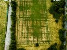 The first image shows a number of previous football and possibly Rugby and cricket pitches marked out. The changes in the grass are possibly cause by the substance (fleet with is caulk based) to make the pitches.
I had already done a drone survey of the field earlier in the year that can highlight detail of the field marking. It was nice of Mike Hodder to give some explanations and also look at some previous suggestions that it may be a hill fort, but the evidence did not really support this.
 The first image shows a number of previous football and possibly Rugby and cricket pitches marked out. The changes in the grass are possibly cause by the substance (fleet with is caulk based) to make the pitches.
Mike talked about the boundary adjacent to the cricket club and how it was hedge and a ditch. He also said it have been moved, possibly when the large houses were constructed. Mike also talked about how field marking are more visible at different time of year and lighting conditions.
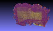
With a detailed drone photogrammetry survey, we can apply artificial lighting and shading to bring out hidden detail.
This image shows the old boundary and interestingly the clay pits are much older than we thought.
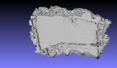
With a detailed drone photogrammetry survey, we can apply artificial lighting and shading to bring out hidden detail.
This image shows the old boundary and interestingly the clay pits are much older than we thought.

Richard Dye
master brummie
Mort, what kind of drone/camera has the photogrammetry? Thank you!Mike talked about the boundary adjacent to the cricket club and how it was hedge and a ditch. He also said it have been moved, possibly when the large houses were constructed. Mike also talked about how field marking are more visible at different time of year and lighting conditions.
With a detailed drone photogrammetry survey, we can apply artificial lighting and shading to bring out hidden detail.
This image shows the old boundary and interestingly the clay pits are much older than we thought.
View attachment 196722
Mike also discussed agricultural use of the land and how it was once common land. Interestingly farming techniques of cultivating for crops in strips still continued into the early nineteenth century.
The images also show a likelihood of WWII allotment use. Janice did a super piece of research and thinks she can identify the allotments were done by a local school.
Talking to Mike, he feels that this site still has a lot to offer in terms of research. I certainly feel it fortunate that the field been retained as a recreational site and been protected from the heavy duty farm machinery which today would have ploughed out all of the field marks.

Hi RichardMort, what kind of drone/camera has the photogrammetry? Thank you!
I use a DJI Mini 3 Pro now. It weight is less than 250g, so the Civil Aviation Authority approve it use on site like this. I am also registered as a drone pilot with them.
The drone has a 12 megapixel camera that can give a ground resolution of 1.8 cm per pixel so, it is very accurate for surveying work. You can put GPS ground control points in too, but I was more interested in revealing hidden features.
I use a programme call Agisoft Metashape to process the images into a photogrammetry 3D model.
Reality Capture is also a super photogrammetry programme too. Photogrammetry is a super tool for archelogy, quick, easy, none damaging and it will highlight areas of potential further interest.
Absolutely fascinating. Thanks Janice and Mort.
This is a great demonstration of the opportunity to uncover lots of previously undetected/lost historical features. I think it's incredibly exciting. So much to discover out there.
This is a great demonstration of the opportunity to uncover lots of previously undetected/lost historical features. I think it's incredibly exciting. So much to discover out there.
Richard Dye
master brummie
Thank you very much! We have DJI’s here so I will take a look. I went to a seminar where Robert Ballard of Titanic fame was the presenter (super interesting) who had a colleague who specialized in aerial photography as well as the use of ground penetrating radar and laser application's, attended his seminar. Unfortunately my mobility is restricted, however I should be good to go in another few weeks. Your information on the type of drone (so many out there) as well as cameras etc will give me great guidance. Thank you!Hi Richard
I use a DJI Mini 3 Pro now. It weight is less than 250g, so the Civil Aviation Authority approve it use on site like this. I am also registered as a drone pilot with them.
The drone has a 12 megapixel camera that can give a ground resolution of 1.8 cm per pixel so, it is very accurate for surveying work. You can put GPS ground control points in too, but I was more interested in revealing hidden features.
I use a programme call Agisoft Metashape to process the images into a photogrammetry 3D model.
Reality Capture is also a super photogrammetry programme too. Photogrammetry is a super tool for archelogy, quick, easy, none damaging and it will highlight areas of potential further interest.
pjmburns
master brummie
Maps of the area can be fond hereFollowing on from all the chat about history of the Fields.
Today a small group of us attended a history walk/talk round the fields given by Dr Mike Hodder (former city archaeologist).
He told us about the ridge and furrow markings which can be seen - dating from when the fields were common land.
How the make up of the boundary hedge can help determine it's age.
We walked down into a large dip (which I was once told was a bomb crater) but is the remains of a pit dug to remove, and use, the top layer sand, the gravel from lower down and finally the underlying clay.
For me, however, the really fascinating bit was where he thought the windmill, referrrd to in earlier posts, had been sited. Not where I expected. Just inside what is now the boundary hedge to the top level of Moseley Bog. Where old maps show an area known as Windmill Close. I will post a link to a map showing this when I put my laptop on.
If I have written anything wrong then fellow Forum members who walked today, Morturn and Superdad3, will hopefully correct me. Nice to meet up with them.
Thanks to Mike for talking to us.

Moseley Bog: A Journey Through Time
Although we now know the area of woodland, wetland and meadows that lie between Yardley Wood Road, Windermere Road and Swanshurst Lane as Moseley Bog, this is actually a relatively recent name for …
 andyunderscore.com
The first map has a windmill marked and the second map shows the windmill no longer marked but Windmill Close is indicated.
Richard Dye
master brummie
Very interesting evolution!Maps of the area can be fond here

Moseley Bog: A Journey Through Time
Although we now know the area of woodland, wetland and meadows that lie between Yardley Wood Road, Windermere Road and Swanshurst Lane as Moseley Bog, this is actually a relatively recent name for …andyunderscore.com
The first map has a windmill marked and the second map shows the windmill no longer marked but Windmill Close is indicated.
Richard Dye
master brummie
Beautiful!I poped over Windermere Fields with The Pointer today to be greeted by both mist and frost
View attachment 197061View attachment 197062


