• Welcome to this forum . We are a worldwide group with a common interest in Birmingham and its history. While here, please follow a few simple rules. We ask that you respect other members, thank those who have helped you and please keep your contributions on-topic with the thread.

    We do hope you enjoy your visit. BHF Admin Team

Where is This? - No. 112

ChrisM

Super Moderator
Staff member
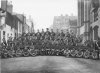
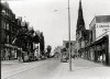
Another WW2 teaser. This is very probably, but not absolutely certainly, Birmingham. It is dated between 1942 and 1944.

The photo is ascribed to Taylors Press Service, 366 Soho Road, Handsworth, Birmingham 21. Which is why I think that the location could be somewhere in Birmingham.

The blokes, a number of whom are identified, are all Home Guard officers from units as far afield as Glasgow, Edinburgh, Shropshire and Leicestershire. So it's probably a course of some kind. But where? I know of just one HG School in Brum, in Bristol Street. The pupils had digs in the Blind Institute in Carpenter Road. There may have been other centres.

Any thoughts, please?

Chris
 

Attachments

  • HG-1HDWEB.jpg
    HG-1HDWEB.jpg
    98 KB · Views: 6
Last edited:
Chris,
Ot just might be St Martin's, taken in St Martin's Lane, with the tall building behind in Spiceal Street. But I thought the buildings in St Martin's Lane were a lot grander than those in the photo.
Peter
 
Thanks very much for those opinions, Peter and Derek. Judging by the general lack of response this looks to be an impossibly difficult one and, as Derek suggests, it might well be a Coventry location or that of another Midland town.

If we are talking about that part of central Birmingham, as Peter suggests, no doubt all the area has been swept away and it would take a pre-1960s memory to identify it. It has already been knocked about a bit: not just the bomb damage to the left but also a damaged roof in the middle distance to the right.

Over the weekend I'm hoping to receive a higher definition scan and I'll post a clearer image of the background if I can. But I think we might have to conclude that this isn't something which is ever going to be identified with absolute certainty. A pity, because I hoped that the buildings would be reasonably distinctive.

Chris
 
I think the buildings are the key the church on the right the building right rear and the building back left hand side just out of focus I would hazard a guess and say just off bristol st but then again?.. interesting photo
 
Thank you for further contributions.

I particularly like the suggestion of Bristol Street but, unfortunately, for no better reason than that is where I want it to be! As OtherHalf says, the church is the key. I have had a look at the list of Birmingham churches and noted those that have been demolished (as I assume this one has) but gave up when I got into double figures. For a couple of seconds I thought that we might have been looking at a church at the southern end of Bristol Street called, I think, St Luke's. That survives and appears on satellite views but it does not appear to be the building. Looking at a pre-war map of that area I note at least four churches and chapels, all within a few hundred yards of each other. The extent of the redevelopment and the disappearance of almost everything is staggering.

Otherwise the majority vew is that it is at a more central location (if of course it is Birmingham at all). Wherever it is the street is quiet enough to allow a large group of men to assemble and have their picture taken.

As a last throw I attach some magnified versions of the buildings on the photo. I suspect that there is a road running at right angles to the rear - one can pick out buildings perhaps on the other side of it. That could make the view we have of the imposing building at the back of the picture its rear view rather than its frontage. Or is there another street running off to the right between us and it?

Any final thoughts please? Thanks.

Chris
 

Attachments

  • Ashleycrop1web1000.jpg
    Ashleycrop1web1000.jpg
    71.2 KB · Views: 6
  • Ashleycrop2web1000.jpg
    Ashleycrop2web1000.jpg
    58.3 KB · Views: 6
  • Ashleycrop3web1000.jpg
    Ashleycrop3web1000.jpg
    34 KB · Views: 6
Last edited:
I think the location is too narrow to be Bristol St, even at this early date. May I make a suggestion. In my opinion it could be Ashley Street at the side of the Old Meeting Church Bristol St.

If you look at the photo of the church, there are similarities, and if you look at the photo of Bristol St the building opposite the church is of a similar design to that in the background of the original photo.

I am sorry that I do not have better photo's to demonstrate my point, The photo of the church is an early one, but the photo of Bristol St is much nearer the date of the original, but I think you have to agree there are similarities.

Phil
 

Attachments

  • Hollaway Head Bristol St The Old Meeting Church.jpg
    Hollaway Head Bristol St The Old Meeting Church.jpg
    114.5 KB · Views: 7
  • Horse Fair  Bristol St 1949.jpg
    Horse Fair Bristol St 1949.jpg
    79.7 KB · Views: 7
I think you are firm favourite for the Gold Star, Phil, with a Silver to OtherHalf for pointing us in the right direction: "just off Bristol Street"

I'll come back later in the day with reasons why I am so convinced but I've run out of time at the moment.

In the meantime, one or two follow-up questions (icing on the cake) if anyone could comment:
1. Why a mention of Hollaway Head in the church caption? Or does it denote the general area? (Excuse my ignorance).
2. All swept away in the 1960s, I assume?
3. I'm trying to link this location with unknown premises at 130 Bristol Street. Would any directory give an indication of where the church stood in relation to that address? It ISN'T the church itself, I assume?

What a noble structure it was.

Thanks to all for your patience and interest.

Chris
 
Last edited:
Chris
I think you're last statement may wrong and your question very relevent. Here is 1944 Kellys for Bristol st, east side:
126 Smart W. H. & Co. Ltd.
ham & bacon curers
128 Midland Magneto Co​
OLD MEETING CHCBCH​
here is Ashley st​
138 Proffitt & Westwood​
Ltd. corn fctrs
mike
 
I would say in my humble opinion that Phil is right, photo taken from Ashley Street.

Caption on photo is almost certainly wrong- Holloway Head didn't connect with Bristol St., it joined Horsefair at the junctions of Suffolk St. and John Bright St.
 
Don't get carried away with the caption on the photo, that may simply have been me renaming the file to sort it into some sort of local area. I later renamed most of the photo's in that area as the Horsefair, but its definitely the Old Meeting Church Bristol St. I never change the original caption just add a locality.

Phil
 
Thanks, everyone

Mike - from what you are saying, if I'm interpreting everything correctly, between nos. 128 and 138 there is nothing except a large site and then the entrance to Ashley St. - APART from mention of the church which presumably fills the gap in between and is therefore theoretically numbered 130/132/134/136 Bristol Street.

Have I got it right?

Chris

PS

Phil...
The two images you posted are potentially very useful. Would you permit me to use them, please - with due acknowledgement of course?
 
Last edited:
Chris
Yes That's it near enough. Churches never seemed to receive numbers, at least not in the directories, though there was usually a space in the numbering system to accomodate them. It doesn't necessarily mean that the church took up all the space to 136, as many buildings were not listed . I'm assured that you didn't have to pay to get in the directories, but most of the ones that were missed out were the "little people", so maybe the compilers were just to lazy to bother if no-one was in
mike
 
Just Before Belgrave Rd ...now.. was there a church Or Still Is on the Left Hand side with A road that used to ...?come down onto ?Sherlock st by what was the Mathew Boulton College?Just A thought and if I am wrong some body will Put me right LOl
 
Mike - thanks.

OtherHalf - does this help at all?

Chris
 

Attachments

  • Replacementimg101crop2WEB.jpg
    Replacementimg101crop2WEB.jpg
    87.7 KB · Views: 1
Last edited:
I am quite convinced that Phil is right about the location. There are a number of reasons.

Looking at the old picture of the Church, we can assume that the group of blokes are lined up with their backs to us at the point level with the far side of the large, tall, projecting part of the Church's wall. From where we are standing, to the right of the lamp post.

If you follow the line of the building on the group image, everything ties in: the window with the flatly curved top and a heavily framed window above it; the projecting structure with a band of different brickwork at about the right height and below that a sloping tiled area; a hidden area beyond the projecting structure; and finally another, lower projection with a tiled roof, tall windows and an ornate gable end.

Beyond the church the imposing building in the distance ties in well with other buildings in Bristol Street and is clearly showing its frontage as it is standing on the opposite side of the main street. The whole view has probably been foreshortened slightly by the camera. There are further buildings in the distance, to the left of the main background building: these may have been in Barn Road, running parallel to Bristol Street.

Then, going back to the old picture, the houses further down Ashley Street beyond the church are very similar in style to the ones which we can see in the group image on the other side of the road. And the road slopes away, as is indicated on the group image.

Absolutely no doubt in my mind. Well done, Phil and OtherHalf and my grateful thanks to them and to everyone else who has taken the trouble to think about this and make a contribution.

In doing all this, we can have the satisfaction of adding a tiny bit more to the history of Birmingham. It certainly looks as though the church could have been described anonymously as 130 Bristol St. If that is the case, it was the home of the Home Guard Town Fighting Wing which operated for a period up to late 1944 and trained its students, drawn for a week's course from all corners of the country, in the art of street fighting. The students were instructed to report to "130 Bristol Street". There was both theoretical and practical training, the latter almost certainly being carried out in nearby damaged streets. Well over fifty courses were run during the School's history. There is a bit of information about all this here (which will now need updating).

Chris
 

Attachments

  • ReplacementChurchGroupComboWEB.jpg
    ReplacementChurchGroupComboWEB.jpg
    34 KB · Views: 4
Last edited:
Cheers Chris It was St Lukes I was thinking about TA
icon7.gif
 
There's a superb view of it in Live Earth - or whatever Microsoft call their aerial photo system. Better than the one in Google Earth. It survives, midst an area of total change. And looks quite a bit like the building we have been discussing.

Chris
 
ChrisM

I'm glad I could help you to solve the puzzle, I've always enjoyed a good mystery.

Phil
 
Chris
I'm convinced the picture is the old meeting church, but have come up with something else and its a bit peculiar. Thought I'd look at the 1940 kellys also for Bristol Street:

128 Midland Magneto Co
OLD MEETING CHURCH
130 Sargent,Ernest Wltr. Jas
130 Birmingham Hospitals Contributary Association(Mrs.Hill Hon Sec.)
...here is Ashley street...

This implies that there is another building between the church & Ashley road. this is obviously not true from Phil's picture of the church and from the (admittedly) 1913 map attached. i have come accross cases where one building is swopped in kellys from one side of a side road to another , presumably through laziness on the part of the compiler, but this only seems to appear in the 1940 edition. have looked at all the others i have (1912,13,21,33,34,43,44,49, and 1950, and these all give the same liating as i first showed you from 1944 and didn't include these other people.Only the 1940 is different. I wondered if it was deliberate. We know, in the beginning of the war, road signs and milestones were removed, and i think it was difficult to get maps, this being in order not to help the germans if they invaded. Could the directories have been doctored with small errors also ? Or is it me imagining things?
mike
 
That was a good question and a brilliant answer in the end. It shows just how people together can do so much more than one on their one.
Thanks and congratulations all round, I say.
Peter
 
The plot thickens! Thanks for all your effort on this, Mike. With every contribution like this, something more is learnt.

I wonder if the explanation is that by 1940 (or 1939 when presumably the 1940 Kelly's was being prepared) the church was in partial or complete disuse as far as its original purpose is concerned and was partly occupied by others. One wonders what Mr Sargeant was doing there. Mrs Hill's activities are more obvious.

The Home Guard School would not have opened until later. Quite when, I'm not sure, but almost certainly no earlier than 1941 and possibly later. As I have said, students were directed to "130 Bristol St" with no mention of the church. With the map which you have attached, the question arises as to whether the 1940 activities and the later military school were located not in the church itself but in the Sunday School attached to it. Or it might have been both. If one regards the whole church site as occupying the area of 130-136 the school building could, logically, be described as No.130.

What I'm wondering is whether, somewhere or other, there is information about the history of this church which might throw some light on what happened to it later in its life. (And what a magnificent structure it was!)

Your 1913 map demonstrates admirably the location of the Home Guard group I originally posted. It also shows that the large building in the background of the latter appears to stand alone, with a gap to the south of it. This seems to tie in well with the photograph which seems to show fresh air to the left of the large building and it looks as though the gap still existed nearly 30 years later.

Thanks again for all this. I might well quietly make use of your map image and I hope that you don't mind.

Chris
 
Morning all,
This is from a site called Priestley centenary churches.
There are two other pics of the interior and a bit of information about the church.

PS Mod comment - image "10h.jpg" unfortunately lost in Forum hacking
 

Attachments

  • 10h[1].jpg
    10h[1].jpg
    156.9 KB · Views: 1
Last edited by a moderator:
took the liberty of posting both pictures together aint it good when things come together thanks to all for an interesting and succesful outcome Great !
 
Last edited:
Re: Where is This? - No. 112 - It's Ashley Street!

Absolutely, OtherHalf. Great satisfaction!

Thanks, John, that tells me quite a bit more.

I'm incorporating the fruits of everyone's endeavours into a website page about a gentleman from the North Riding who had himself (with many of his comrades) photographed in what we now know is Ashley Street. I'll post the link in a day or two, when it is up and running, in case anyone is interested.

Thanks again to all - it's been fascinating!

Chris
 
On the basis of all the helpful information given to me in this thread I have now put up a website page concerning a Home Guard unit in a small village in the North Riding (which won't particularly interest Birmingham historians) but which pulls together the Birmingham information provided by forum members (which might). It's here: https://www.staffshomeguard.co.uk/DotherReminiscences61staffshg.htm

Thanks again for all the help

Chris
 
Chris
Your page was very interesting. I only wish every contribution on the web was so complete in little points of detail, which make it interesting even to those not involved.
One point that the piece reminded me of that i meant to mention in an earlier post and forgot. In the 1940 kellys there are a number of houses and businesses on the south side of Ashley St. However in the 1943,44,49 and 50 editions there is only no 95 (presumably one of the houses on the left in the picture), see below for 1944:
ASHLEY​
STREET (5), n
G-ooch street to 138 Bristol
street. MAP F 6.

...here are Guy ter. Albert
ter. & Richmond ter..
here is Breedon pi
here is Bristol st .
...here is Waterloo terrace..
here is Victoria gro..
here is Goodwill ter..
......here is Handel ter..​
95 Parker Wm. Edwd. auto​
electrician

This indicates to me probable heavy bomb damage.
Some buildings do appear on the north side in 49 and 50. Possibly rebuilding or repairs.
Mike
 
Back
Top