-
Welcome to this forum . We are a worldwide group with a common interest in Birmingham and its history. While here, please follow a few simple rules. We ask that you respect other members, thank those who have helped you and please keep your contributions on-topic with the thread.
We do hope you enjoy your visit. BHF Admin Team
You are using an out of date browser. It may not display this or other websites correctly.
You should upgrade or use an alternative browser.
You should upgrade or use an alternative browser.
Wheeler's Farm
- Thread starter Barmad
- Start date
pjmburns
master brummie
Difficult to tell but think it might be where Holly Bank Farm is marked on later maps.
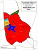
First map 1887 - red marker top right is where Holly Bank appears - I tried to include Haunch Farm to help.
 Second map 1905 with n outline in red which bears a close resemblance to the land in your map identified to Catharine Wheeler. I wonder if the wheeler was a coincidence?

First map 1887 - red marker top right is where Holly Bank appears - I tried to include Haunch Farm to help.
Attachments
Radiorails
master brummie
That had also crossed my mind Lyn. That's three of us who think that!probably of no interest but i did wonder if wheelers lane was named after someone who had lived there for many years and was by trade a wheeler...just a thought

pjmburns
master brummie
Just been re-reading Bill Dargue's comment about the turnpike road and realise it could be interpreted in two ways. The earlier route followed Valentine Road ...... Wheeler's Lane meaning they were already named or followed the route that we now know by those names. If the latter then it might have been named after the Wheelers family but it had been named by 1831. So we need to know when they started farming the land.
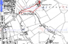
Have just found Catherine Wheeler on the tithe map dated 1840. she occupied two areas of land numbered 3124 and 3125, marked in red on the map, which seem to be on Wheelers Lane, though it is not named as such . Also entry regarding her. One plot is a house and garden, the other looks like "Pleck"


Phil
Gone, but not forgotten.
Have just found Catherine Wheeler on the tithe map dated 1840. she occupied two areas of land numbered 3124 and 3125, marked in red on the map, which seem to be on Wheelers Lane, though it is not named as such . Also entry regarding her. One plot is a house and garden, the other looks like "Pleck"
Mike I attach the definition of "Pleck" as Janice has stated it means "small plot of land" I would doubt it anywhere big enough to be described as a farm or even smallholding.
PLECK
Late Middle English (in an earlier sense). Immediate origin uncertain. Perhaps the reflex of an unattested Old English *plecce, and hence cognate with Middle Dutch plecke, plec place, plot, spot, stain, blemish (Dutch plek), Middle Low German plecke, plechke piece of ground, place (German regional (Low German) Plek, Pleck place, spot, also stain), apparently from a variant (with i-mutation) of the same base as Middle Dutch placke, plac stain, spot (Dutch plak patch, rag, stain, spot, also place), Middle Low German placke, plak stain, small piece, rag, plot, village (German regional (Low German) Plak, Plakke, Placke, Placken; perhaps goes to Middle High German placke patch; German regional (chiefly northern) Placken); further etymology uncertain and disputed: perhaps related to Middle Dutch plagghe rag (Dutch plag), Middle Low German plagge turf, rag (German regional (Low German) Plagge), Old Icelandic plagg luggage, Old Swedish plag piece of clothing (Swedish plagg).
pjmburns
master brummie
At the moment I am trying to trace back the only farm I can find on Wheeler's Lane - Holly Bank Farm. I found it on 1891 census with a Thomas Hadley and his wife Myra. He is listed there as a farmer in 1901 and in 1911. Thomas was still there when he died in 1925 as I found the probate. Thomas wasn't there on 1881 census as he is listed at Woodbridge Road(I assume in Moseley) as a farmer and grocer. So my next task is to see if I can find it on the 1881 census and then go back to see if I can work out when the Wheeler's left.
I agree with Phil that the land from 1840 on its own was probably not large enough to be called a "farm" so assume it merged with other land to form Holly Bank ... but when?
I agree with Phil that the land from 1840 on its own was probably not large enough to be called a "farm" so assume it merged with other land to form Holly Bank ... but when?
Attachments
Thanks for all your help with this; you're great!
I found the marriage cert for Thomas and Catherine nee Holland, at St Philips, 5 Sep 1802. Thomas and Catherine are recorded as parents of the three children, the two oldest of whom were baptised at St Marys in Moseley.
Despite being mentioned on youngest son Joseph's marriage cert I can find nothing more about Thomas..?
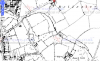
on the 41 census the wheeler family are at alcester lanes end the next address after that is haunch lane...map below..sorry if ive gone over old ground but i cant see where wheelers lane come into this because if you look at the overlay map alcester lanes end is near taylor road and alcester road south unless i have missed something which is quite poss knowing me but in post 1 it was suggested that the wheelers lived near the junction of wheelers lane and haunch lane but there is quite a distance between that location and alcester lanes end as shows on the map
https://maps.nls.uk/geo/explore/#zoom=16&lat=52.4219&lon=-1.8898&layers=6&b=3
https://maps.nls.uk/geo/explore/#zoom=16&lat=52.4219&lon=-1.8898&layers=6&b=3
Last edited:
pjmburns
master brummie
The problem is we know from the 1838 tithe map #32 that the land was in Wheelers Lane. I am not sure how far the area known as Alcester Lanes End actually extends. but it is only around half a mile by road from Taylor Road (Alcester Lanes End) to the junction of Wheeler's Lane and Haunch Lane. I think we are agreed that the "farm" from #1 is not where Wheeler's Lane meets Haunch Lane but further along and that the land became part of Holly Bank Farm at some point.
pjmburns
master brummie
I don't think we can see their building. Holly Bank Farm is on later maps. I posted a 1905 map in #33 and marked what I think is the land which belonged to Catharine (very similar shape), Also indicated possible site on 1887 map but nothing earlier yet to show her building. Mike's tithe map also showed the site but no building.
devonjim
master brummie
James Taylor owned Haunch Farm. Quite wealthy, lord of the manor etc. a banker, made buttons & snuff boxes, I think had a connection with Lloyds bank but this needs to be confirmed.right im with you now janice...also noticed on the map post 32 james taylor had land next to catherine no doubt that is where taylor road got its name from
https://www.lloydsbankinggroup.com/...fe-at-lloyds-bank/the-taylors-of-lloyds-bank/