This London Gazette extract quotes the existence of a "Vine Inn, Park Street, St Nicholls, near Aston park-wall" back in 1839. Of course, not necessarily the current building, but presumably a building on the site of the present Vine. Viv.

-
Welcome to this forum . We are a worldwide group with a common interest in Birmingham and its history. While here, please follow a few simple rules. We ask that you respect other members, thank those who have helped you and please keep your contributions on-topic with the thread.
We do hope you enjoy your visit. BHF Admin Team
You are using an out of date browser. It may not display this or other websites correctly.
You should upgrade or use an alternative browser.
You should upgrade or use an alternative browser.
Vine Inn Lichfield Road Aston
- Thread starter ellbrown
- Start date
Good point Mike. I also wondered where St Nicholls was. Then I considered whether it was likely there were two Vine Inns in close proximity near Park Wall. But couldn't come to any conclusion. Viv.
Radiorails
master brummie
Mike, I am a little puzzled by our map (post 39). It shows the canal to the west whereas, as far as I know, the canal is to the east of the Vine. However, in Aston it seems that there are/were three pubs named with vine in their name: (according to the Aston Brook web site)
The Vine - 17, Bracebridge Street
Vine - 157, Lichfield Road - the one under discussion I believe
Vine Inn - 160, Newtown Row.
I mention this to save us getting into a state of confusion - quite an easy achievement I guess for some of us.
Just a reminder of my post 40.
But is either the Vine on Bracebridge Street or the Vine on Newtown Row near Park-Wall ? Park Wall is labelled on the post-1758 conjectural map in post #33. The nearest one to Park Wall seems to be the Vine on Lichfield Road.Viv.
But is either the Vine on Bracebridge Street or the Vine on Newtown Row near Park-Wall ? Park Wall is labelled on the post-1758 conjectural map in post #33. The nearest one to Park Wall seems to be the Vine on Lichfield Road.Viv.
hi viv i always find maps like the one on post 33 very deceiving with distances but i notice that park wall runs off lozells lane which became lozells road so to me the vine at newtown row looks to be closer to park wall...this is just through my eyes so i am most likely way off lol
lyn
So was there ever a Saint Nicholls church near Lozells Road (Park Wall) ?
ahh hang on viv...i could be throwing this way off beam but somewhere in the back of my mind i think years ago i was either told or read that near to where the royal oak pub now stands at the end of lozells road there was an old burial ground and that bodies are still there...if i am correct with that i wonder if it could have been this st nicholl church..actually its an unusual name for a church..not one i have come accross..there was a st nicholas church in lower tower st but thats nothing to do with this..what map is st nicholl marked on viv..i cant seem to find it
It's in the Gazette extract Lyn, post #61. The address given is "near the Vine Inn, Park Street, St Nicholls, near park-wall".
Viv.
Viv.
just read it viv..must have missed it....yes reading that it says the vine inn park st then it must be referring to if not the one thats there now but certainly a vine inn that was there....the saint nicholls bit is baffling me a bit....more research i think
lyn
lyn
Frothblower
Lubrication In Moderation


Radiorails
master brummie
There seems to be a multitude of places called Vine:
https://birminghamhistory.co.uk/forum/index.php?threads/2-to-identify-please.15436/
See a list by Phil in this thread -post 15, pictures can be seen of some pubs in post 59 by Mike Gee and more of the Bracebridge Street place in posts 82 and 83.
The Vine threads seem to be troublesome - lets hope the places were less so.
Do any of the other "Vines" have a Park Street address as in post #61 ? Is it just coincidental that the Vine Inn on Lichfield Road is at the junction with Park Street ? Viv.
Radiorails
master brummie
Post 72 shows the place, which is the subject of the thread as being at the junction with Sandy Lane. In post 61 I am of the opinion that the St Nicholls really is a mistranslation of Nechells.
Radiorails
master brummie
Yes, I see now. Park Street is where the cars are parked in post 61. ")
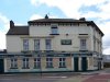
I've been looking at the changes to the building over time using the various maps posted. (Hopefully I've got the correct dates for each - let me know if any are wrongly labelled please). Comparisons show
1. A smaller footprint of the Vine in c.1845
2. and 3. The rear of the Vine becoming enclosed near the Park Street side as houses have been built on the former pleasure garden area.
4. Extension of the Vine on the Sandy Lane side, along Sandy Lane. Was this to provide function room facilities ? Access to the rear of the building was still possible.

And the current Google satellite view.

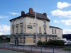
I find the Sandy Lane side of the building very confusing. The architecture is odd. It's obviously been altered/added to, but these three windows are confusing in the context of the whole. Any ideas ? Viv.

1. A smaller footprint of the Vine in c.1845
2. and 3. The rear of the Vine becoming enclosed near the Park Street side as houses have been built on the former pleasure garden area.
4. Extension of the Vine on the Sandy Lane side, along Sandy Lane. Was this to provide function room facilities ? Access to the rear of the building was still possible.
And the current Google satellite view.
I find the Sandy Lane side of the building very confusing. The architecture is odd. It's obviously been altered/added to, but these three windows are confusing in the context of the whole. Any ideas ? Viv.
Last edited:

Pedrocut
Master Barmmie
nice snippet pedro but i think it was 152 years ago not 100....no doubt a typo error
lyn
Yes my typo! Have amended to the year we won the World Cup.
Lady Penelope
master brummie
Viv, your post #80 mentions the windows. I was also looking at the windows but from the point of view of Window Tax. I was hoping that this might help but not so far I'm afraid. The tax was introduced in 1747 and began with 10 windows and over. Various amounts for various numbers of windows. The number was reduced to 6 in 1808 and in 1825 raised to 8. So actually this tax doesn't help us at all. Except for the one thing that puzzles me which is if you were building after 1747 why would you include too many windows? Or did they extend the building and 'lose' some of the original ones? So many questions!
Lady Penelope
master brummie
I did wonder about that but I'm not convinced either way. Be interesting to see how the layout inside was originally wouldn't it?
One thing we know from the maps is that the Sandy Lane side of the building was extended after 1904. Viv.
Been studying the features. Don't have any answers as such, but a few observations:
The red dot in the first image shows a staircase leading nowhere ! The back of that building must once have provided an exit at that point. I notice there's now a fire exit nearer the Sandy Lane side.
The second image red dot is the point where the molding starts along the eaves of the back building - this is different. I also think the molding above the window, although the same as the three in that line, seems to probably have a join. This still doesn't make sense in terms of the overall window arrangement on this side, but suggests some alteration. The extent of alteration is the difficult bit. Viv.

The moldings:

The red dot in the first image shows a staircase leading nowhere ! The back of that building must once have provided an exit at that point. I notice there's now a fire exit nearer the Sandy Lane side.
The second image red dot is the point where the molding starts along the eaves of the back building - this is different. I also think the molding above the window, although the same as the three in that line, seems to probably have a join. This still doesn't make sense in terms of the overall window arrangement on this side, but suggests some alteration. The extent of alteration is the difficult bit. Viv.
The moldings:
Last edited:
So to summarise, I think this section is probably where the post-1904 alterations/extension took place. Viv.
