-
Welcome to this forum . We are a worldwide group with a common interest in Birmingham and its history. While here, please follow a few simple rules. We ask that you respect other members, thank those who have helped you and please keep your contributions on-topic with the thread.
We do hope you enjoy your visit. BHF Admin Team
You are using an out of date browser. It may not display this or other websites correctly.
You should upgrade or use an alternative browser.
You should upgrade or use an alternative browser.
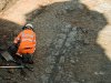
Victoria Square - uncovering an old road
- Thread starter horsencart
- Start date
horsencart
master brummie
The other thing I feel that I should mention is that the road way? appears to go under one corner of the old Post Office 1890? in Victoria Square this would mean that the road way was there before the Post office was build,
Heartland
master brummie
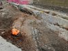
I notice the excavations for the Midlands Metro at the top of Pinfold Street in New Street near the former site of the Iron Man has uncovered what appears to be a narrow cobbled street. This length has a pronounced camber and stone lined drainage channels on either side. It is about 2ft below normal road level. It is quite narrow but would have been suitable no double for the medieval traffic of narrow carts and pack horses.
Such a structure should deserve investigation.
This forum has no assigned sub group for roads and bridges and perhaps it should if only to record turnpikes, pack horse ways, roads and motorways.
Such a structure should deserve investigation.
This forum has no assigned sub group for roads and bridges and perhaps it should if only to record turnpikes, pack horse ways, roads and motorways.
Radiorails
master brummie
Have a look at this thread there are already many posts about this road.
https://birminghamhistory.co.uk/for...d-in-victoria-square.48891/page-2#post-619542
https://birminghamhistory.co.uk/for...d-in-victoria-square.48891/page-2#post-619542
horsencart
master brummie
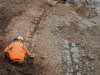
There has been what I would call as a development, more of the Roadway ? has been scraped to reveal at the end of the Roadway what to me looks like a base to a Roman Column ? the odd thing is that it is at the end and not to the right or left was a sign saying
Welcome to Birmingham please mind the natives as they bite,
was it a Mile Sign,
was a sign for religious reasons,
was it a sign celebrating a long lost roman soldier,
was it a sign that said you have reached the end of your journey
was it just a section from the 1960,s ,
the thought that did strike was that if the was some sort of column or small tower ? it would have been seen from a distance as there would have been no buildings near it? and it would have at the top of the hill?
there are the two photos there will be more as soon as I edited them https://www.flickr.com/photos/dofartshavelumps/42233302524/in/dateposted/
Four more here two relate to the Iron Man two relate too the Roman Column (alleged) https://www.flickr.com/photos/dofartshavelumps/29079857668/in/dateposted/
Last edited:

Heartland
master brummie
The length of road looks earlier than Victorian and the depth in the ground again would suggest it was from an earlier time. Joseph Makenna in his book Birmingham Street names states Pinfold Street was named after the pound where stray animals were kept until redeemed by their owner upon a payment of a fine, The street was established by 1731 and was probably 17th century in origin. New Street is one of the oldest in Birmingham and is mentioned in a deed 1397. In the 18th Century the Swine Market was held in Lower New Street and the upper part of New Street was known as Swinford Street
keny r
knowlegable brummie

Heartland
master brummie
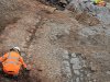
Thank you for that link, there is a wider discussion regarding what this road was. What has been uncovered is at the top of Pinfold Street and at the junction with New Street (old Swinford Street). There was a church opposite this road junction, Christchurch, if I recall. The road is a narrow with a camber with stone lining the drainage channels. Was this local stone?
Pinfold Street, itself, was once a long road that met up with Dudley Street, but was cut through when New Street Station was first constructed for the London & North Western Railway.
It appears that what has been uncovered may have been the width of this long road with footpaths and buildings lining the route.
Attached is a section of the 1785 map of Birmingham that shows Pinfold Street and Swinford Street. The Church is shown on this map and there are no buildings otherwise at this junction. Where the "Pinfold" was is another issue to be determined, but may have been nearer the Digbeth end of the street- in fact the map shows a pound at the junction with Peck Lane
Heartland
master brummie
Normally yes, but the original thread was posted in the General section. There are clear aspects of Birmingham History involved here as well as the wider study of how Birmingham developed. Before making my original post I searched the site, but could find no proper links- I did not think it would appear in General, and may be this is a problem for those such as myself keen on what has been mentioned in the forum.
Another point is that whilst Digbeth was a key part of Birmingham, it is best to look at other Birmingham areas. Pinfold Street was a link up the hill to what became an important and central part of Birmingham. It was here that the Town Hall was constructed. It was near here that St Phillips was constructed and New Street was an important throughfare. There were manufacturing premises and road waggon warehouses there once.
Another point is that whilst Digbeth was a key part of Birmingham, it is best to look at other Birmingham areas. Pinfold Street was a link up the hill to what became an important and central part of Birmingham. It was here that the Town Hall was constructed. It was near here that St Phillips was constructed and New Street was an important throughfare. There were manufacturing premises and road waggon warehouses there once.
horsencart
master brummie
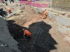
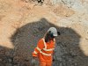
And that is where the problem is, they (the builders ) need to go deeper for the tram works if the roadway? is said to be Victorian it will possibly be broken up so that the work can continue if the roadway is said to be a lot older this may cause problems with the build, we will have to see what happens, I did have quick chat with one the workers yesterday, sadly I cannot repeat it
Radiorails
master brummie
Picture No. 8, in Ken's post 37, is interesting. The shade gives a much clearer picture of the road. It may be the angle of the photo I don't think so however - but the road does seem to curve to the right as it progresses away from the camera.
Are the channels running between the large stones for drainage ? Viv.
horsencart
master brummie
I would say yes to that
Are the channels running between the large stones for drainage ? Viv.
Eric Gibson
master brummie
Maybe one of those old Dickensian streets where they chucked the contents of the guzunder out of the upstairs window into the street. 
Some interesting road surfaces on this 1887 photo which has been on the Forum on several occasions. Can this throw any light on the surface ? Viv.

This 1751 map shows a broken dotted line coming along Bewdley Street (Ann Street/Colmore Row) veering off towards Pinfold Street (note Swinford Street later became the top end of New Street). What does the dotted line represent ? Has it any connection with the cobbled surface ? Viv.
Just discovered there are two threads on this subject so I am merging them together. The thread now comes within the History section.
Heartland - I have posted the same map. Didn't see your new thread (which I have now merged with the earlier thread). The map I posted claims to be 1751 - from the Eighteenth Century Birmingham site ( https://mappingbirmingham.blogspot.com/2012/06/blank-canvas-bennetts-hill-waterloo.html)
Can someone confirm which is the correct date please ?
Viv.
just catching up with this thread as i have been away....absolutely fascinating and proves once again that there is still plenty of history beneath our feet...it could be any of the suggested things but i am sure that the experts will soon find out for us.. i may find time to get up and take a look myself before it disappears forever
lyn
lyn
Last edited:
keny r
knowlegable brummie
Has this is in the general discussion would like to mention there's work going on the shops on the far left of vivienne pic and the roller shutter has been exposed after been hidden for a long time .it's the last shop on the row and you can see some writing but can't make it out. Just thought I would say if your going to have a look at the road . I have some photos if your interested only pics I have in my collection are of canopies.
Heartland
master brummie
Vivienne, I used Mr McKenna's map copy, but will check for date. There are all sorts of maps that can be used, when I get time to look.
The road to Stourbridge, later Paradise Street, formed the turnpike road
Regarding the old road, it would be interesting to see if digging further down finds anything, or was the original road surface at a lesser depth there. The part through New Street Station, or Grand Central, would require fresh air archeology.
For those interested in Kenny r's post #54 about the old shutter uncovered at the junction of New Street/Pinfold Street, a link to the thread discussing the shutter is given below. Another Metro 'find'.
Metro has, it seems. agreed (in theory) to preserve the shutters and the recently uncovered road/track. But it remains to be seen of course. Viv.
https://birminghamhistory.co.uk/for...eet-shutter-bunnett-and-co.48583/#post-619650
Metro has, it seems. agreed (in theory) to preserve the shutters and the recently uncovered road/track. But it remains to be seen of course. Viv.
https://birminghamhistory.co.uk/for...eet-shutter-bunnett-and-co.48583/#post-619650

Though am not sure about that. Looking at the rest of the map, taking this feature from where it leaves Pinfold stseems to start on the edge of the map (though may merely go further off the map), up the present Colmore Row, then turns down Stafford St, turns off Stafford st to the east and runs behind the houses in Stafford St to Coleshill St, down Coleshill St for a short way, then off Southeast to cut across Masshouse Lane, then down moor st, turning off half way down.It then seems to change colour to red dots, going south taking a not well determined path through the houses between Moor st and High St, crossing High St south and close to the junction with New St, going behind the southern buildings in New St to Peck Lane to Pinfold st, and then behind the buildings of Pinfold st to where we started. The colour of the dots changes back to black at the bottom of Pack Lane.
So it looks a bit like some sort of boundary.
So it looks a bit like some sort of boundary.
Thanks Mike. That's helpful. Wonder if it was a track specifically for cattle/livestock which were driven to the 'pinfold'. The channels in the track might have been to drain away droppings etc !! Viv.
Was writing at the same time Mike. Even if it was a boundary line, it's interesting that the uncovered track could be situated on that boundary. Viv.