-
Welcome to this forum . We are a worldwide group with a common interest in Birmingham and its history. While here, please follow a few simple rules. We ask that you respect other members, thank those who have helped you and please keep your contributions on-topic with the thread.
We do hope you enjoy your visit. BHF Admin Team
You are using an out of date browser. It may not display this or other websites correctly.
You should upgrade or use an alternative browser.
You should upgrade or use an alternative browser.
Tamworth Road Kingsbury Road
- Thread starter oldMohawk
- Start date
Frothblower
Lubrication In Moderation
This is an interesting thread.
I also remember Glenthorne house, used to to go scrumping there when it was an asylum. Have been chased off by staff and patients a few times
I also remember Glenthorne house, used to to go scrumping there when it was an asylum. Have been chased off by staff and patients a few times
Frothblower
Lubrication In Moderation
Well looks like my post 592 was wrong. The carriage may have been coming the other way down Kingsbury road (Tamworth Road) and turning right into Glenthorne Estate ?
It was certainly the route we took to travel to Tamworth.Must just be a local name for Kingsbury road
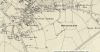
I suppose it depends on whether the Glenthorne estate was just the immediate area around the house or larger. To me "estate" might indicate that it comprised a larger area, in which case. looking at the c1890 map, as far as I can see the cart could have been in 4 positions, marked by different coloured arrows on the map. Possibly some local members might know if my assumption is incorrect.

Frothblower
Lubrication In Moderation
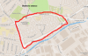
froth i will have a look at that in a min...i was just going to say that the cart passed a large building on his left before turning right would need to see if we can find a building on the map that fits..dont know if that may help..also can someone pinpoint on the map where the entrance is to glenthorne estate
Last edited:
Frothblower
Lubrication In Moderation
They look like farm buildings to me Lyn. If I'm correct Rookery house estate ( Rookery park) is on the other side of the road
ok thanks froth..must say i am finding this very interesting...although not my neck of the woods i learn all the time...such a lot of lovely buildings gone..just to the left of glenthorne was pype hall and a MOAT.. on the ground now is the kingsbury leisure centre..must say i wouldnt be without this great map site now as you can move the blue dot to see what is there now..
https://maps.nls.uk/geo/explore/#zoom=17&lat=52.5156&lon=-1.8388&layers=6&b=1
https://maps.nls.uk/geo/explore/#zoom=17&lat=52.5156&lon=-1.8388&layers=6&b=1
Frothblower
Lubrication In Moderation
Yes Lyn must have been a really posh area. 3 big houses within touching distance... Rookery house, Birches Green house and Glenthorne house.
i agree froth...as with my house your house is on what used to be open fields...as you say we may never know for certain where the cart was turning but it must have been very close to glenthorne estate because of where the proposed sign is pitched up and we now know that there was indeed a tamworth road...worth all the effort just to find that out..")
Last edited:
oldMohawk
gone but not forgotten
I suppose any junction on the old Kingsbury Rd could be the site. A possiblility is the one below. A nearby Nickel Works with maybe a demand for gas, and the nearby canal able to transport coal and coke. Maybe old newspapers 1901 onwards might have a report about the public enquiry or is there an archive of public enquiries which would possibly have a site map ?

Frothblower
Lubrication In Moderation

Frothblower
Lubrication In Moderation
This strengthens my argument
Frothblower
Lubrication In Moderation


Frothblower
Lubrication In Moderation
Birches Green House now and then

thanks for that snippet pedro..very interesting read..froth i know what i would rather be looking at..considering the area and the house have the same name it really is a shame it was demolished they could at least preserved some of its history ..
lyn
lyn
zzf00l
master brummie
This photo is dated 1904 with a location given as Tamworth Road Erdington. Wherever it was I would think the local residents would not be too happy about the City of Birmingham proposing to build a gasworks there. I cannot find a 'Tamworth Road' in Erdington so not exactly sure where this is.
View attachment 113456
zzf00l
master brummie
I would like to add that the picture of the old Birches Green House (taken from my bedroom window) belonged to the Darlington family, they owned the large wood mill adjacent to it and you can still (amazingly) find the family burial vault in the graveyard at St Barnabas Church. The years between the two pictures posted by Frothblower we had the Mobil Petrol Station just down from Spring Lane effectively in front of the old house and of course on the corner of Spring Lane and Kingsbury Road and next to the Mobil Station was Copsons the plumbers merchants.