• Welcome to this forum . We are a worldwide group with a common interest in Birmingham and its history. While here, please follow a few simple rules. We ask that you respect other members, thank those who have helped you and please keep your contributions on-topic with the thread.

    We do hope you enjoy your visit. BHF Admin Team

Some more old slide photos

  • Thread starter Thread starter 500miles
  • Start date Start date
5

500miles

Guest
Here are some more old slide photos. I think these were probably taken from the roof of Ansells brewery as well in the early 70's (although I'm happy to be corrected).
 

Attachments

  • 1 Aston Aerial View from Aston Brewery  (4).JPG
    1 Aston Aerial View from Aston Brewery (4).JPG
    224.7 KB · Views: 13
  • 2 Aston Aerial View from Aston Brewery  (2).JPG
    2 Aston Aerial View from Aston Brewery (2).JPG
    255.7 KB · Views: 12
  • 3 Aston Aerial View from Aston Brewery  (3).JPG
    3 Aston Aerial View from Aston Brewery (3).JPG
    168.9 KB · Views: 12
Last edited by a moderator:
The first one is looking towards Nechells Power Station (now demolished )
The second one --not got me bearing yet
The third one looking towards the town centre
Dek
 
I think the second one is looking towards Manor Rd School with the railway in the background. Dek
 
Second pic seems to be overlooking Salford park as it looks like the expressway, spaghetti junction and the M6 can be seen. Just a thought.
 
On the first photo to the right, is it the back of Thompsons where they slaughtered the animals?. Jean.
 
Paul it does look like it but even Pete who has been on that roof many a night while working shifts can not make them out. Jean.
 
The second photo. On the right you can see 2 of the 3 flats that overlooked Salford reservoir. I think that is Icknield Street School just in front of the Aston Expressway running though in the distance. On the left out of shot is Victoria road/Albert road junction we've all been talking about the last few days.
 
the middle one shows victoria rd, vicarage rd,and sycamore rd, the block of flats on the far right was in aston hall rd, the nearer block,i think beale st.
 
the school shown in the middle one is manor park girls school, you can also see the top of aston church spire, top left.
 
the school shown in the middle one is manor park girls school, you can also see the top of aston church spire, top left.

Thats where i meant post # 4 not my side of town G G Jean should know i think she went there. Dek
 
picture one seems to show the view from the opposite side to picture two,
towards saltley, the white building shown between the chimney's and gas
holders could be the radiation/johnny wrights thimblemill lane.
 
Dek yes I did but I hate to look at that sight it looks like a bomb hit it. I thought that must be Aston Church Paulyx but Pete has asked if that is indeed Thompsons to the right of the first photo?. Jean.
 
picture one seems to show the view from the opposite side to picture two,
towards saltley, the white building shown between the chimney's and gas
holders could be the radiation/johnny wrights thimblemill lane.

Yes you,re right Paulyx and right in the background you can make out Castle Vale .Dek
 
the first picture one can see very clearly Johnny Wrights-Radiation Ltd, how it ever stayed that white l'll never know with all the smoke and pollution about....it really is a great picture , l had my first job there started Jan 1st 1951...l always thought it a really" posh", building, pity its all gone now..Brenda
 
Those smashing pictures are a fabulous record of the remains of the old with the start of the new. They are a great help to people like me who saw little of Birmingham between 1960 and 2000, and who find it hard to relate past with present. But it is still very fascinating.
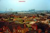
The first two pictures of the first set were taken from the same point as the view in the earlier posting on another thread, but at different angles, the first view looking east-north-east towards Bromford, before the bottom part of Victoria Road was redeveloped and before Waterlinks Boulevard and Park Circus were built. The old junction of Victoria Road with Lichfield Road was behind the chapel, and you can follow Lichfield Road on the right, coming from Aston Cross well off the picture, behind the camera. The school in the left foreground was in Vicarage road, The multi-storey factories are (or were) in Thimble Mill Lane, and the Nechells cooling towers and gasholder are easily recognisable.
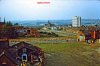
The second view is looking pretty well due north towards New Oscott. Victoria Road crosses from left to right – the cleared area was the old Police Station. Vicarage Road continues away to Sycamore Road, with its schools. The spire of the Parish Church is on the left; the railway viaduct between Aston and Gravelly Hill Stations is on the right, and a brand-new Spaghetti Junction is visible behind the Salford Park Flats.
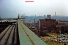
The third view is taken a few steps away, round the corner looking moreorless north towards the city centre. The rump of Park Road would immediate below the parapet wall, with Aston Cross just out of the picture. The HP Sauce factory is clearly visible, with Aston Road and the Aston Expressway
The picture posted later must have been taken at about the same time from a sports ground south of Brookvale Park, again looking north towards the city centre. The spur from the M6 from Bescot branching off to the A38(M) Aston Expressway and the A38 to wards Lichfield is in the right foreground, while the through lanes to and from Coventry are behind. The flyover connections to the Expressway and the electricity pylons obscure the view of the flats in Salford Park. The buildings in the foreground were in Hillside Road amd Kegworth Road.
Peter
 
Peter the spots ground would be The Magnet Center belonging to the G.E.C but if i remember correctly the railway passes just about there it may be on the embankment.Dek
 
Dek,
The railway runs south of Hillside Road, in other words behind (and below) the buildings in your last picture. It would curve under the first or second span of the M6 viaduct from the right, and continue behind the buildings and cross Slade Road to continue climbing to Gravelly Hill Station.
I believe the Sutton line wasn't electrified until the 1980s, so when your picture was taken, there would have been no overhead wires to distinguish it.
Peter
 
The back of the Magnet Club buildimg is at the bottom of the embankment in the fore ground...last picture.
Have lightened the shadows of these great shots a bit...hope it helps.
 
Thank you to everyone who has posted messages about the pictures. My Dad would have been thrilled to bits to know they were so appreciated and enjoyed.
 
Did your dad work at Ansells 500 Miles?. Jean.

Yes, he did. He was a delivery driver. He worked at Aston Cross from about 1960 (I think) until 1981. His name was Raymond Shelley. My Grandad also worked for them too - George Nelson Ellis. I used to love going to the children's Christmas parties.
 
500miles, Thanks for posting your Dad`s photos the colours are so brilliant & Rupert, yours a great, they have survived the long journey from Canada in great condition!!!. Len.
 
Len, non of them belong to me. I just manipulated the ones posted by 500 and Pedrocut using software, so that some detail could be exposed in the shadows of the originals. Thanks anyway.
 
500miles...what marvelous pics you have posted...thank you and please if you have any more we would love to see them...

many thanks

lyn
 
500miles. Thanks for those brilliant pictures. Great to see. If there are any more available, please feel free to post .
 
Back
Top