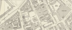
I'm a bit late replying to your enquiry. It seems that Sheep Street was in the Gosta Green area to the north east of Birmingham City Centre (or town centre then as Birmingham did not become a city until 1889). My map (attached) from the 1950s shows Sheep Street and landmarks at the time would have been the public baths in Woodcock Street (to the right) and the Central Fire Station, in the top left corner of the map. The whole of this area and many of the streets including Sheep Street have disappeared to become the campus for Aston University.
In the map you can see the two remaining courts in Sheep Street (in the 1950s) 11 & 12 to the to right side near to the top. Further down on the same side you can see the house numbers 37, 38 & 39. Next is an area with the word "Warehouse" and this may be where your ancestor's court (Court 6) would have been. Sylvia Sayers says that her relative John Raybould ran the Dog & Duck pub at number 40, so that would have been just there, next to number 39.
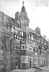
Taking a look at the map posted by MWS, which is very blurred, it seems that court 6 may have been on the opposite side of the road where Kyle Hall was built around 1893, this was a public hall and used as gymnasium.
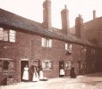
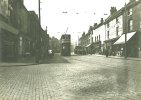
I've attached a photograph of Kyle Hall (which may have been built where court 6 was, maps of Sheep Street from c1893 and c1950, along with a photograph of Aston Road from the north end of Sheep Street and a photograph of some typical court houses from Birmingham in around 1910.
It's worth noting that the census shows the address as 6ct 16H. This means court 6, but the 16 refers to the house number in the court. They would not have been apartments, but back-to-back houses.
I hope this helps.
Kyle Hall - c1893
Sheep Street - map c1889
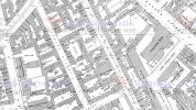
Sheep Street - map c1950
Aston Street - looking south from corner of Sheep Street - 1934
A typical Birmingham court - Court 10 Cheapside - c1910
