-
Welcome to this forum . We are a worldwide group with a common interest in Birmingham and its history. While here, please follow a few simple rules. We ask that you respect other members, thank those who have helped you and please keep your contributions on-topic with the thread.
We do hope you enjoy your visit. BHF Admin Team
You are using an out of date browser. It may not display this or other websites correctly.
You should upgrade or use an alternative browser.
You should upgrade or use an alternative browser.
See Birmingham by Post Card
- Thread starter motorman-mike
- Start date
paul stacey
master brummie
I do hope so Mike, it was my local for a while. Paul
Lady Penelope
master brummie
I has occasion to visit the church some years ago and it is now round the corner in Monument Road itself. It stands on the former site of a cinema (name escapes me) but is just on the bend of the road. I was researching a block of houses which once stood there called 'Monument Place'. Slightly clearer photo of this baptist church below. I expect they got a considerable sum for the prime site on Hagley Road and like a lot of other churches felt that with shrinking congregations the upkeep of such a large building was too much.

DavidGrain
master brummie
I knew the cinema as the Monument after the name of the road, then like a lot of others it was just called ABC. Only went there once. Learned a lot in the back rows, No further commentI has occasion to visit the church some years ago and it is now round the corner in Monument Road itself. It stands on the former site of a cinema (name escapes me) but is just on the bend of the road. I was researching a block of houses which once stood there called 'Monument Place'. Slightly clearer photo of this baptist church below. I expect they got a considerable sum for the prime site on Hagley Road and like a lot of other churches felt that with shrinking congregations the upkeep of such a large building was too much.
View attachment 153841
Jayell
master brummie
I always knew it as the Edgbaston cinema in Monument Road. I remember seeing Patrick Boone in Friendly Persuasion there in about 1957/1958I knew the cinema as the Monument after the name of the road, then like a lot of others it was just called ABC. Only went there once. Learned a lot in the back rows, No further comment
devonjim
master brummie
Phil, belated interest! I learnt today that one of my great grans was married from Clevedon Rd in 1886, no number given. Wedding at St Lukes Church. Groom from Bell Barn Road.An old post card showing Clevedon Road, Balsall Heath.
View attachment 137431
G G Jean
Brummy Wench.
You wouldn't need curtains up at that window!!!.That tree badly needs a heavy prune - it's not really a suitable tree for that position.
Maurice
Richard Dye
master brummie
This is how I remember the Bull Ring!
Albert Jordan
New Member
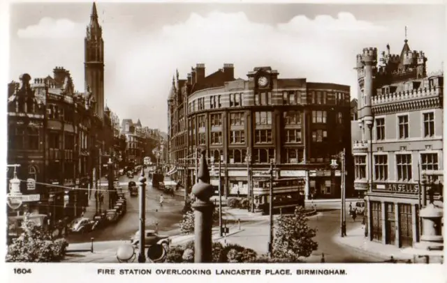
The photograph is probably being taken from the Fire Station itself. The white bar (of sunlight?) on Corporation Street would be coming from Ryder Street, where I lived till 1955, and the tower is the Central Methodist church whose ministrer in those days was the striking figure of the Reverend Maldwyn Edwards whose fiery sermons attracted a large congregation. I''m noticing for the first time, the crenellation and fairy castle towers atop the Ansells pub!The other end of Corporation Street c.1940s. Note the odd caption - the Fire Station is nowhere to be seen.
Lloyd
master brummie
Actually taken from the Halford's building, later totally destroyed by fire despite its proximity to the Central Fire Station off shot to the left.The photograph is probably being taken from the Fire Station itself. The white bar (of sunlight?) on Corporation Street would be coming from Ryder Street, where I lived till 1955, and the tower is the Central Methodist church whose ministrer in those days was the striking figure of the Reverend Maldwyn Edwards whose fiery sermons attracted a large congregation. I''m noticing for the first time, the crenellation and fairy castle towers atop the Ansells pub!
mizzyjo
master brummie
I thought the same RobTI thought it was health not feet - see the other h(ear) two lines above
Two
master brummie
Re Post 2079 - Fire Station overlooking Lancaster Place. (Re - Location of photographer).

The Postcard title should have been "View" from Fire Station perhaps.
The Picture has definitely been taken from Central Fire Station.
Look how close the Castle Public House opposite is on the right.
The height of the Tram Pole outside the window matches the height of a second Floor window on the Fire Station.
The photographer would have most likely been positioned in one the windows circled in Red.
DavidGrain
master brummie
I agree that the photo was taken from the Fire Station. A view from Halfords would have been towards the street to the left of Corporation Street whose name I have forgotten but which is now under the Queensway.
A WOODHALL
knowlegable brummie
HI David, according to the 1921 census FMP my grandmother Mabel Redgrave worked at Werff Bros in City ArcardeThis post card was sold on ebay two months ago for £4.99. It is an advertising postcard saying that they were at 336 Stratford Street in 1900. My mother used to shop at Werff's on the corner of Temple Row and Bull Street. View attachment 146556View attachment 146557
The post card that oldMohawk has posted of a shop on the Coventry Road is dated 1910.
Bob Davis
Bob Davis
The date of 1946 has to br wrong as there is a Nechells trolley bus in the picture and they ceased running at the start of WWII.Re Post 2079 - Fire Station overlooking Lancaster Place. (Re - Location of photographer).
View attachment 166979
The Postcard title should have been "View" from Fire Station perhaps.
The Picture has definitely been taken from Central Fire Station.
Look how close the Castle Public House opposite is on the right.
The height of the Tram Pole outside the window matches the height of a second Floor window on the Fire Station.
The photographer would have most likely been positioned in one the windows circled in Red.
View attachment 166980View attachment 166981
Bob
Fiona Gough
New Member
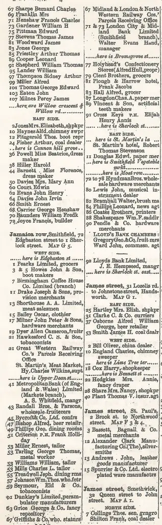
New member here. Regarding Hyndman Bros.
Hi there. Interesting post above. May I just note that the Birmingham Rate books for 1906 for Jamaica Row have William James Hyndman, Robert Hyndman and Hugh Morrison Hyndman (my relatives) renting offices and warehouses at 72 Jamaica Row. Owner listed as Atlas Insurance Company. The Hyndmans ran a hardware dealership.Richie
This picture has been on before on https://forum.birminghamhistory.co.uk/showthread.php?p=46699.It is a better scan there and it can be seen that the next building is the xxx Arms.
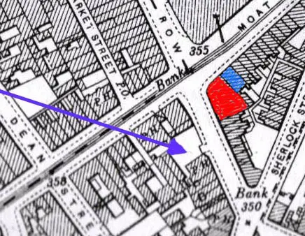
In the previous post it was said that the fire was at Hyndman Bros. Cromwell claimed that the map (1) he presented (blue arrow on map) showed the pub next door to the fire, but I think this must be incorrect, in that this pub (which is called the Plough & Harrow in Kellys 1876, 1896 and 1912) in addition to never having been called the xxxx Arms, was not next to the corner plot, with another plot between . On examining Kelly's , the 1896 edition does not mention Hyndman bros, but the 1912 ed.(presumably after rebuilding) puts them at 72-78 Jamaica st (see attached). The 1890 map attached shows a PH next to this in Moat Row. the 1876, 1896, 1912 1nd 1921 Kelly's all refer to it as a beer retailer, though by 1940 it has become Harveys Commercial hotel.
Therefore the building to the left of the photo is the unnamed pub at 23 Moat Row , and the buildings down to the right at nos 82-90 Jamaica Row.
The end of the buildings on the right is the junction with Sherlock St, which on the map is shown to be a wideish junction, as appears in the photo.
Mike
A WOODHALL
knowlegable brummie
Hi Bob. I would love to have the postcards, it would be very kind of you. I miss Birmingham so much and take an avid interest. If you could send to Andrew Woodhall, 20 Maryport Court, Carlisle, CA2 5LY. Let me know of any costs. RegardsI have 19 old postcards, 14 pre 1960 and mainly pre 1940s and 5 modern coloured, all city centre, town hall, art gallery etc. If anyone would like them, please let me know with your address and they will be sent to you. Nothing exciting or dramatic.
Bob
Bob Davis
Bob Davis
Be posted tomorrowHi Bob. I would love to have the postcards, it would be very kind of you. I miss Birmingham so much and take an avid interest. If you could send to Andrew Woodhall, 20 Maryport Court, Carlisle, CA2 5LY. Let me know of any costs. Regards
Bob
I'm sure I posted this here before but I can't find it in this thread. Maybe it's in another thread or maybe it was lost in the 'hack':

'Darlingtons' puts it at the junction of Witton Road with Bevington Road, the date is the coronation of George V and Mary, which may explain the military and police uniforms.
Looking at the road surface and the overhead insulators, it looks like the tram line branched into Bevington Road, which may settle a discussion from a few years back in the Bevington Road thread.
paul stacey
master brummie
looks like TA parade?
Mark Tooze
master brummie
What a great photo - so much going on in it; from the parade to the shop windows, the signs and flags on the walls to the little girl in her shawl standing alone on the corner of the road. Whoever said "a picture paints a thousand words" was correct!!I'm sure I posted this here before but I can't find it in this thread. Maybe it's in another thread or maybe it was lost in the 'hack':
View attachment 217681
'Darlingtons' puts it at the junction of Witton Road with Bevington Road, the date is the coronation of George V and Mary, which may explain the military and police uniforms.
Looking at the road surface and the overhead insulators, it looks like the tram line branched into Bevington Road, which may settle a discussion from a few years back in the Bevington Road thread.
i think this is the corner...looks a lot different now though..bevington road to the right and the broadway to the left darlingtons also took in no 1 bevington roadI'm sure I posted this here before but I can't find it in this thread. Maybe it's in another thread or maybe it was lost in the 'hack':
View attachment 217681
'Darlingtons' puts it at the junction of Witton Road with Bevington Road, the date is the coronation of George V and Mary, which may explain the military and police uniforms.
Looking at the road surface and the overhead insulators, it looks like the tram line branched into Bevington Road, which may settle a discussion from a few years back in the Bevington Road thread.
lyn
The postcard is unusual in that it appears to be a bromide rather than a litho or gravure print, so more detail is visible. Further down the street is somebody's 'Celebrated Ices', advertised on a side blind 'though sadly the name is obscured by a hanging sign. There are a few words on the back of the postcard that read like a 115 year old Whatsapp message:What a great photo - so much going on in it; from the parade to the shop windows, the signs and flags on the walls to the little girl in her shawl standing alone on the corner of the road. Whoever said "a picture paints a thousand words" was correct!!

Kate was Kate Newbold nee Westwood who lived at 344 Witton Road, Mother was Amelia Sarah Westwood nee Seal who lived at 271 Park Road. But who was Sacko? Family lore has it that one of Kate's children was nicknamed Sacko. John Thomas Newbold would have been 7 years old at the time of this photograph so maybe he is one of the children just to the right of the little girl in the shawl. I guess we will never know. As for the Jeffcotts ...