-
Welcome to this forum . We are a worldwide group with a common interest in Birmingham and its history. While here, please follow a few simple rules. We ask that you respect other members, thank those who have helped you and please keep your contributions on-topic with the thread.
We do hope you enjoy your visit. BHF Admin Team
You are using an out of date browser. It may not display this or other websites correctly.
You should upgrade or use an alternative browser.
You should upgrade or use an alternative browser.
See Birmingham by Post Card
- Thread starter motorman-mike
- Start date
S
Stitcher
Guest
Thanks for correcting me there Rupert. As usual I am doing several things at once. I have edited it now. Thanks again.
S
Stitcher
Guest
I checked the picture and the writing Rupert you were right.
S
Stitcher
Guest

S
Stitcher
Guest
I wouldnt know Rupert, I found a load of old photos in a brief case that I used when I was a guide with my Taxi.
S
Stitcher
Guest
Can someone help with a small problem please. I can have a good clear picture. It will not upload and I was told to downsize it in pixel form and or inches. Sometimes downsizing in inches will not work until it is too small and downsizing the pixel count ruins the picture.
S
Stitcher
Guest
John, I had to cut quite a lot off the picture on all 4 sides to get it to upload. If I reduce the pixels it goes blotchy. What do I have to do?
S
Stitcher
Guest
I have an Epsom printer with photo scan. I can tell it how many pixels and what size I want. i/e A4 5x7 6x4 and upwards
S
Stitcher
Guest
I have MGI photosuit 8.06
gingerjon
GONE BUT NOT FORGOTTEN R.I.P.
this is what I do with paint shop pro
go to tool bar adjust click on adjust on drop down click on add remove noise
click on moire pattern removal adjust to 1 or 2 check which as the best result
then go to resize and resize by what ever percentage you need
go to tool bar adjust click on adjust on drop down click on add remove noise
click on moire pattern removal adjust to 1 or 2 check which as the best result
then go to resize and resize by what ever percentage you need
S
Stitcher
Guest
Thanks a million John. I will try that in the morning.
Merry Christmas to you and yours from me and mine.
Merry Christmas to you and yours from me and mine.
S
Stitcher
Guest

S
Stitcher
Guest
S
Stitcher
Guest
S
Stitcher
Guest
Unfortunately, I dont have the dates of these photos.
S
Stitcher
Guest
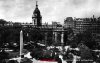
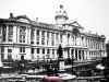
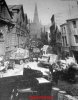
Sorry about that. I forgot the pictures. Unfortunately I do not have the date of these three. The first one is Paradise Street and Christchurch. Second is Moat Row, and the third New Street.
Attachments


Last edited by a moderator:
S
Stitcher
Guest
S
Stitcher
Guest

Sakura
master brummie
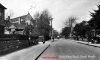
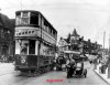
I posted this on Pubs but maybe it should be on here. It was a Chistmas card sent by a friend in Birmingham. I'm sure you all know the pub and the area, as it really hasn't changes a lot I don't think.
Love the pictures Stitcher.
Attachments
Last edited by a moderator:
Phil
Gone, but not forgotten.
Sakura
With my small knowledge of tram routes, I know the 70 route was a Navigation St to Rednal route along the Bristol Rd. I think the location of your card is the crossroads of Bristol Rd and Church Rd/ Bell Hill. Though I am not a 100% on this because Although having drank in the pub I do not remember the Bell public house having a clock. I'm sure that someone with a better knowledge of the area will put us on the right path.
Phil
S
Stitcher
Guest
Sakura, going by the road lay-out, if pmc is correct it could only be where he says, the lower end of Selly Oak or near the Horsefair looking away from city.
S
Stitcher
Guest
mikeejee, I knew if I wrote a load of rubbish someone would tell us where it was. I was looking at the turn in the road and never thought of the correct place.
Phil
Gone, but not forgotten.
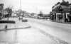
I had a quick look through my Northfield photo's. I think this is more or less the same view at a slightly later date. The Bell public house is actually behind the tram in the front on the Christmas card and is shown as the dark building on the left of the photo. I don't know what the building with the clock is, but I do seem to have a slight memory of it on the opposite corner of Bell Hill to the Bell Public House.
Phil
Phil
Attachments
Last edited: